Overview
Social Mix
Public Space
Amenities
Connections
Final Project
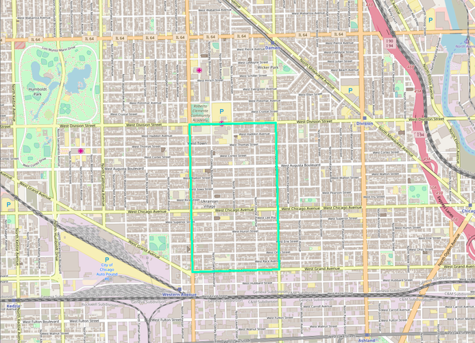
As seen in the aboveimage, Ukrainian Village is bounded by W. Division Street on the North, N. Damen Avenue on the East, W. Grand Avenue on the South, and W. Western Avenue on the West, with a total area of approximately 0.43 square miles according to Google Earth. Though the neighborhood's location in four different census tracts (2424, 2423, 2430, and 2429) made estimating population somewhat more difficult, it has about 10,000 denizens, according to Social Explorer. The neighborhood's rectangular shape and central commercial district on Chicago Avenue makes for an easy walk to most places one would need to go, but in both population and geographic size it is the size of 2-3 of Perry's neighborhoods.
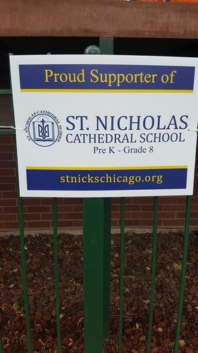
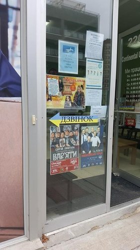
Ukrainian Village’s identity unsurprisingly reflects the area’s Ukrainian population, the neighborhood’s namesake. Along Chicago Ave., the neighborhood’s main commercial thoroughfare, a number of the storefronts have signage in both English and Ukrainian, as well as fliers advertising local events (such as the Ukrainian Fashion Festival and numerous events whose Ukrainian title I could not decipher) taped up in the windows (Figure 1). The Ukrainian influence is also evident in the frequent usage of blue and yellow, the colors of the Ukrainian flag, as well as the Ukrainian National State Emblem (Figure 2). Public signage further reinforce the identity of the neighborhood: banners on both sides of Chicago Avenue mark the street as Ukrainian Village, as do signs on Leavitt St.
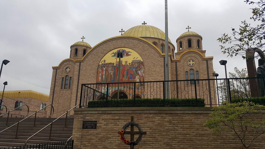
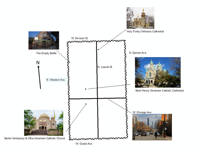
Beyond window dressing, a number of the shops cater to and reflect the neighborhood’s Ukrainian community. A number of Ukrainian restaurants can be found on Chicago Avenue, and scattered throughout the neighborhood are two Ukrainian Catholic churches (not including the Ukrainian Catholic Eparchy) and one Ukrainian Orthodox cathedral, as well as the Ukrainian National Museum, the Ukrainian Institute of Modern Art, and the Ukrainian Cultural Center. These churches’ architectural styling further reflects the Eastern European origin of their founders and congregations (Figure 3). All of these elements are centered on Chicago Avenue, but they extend both northwards and southwards, and it is for this reason that I chose to define Ukrainian Village as extending south to Grand Avenue; though about half of the online sources I found defined the neighborhood as terminating at Chicago Avenue, a number of Ukrainian signs and institutions are found between Chicago and Grand, as is Fiore’s Delicatessen, which proudly proclaims itself to be in Ukrainian Village.
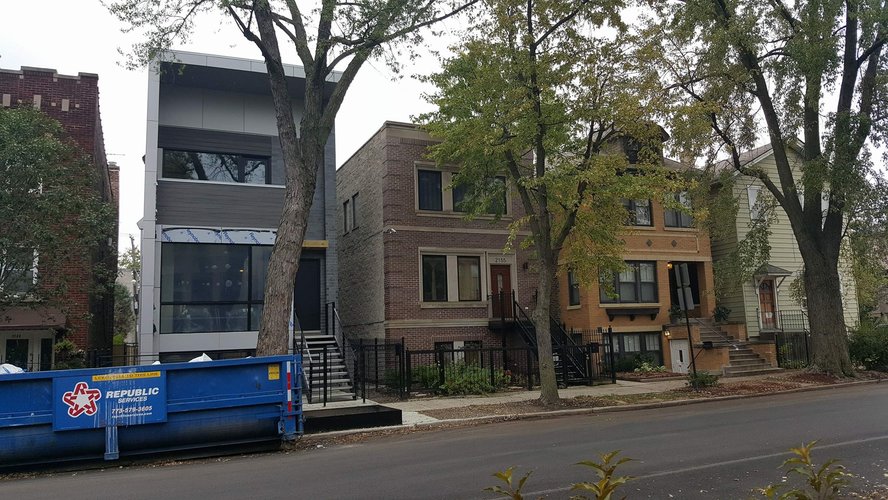
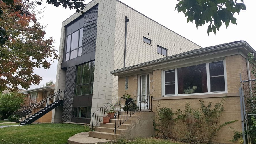
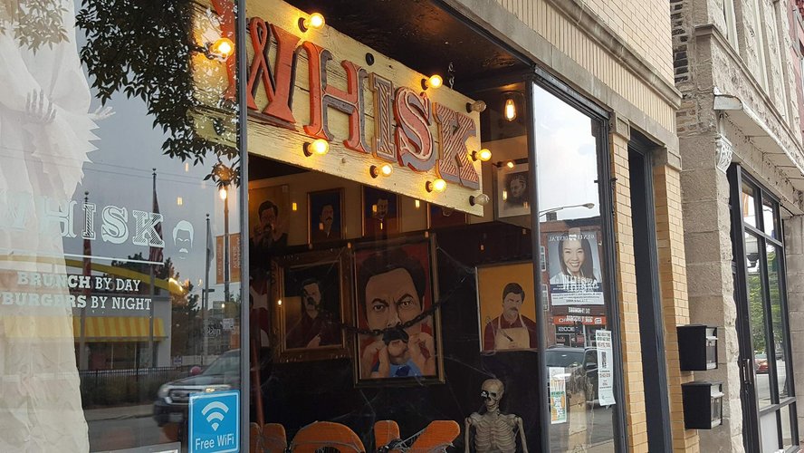
Even given the neighborhood’s relative boundedness as an area of Ukrainian residence and culture, there is evidence of influence from the neighborhoods to the North and East, namely Wicker Park and East Village, both of which are rapidly gentrifying. This comes primarily in the form of newer condominium buildings, which stand in stark contrast to the brownstones (both walk-up apartment buildings and free-standing homes or townhouses) and bungalows which are otherwise architecturally dominant in the neighborhood (Figures 4 and 5). Despite the new money creeping in from the edges, the neighborhood retains a feeling distinct from those of its neighbors, not only because of the Ukrainian accoutrements but also because of the distinctly middle-class shops and residences, which differ markedly from the newer, more bourgeois chain shops (such as Mariano’s and WHISK, a brunch restaurant [Figure 6]) found on Chicago Avenue towards the eastern edge of the neighborhood, as well as from the used car lots and warehouses to the south and west of the neighborhood core.
Though these newer condominiums may pose a danger to the social unity and identity, I actually found that the neighborhood remained architecturally coherent in spite of the intermingled new and old styles (if one can stomach the looks of some of the more tastelessly designed newer condominium buildings). In my opinion, the design of the neighborhood is far more threatened by the encroachment of single-story buildings set back behind empty and needlessly large parking lots, such as the Burger King on the west side of the district and its accompanying asphalt oasis, or Fatso’s Last Stand, which is more unfortunately placed in the heart of the neighborhood’s downtown but is at least locally owned. Thankfully, however, the new developer modernist condominium buildings and anti-urban drive-thru restaurants have not yet succeeded in making the neighborhood anything less than pleasant and easy to walk around.
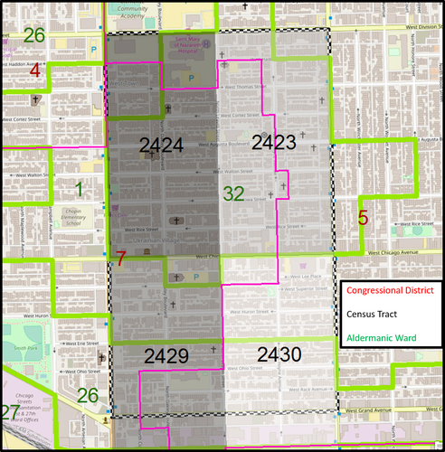
As seen in the above map, there are a number of overlapping delineations that include Ukrainian Village (enclosed by the black-and-white checkered line). The neighborhood is in: both the 7th and 5th Illinois Congressional Districts (labeled in red and shown by the pink line on the map); four different census tracts (2424, 2423, 2430, and 2429, shown in grayscale and labeled in black on the map); and three different aldermanic wards (the 1st, 32nd, and 26th, shown and labeled in green on the map). In addition, Ukrainian Village is wholly within the 13th Chicago Police District, the West Town community area, and the Vicariate III-B parish.
Ukrainian Village was initially settled by German immigrants in the years following the 1871 Chicago fire, but were quickly outnumbered by working-class Russian and Ukrainian immigrants who began settling in the area in the 1880s. Though the neighborhood had previously been farmland, it became more densely developed with the 1895 construction of the Paulina Connector, an elevated train line that ran along Paulina St. and linked the Blue and Pink lines until its decommissioning in 1964. At this same time around the turn of the century, many of the residents became employed building the large mansions in Wicker Park, the neighborhood’s wealthier neighborhood to the North. A second wave of immigration came in the 1910s as people fled political repression at home in Ukraine, and a third following World War II brought highly educated professionals (lawyers, doctors, writers, artists).
With this third period of immigration, a number of neighborhood institutions arose, allowing the Ukrainian community to become largely self-sufficient. These institutions included not only the neighborhood’s three Ukrainian churches, but the SelfReliance Ukrainian American Federal Credit Union and cultural centers such as the Ukrainian National Museum and the Ukrainian Institute of Modern Art. The growth of these and other neighborhood institutions helped Ukrainian Village become solidly middle-class despite its location adjacent to industrial areas and areas affected by poverty and crime; today, median household income is about $70,000. The fourth and most recent wave of Ukrainian immigration came in the 1990s following the dissolution of the Soviet Union. While it is unclear to what degree the layout of the neighborhood was planned by the city, it is evident that the strong neighborhood ties and sense of community had a significant impact on the development of the neighborhood as a place to work and live. That Ukrainian Village was the first to be formally designated as a neighborhood by the city when Jane Byrne did so in 1983 is perhaps a testament to its strong community ties and self-sufficiency with regards to cultural institutions and the other essentials of daily life, despite its relative lack of a neighborhood center or focal point as in areas like Lincoln Square. (This lack of focal point or central public space may indicate that the area was not highly planned by the city.)
In addition to helping the neighborhood remain middle-class during Chicago’s industrialization and subsequent socioeconomic changes, Ukrainian Village’s strong ethnic institutions may have also played a role – in conjunction with the neighborhood’s lack of direct rail transit – in slowing, though not entirely preventing, gentrification in the neighborhood. As mentioned in the “Identity” section, there is visible evidence of new money being poured into Ukrainian Village by developers, most notably in the boxy new condominium buildings on Chicago Avenue and throughout the rest of the neighborhood. A number of real estate companies and magazines have labeled Ukrainian Village one of the hottest neighborhoods in Chicago and the country. However, community advocacy (formalized in the Ukrainian Village Neighborhood Association, or UVNA) is working to stem the tide and influence of yuppies: the UVNA has succeeded in acquiring historical landmark designation for 75% of the neighborhood, preventing demolition of many of the neighborhood’s older buildings, and works to maintain the neighborhood’s identity by involving even non-Ukrainian immigrants in Ukrainian cultural activities. It remains to be seen whether the Ukrainian Village will retain its identity in the face of new arrivals or if its name will become the only vestige of its history as in many other Chicago neighborhoods.
“About Empty Bottle.” Empty Bottle (blog). Accessed October 17, 2017. http://emptybottle.com/about/.
“Chicago’s Holy Trinity Cathedral to Celebrate Feast of Saint John of Chicago.” Accessed October 17, 2017. http://domoca.org/news_121016_1.html.
Cook_County_GIS. “Congressional District.” Accessed October 16, 2017. Cook County Geographic Information Systems, 18 September 2017. Accessed through ArcGIS Online.
Massimo_slamwrote, 2013-04-22 13:13:00 Massimo_slam Massimo_slam 2013-04-22 13:13:00. “Ukrainian Village, Chicago.” Accessed October 17, 2017. https://massimo-slam.livejournal.com/12991.html.
Rcapacciodev. “Wards.” Accessed October 16, 2017. Published April 14, 2014. Accessed through ArcGIS Online.
“Ukrainian Village.” Accessed October 16, 2017. http://www.encyclopedia.chicagohistory.org/pages/2160.html.
“Ukrainian Village: St. Nicholas Ukrainian Greek Catholic Cathedral.” Accessed October 17, 2017. http://www.publicartinchicago.com/ukrainian-village-st-nicholas-ukrainian-greek-catholic-cathedral/.
“Ukrainian Village: Traditions Overcome ‘Hottest Neighborhood’ Label.” Chicagoly Magazine (blog). Accessed October 16, 2017. https://chicagolymag.com/web/2017/03/ukrainian-village-traditions-overcome-hottest-neighborhood-label/
https://chicagolymag.com/web/2017/03/ukrainian-village-traditions-overcome-hottest-neighborhood-label/
.
“US Demography 1790 to Present (HTML5).” Social Explorer. Accessed October 17, 2017. https://www.socialexplorer.com/a9676d974c/explore.
“Sts. Volodymyr & Olha Ukrainian Catholic Church.” Open House Chicago. Accessed October 17, 2017. https://openhousechicago.org/sites/site/sts-volodymyr-olha-ukrainian-catholic-church/.
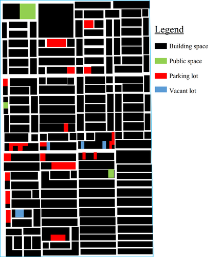
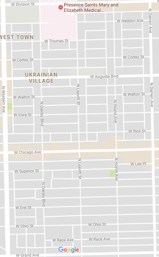
As seen in the above image, Ukrainian Village is a moderately well-defined neighborhood. There are few vacant lots in the neighborhood, and those that exist are rather small. The greatest detractor from the spatial definition of Ukrainian Village and its streets is the relatively high number of parking lots, especially unfortunate considering the fact that most of them front Chicago Avenue, the neighborhood's central street and main commercial strip. (The other parking lots to the north and south of the neighborhood, while taking away from the feeling of enclosure on the street, are somewhat more justified as they neighbor buildings that have a need for parking, such as churches, schools, and a hospital.) When walking throughout the neighborhood, however, the oases of parking are not as noticeable or disturbing as they are on the map.
In terms of public space, however, Ukrainian Village is lacking. While it has a decent number of civic buildings due to its many churches, there is little open space for residents to enjoy. Of the three public spaces in the neighborhood (marked in green on the above map), two are playgrounds and one is a square attached to a high school, and so none is particularly welcoming to adults. Furthermore, the spaces completely lack the sense of enclosure that the neighborhood's streets are fortunate enough to convey. Two are located on larger roads bordering the neighborhood, and the third is located on the end of a block such that street traffic moves past it on three sides. Perhaps due to these factors, the commercial strip of Chicago Avenue is the closest thing to a center the neighborhood possesses. Though no one corner is noticeably busier than the others, it is by far the most trafficked street and the neighborhood's most lively and populated location.
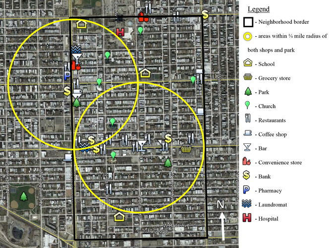
As evidenced by the above diagram, Ukrainian Village is home to a number of services that meet the daily needs of its residents. Chicago Avenue, around which the central yellow circle is placed, is where most shops and commercial services are located, including a laundromat, a number of restaurants, a couple of bars, and perhaps most importantly, a grocery store (which contains a pharmacy within it). Chicago Avenue is within a 5-minute walk of perhaps half of the neighborhood's residents.
Residents who live farther north and are thus more than a 5-minute walk away from Chicago Avenue can meet most daily needs in one of two secondary commercial strips, either on Western Avenue (around which the more northwestern of the yellow circles is centered) or on Division Street (the northern border of Ukrainian Village). While it is admittedly true that these commercial areas exist on the border of Ukrainian Village and not its core, and thus residents forced to walk to them are perhaps being less directly served by their neighborhood, both areas are home to a number of restaurants, a convenience store, a bank, and other shops. In order for residents of these areas to patronize a full-service grocery store, such as the Mariano's on Chicago Avenue (the shopping basket on the map), they will need to drive or walk up to 10 minutes.
In terms of non-commercial services, most everyone in the neighborhood is within walking distance of a school, whether they live north or south of Chicago Avenue. Churches are also well distributed throughout the neighborhood. Parks, on the other hand, are only within a 5-minute walk of people in the southern or northwestern part of the neighborhood; if you live in the northeast corner, it will probably take you about 10 minutes to walk to a park or playground. (It is perhaps worth repeating what is written in the Public Space section: namely, that the two parks located within Ukrainian Village are more accurately described as playgrounds; the nearest true park [where an unaccompanied adult would feel comfortable/be welcome] is located to the southwest of the neighborhood, which is more than a 5-minute walk for virtually everybody living in Ukrainian Village.) There is a hospital at the northern end of the neighborhood, but in most cases people do not walk themselves to the hospital.
Fortunately, there are a number of public transit stops located inside the neighborhood. Buses run along all of the streets bordering the neighborhood, as well as down Chicago Avenue; from these buses residents can get to an L stop and then to almost anywhere in Chicago. This is fortunate because there are a number of services not provided by Ukrainian Village, and for which residents will have to live the neighborhood. The most obviously missing services are a public library, a post office, and a movie theater, though I am sure that residents of the neighborhood could name many more.
Overall, I would say that the residents of Ukrainian Village are moderately able to meet their daily life needs with a 5-minute walk. Though the streets are pedestrian friendly (there are few parking and vacant lots, as mentioned in the Public Space section) and the neighborhood is safe and well-lit, about 20% of residents are not within walking distance of shops and open space (i.e., are located outside of the yellow circles). The percentage of residents who are not within a 5-minute walk of a full-service grocery store is even higher, approaching 45 percent. While more or less every resident is within a 5-minute walk of a school and a church, there is neither a public library nor a post office nor a movie theater within a quarter-mile radius of anyone in the neighborhood.
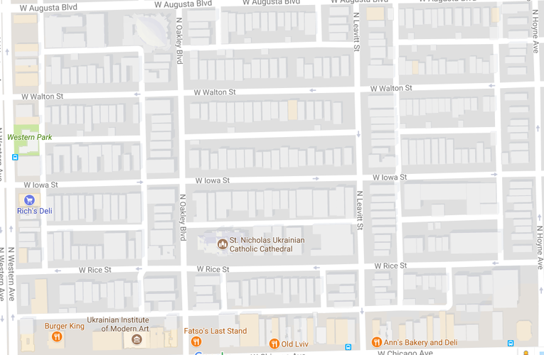
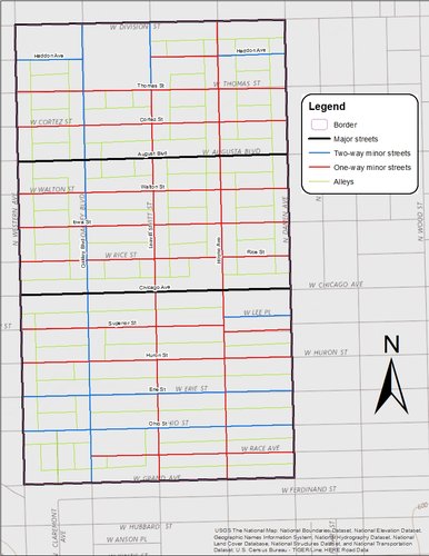
As seen in the above images, Ukrainian Village is entirely composed of east-west ("horizontal") elongated blocks, except for the square superblock where the hospital is located (all the way to the north of the neighborhood). The upper image highlights a section of the neighborhood, and the below image shows that the pattern is consistent throughout the rest of Ukrainian Village. It is interesting to note that these blocks are punctuated by alleys which run both north-south and east-west in some places, forming the H shapes on the map; what appear to be "vertical," north-south blocks only appear so because they are backed by alleys. the blocks as a whole that are bordered by streets on all sides are all oriented east-west..
The above image is also useful for examining the neighborhood's network. Ukrainian Village's streets follow a Savannah pattern, making navigation of the neighborhood extremely easy on foot, though perhaps somewhat less so in a car due to the high number of one-way streets. Also, the high number of alleys (the streets with no name) keeps garbage and garages out of the public realm while making possible increased density through granny flats (though this opportunity is unfortunately underutilized at the moment).
Ukrainian Village is only slightly more varied in terms of thoroughfares type than in block and network type. As seen in the image below, all of the thoroughfares present in the neighborhood fall under the categories of "Street" and "Alley" that are outlined in the Lexicon of the New Urbanism. While it is true that the streets with commercial uses (namely, Chicago Ave., Augusta Blvd., and the streets bordering the neighborhood) receive more vehicle traffic, they are not designed for speed and capacity as are boulevards; similarly, they continue beyond the boundaries of the neighborhood for quite some distance in each direction and are thus not accurately described as avenues either. Thus, I have simply differentiated the commercial streets and more residential streets by labeling them as "major" and "minor" streets, respectively. Lastly, there are many alleys in Ukrainian Village, as is common throughout Chicago.
On the whole, Ukrainian Village is very well connected. More so than many neighborhoods in Chicago, it is truly [forgive me the use of such a phrase] enmeshed in the urban fabric: it is surrounded on all sides by other neighborhoods, rather than by the Lake, the River, or railroad lines. Thus, one can easily walk to or through it from any direction. It is also easy to get from any point in the neighborhood to any other point in it without getting lost, due to the orthogonal grid. While it might be argued that this repetitive grid and elongated blocks make for monotonous walking, the neighborhood is architecturally varied enough that a trip through it on foot is still interesting, and the absence of cul-de-sacs makes one possible. As far as block type, the blocks are short when one is walking in a north-south direction (and if one isn't, there are buses running on the major streets), allowing for many possible routes to any given location (and making Jane Jacobs happy).
The neighborhood’s connectivity is also benefited by types of thoroughfares it contains. Most of the thoroughfares are streets, making walking pleasant and safe even in the commercial “downtown” on Chicago Avenue. The neighborhood also contains a great number of alleys; not all of them connect to each other and so it is perhaps not the most convenient or safest way to get from place to place, they are still helpful in terms of giving residents easier access to their houses or apartments (or otherwise providing shortcuts) while providing a place to park cars other than on the street or surface lots.
One thing that does detract from Ukrainian Village’s otherwise great connectivity is the large percentage of its streets that are one-way. While this may benefit the neighborhood’s residents by calming traffic or reducing the amount of through-traffic, there is no doubt that it would make navigating the area in a vehicle more difficult while also making it more inconvenient to travel through it. While this may only have an effect on motorists and cyclists, it is intensified by the fact that many of the neighborhood’s east-west streets (including Rice, Walton, Cortez, and Erie Streets, among others) terminate shortly beyond the neighborhood’s boundaries, which is inconvenient to pedestrians as well.
On balance, Ukrainian Village is a rather nice neighborhood to live or work in (as perhaps indicated by its recent gentrification as well as its labeling as the “Hottest Neighborhood of 2016” by Redfin, a national real estate company). Though it is somewhat racially homogenous (over 80% of the neighborhood’s residents are white), it has a good mix of housing type and tenure, age (though slightly skewed towards younger residents), incomes, and household types. It has a wide range of shops and services within a 5-minute walk, including grocery stores, pharmacies, and everything else I could think of other than a library, a post office, and a movie theater, all of which are easily accessible in nearby Wicker Park and West Town. It is easily reached by transit, with multiple busses travelling through the neighborhood and the Blue Line nearby. It is easy to get around and an alley network keeps trash and cars off the street. The one area in which I found Ukrainian Village to be lacking, however, was the quality of its public space. Thus, I recommend three specific steps that can be taken to improve the neighborhood’s public realm.
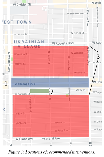
My three recommendations are as follows (the numbers indicate where the interventions should take place, as seen on the map above [Figure 1]): 1) Reduce empty space; 2) Create a park; and 3) Preserve vernacular architecture. I will now discuss each of these recommendations in detail.
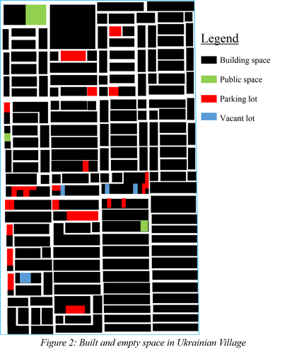
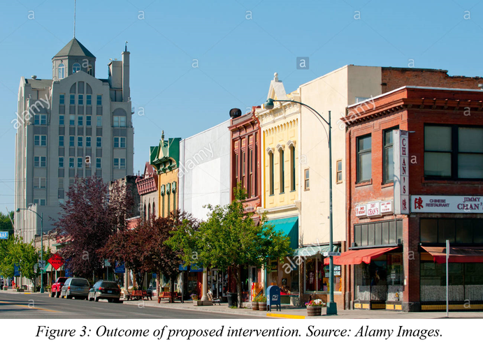
As seen in Figure 2, there are a number of vacant or parking lots in Ukrainian Village. Though these appear throughout the neighborhood, most concerning are those on or near to Chicago Avenue, the main commercial drag of the neighborhood and its de facto center. While the neighborhood is still dense and walkable, this could easily cease to be the case should such dead zones be allowed to dominate. To prevent this from happening and even improve the neighborhood’s vitality, it is imperative that these lots (which are often attached to unappealing uses such as fast-food drive-throughs or used car lots) be replaced with buildings that can attract street life: restaurants, shops, apartments, offices, etc. (Most ideal would be a mixed-use building with shops, housing, and offices.) The outcome of this intervention would be a street scene like that seen below in Figure 3, which is much like Chicago Avenue to the east where fewer parking lots exist.
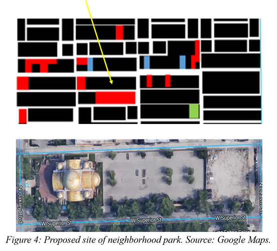
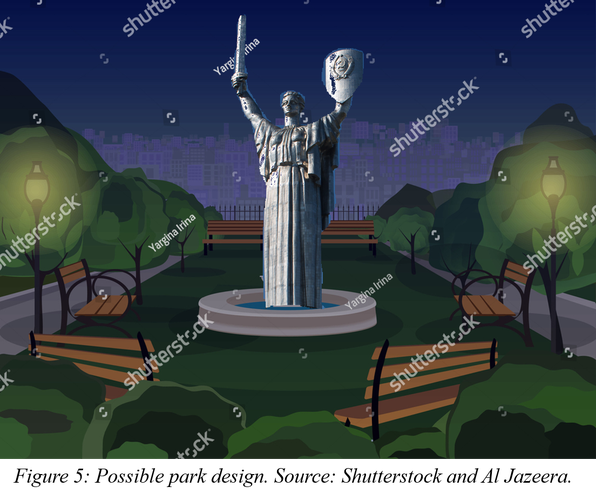
While Ukrainian Village does have some public space, it lacks a real park or square. As seen in green in Figure 2, there are currently three public spaces in the neighborhood, none of which is adequate for an adult population. The larger space, on the neighborhood’s northern edge, is an outdoor seating area attached to Roberto Clemente Community Academy (a high school). Not only is this space somewhat unpleasant and lacking spatial definition, but the area is quite rowdy when school lets out and more elderly residents might not feel comfortable there. The smaller areas are both playgrounds, and as such is not meant for teenagers or childless adults. Thus, Ukrainian Village lacks a true park where all of the neighborhood’s residents can feel welcome; adding one would not only provide a space for recreation but could help foster a sense of community. I propose building one next to the Saints Volodymyr & Olha Church on Superior and Leavitt (Figure 4). This site is appropriate for several reasons. It is large enough to accommodate a neighborhood park; it is centrally located one block away from the neighborhood’s main street; and it is adjacent to what is perhaps the neighborhood’s most notable landmark. The park could take many forms, but I propose something similar to Figure 5, with grass, benches facing a central area, and a centerpiece that reinforces the neighborhood’s history and Ukrainian identity.
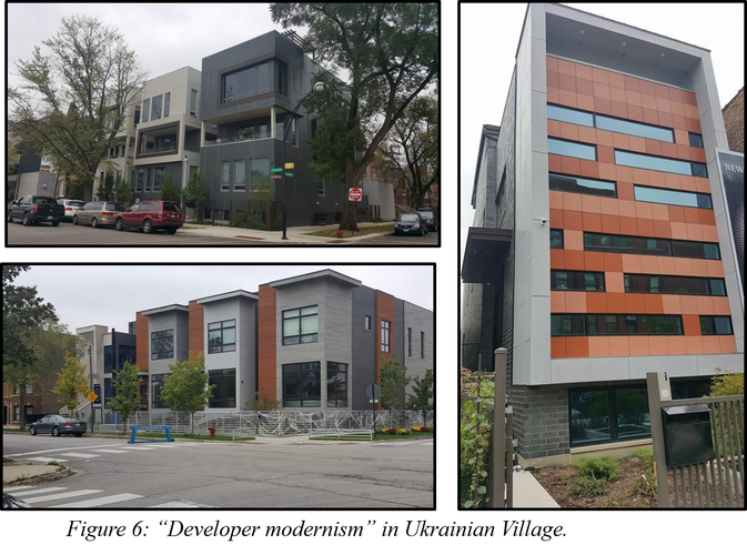
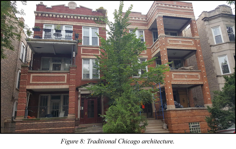
Accompanying the recent influx of young urban professionals into Ukrainian Village has been an increase in the number and audacity of “developer modernist” style townhomes and apartment buildings, such as those in Figure 6. While I do not wish to weigh in on the artistic value of this architecture, I do not think it would be controversial to say that the willy-nilly construction of such buildings has created a somewhat incoherent streetscape in many corners of the neighborhood. Furthermore, the fact that these buildings are primarily home to the newer residents gentrifying the area works against the establishment of a sense of community by acting as a clear visual differentiation of different groups of people who live in the neighborhood. While the preservation of more traditional Chicago-style architecture (Figure 7) is a principle that should be followed throughout Ukrainian Village, the intrusion of the new style is most noticeable in the residential areas highlighted in red in Figure 1.
If all of these interventions are undertaken, I believe that Ukrainian Village will have a better public realm and better serve its residents.
Social Mix
As perhaps evidenced by the above tables, Ukrainian Village is not terribly diverse. While the neighborhood is comparably diverse to West Town, the West Region of Chicago, and the City of Chicago in terms of nativity and place of origin of foreign-born citizens, the neighborhood is still much more white overall (81%!) than the city as a whole. This is perhaps in part because the majority of immigrants to the neighborhood are European or Mexican, whereas the city of Chicago receives many immigrants from Asian countries. (One interesting and related fact I discovered is that significantly more recent immigrants are from Romania than Ukraine, despite the neighborhood’s name.)
Nor is Ukrainian Village remarkably diverse in terms of occupation or age, most likely reflecting the recent influx of young professionals. (See, for instance, the fact that 47% of residents are between 18 and 35 years old, and that 55.5% of working residents work in either “Management, Business, and Financial Operations Occupations” or in “Professional or Related Occupations.”) This large body of young professionals is also most likely responsible for the neighborhood’s relatively greater diversity (compared to the region and city) in terms of mode of commute: young people are less likely to drive to work, and more likely to take public transit, ride a bike, or simply live in areas where they can walk to work. (While multimodality is admittedly an unorthodox measure of diversity, I would argue that it is still an important measure of the degree to which a given neighborhood can attract and accommodate multiple habits and modes of living.)