Overview
Social Mix
Public Space
Amenities
Connections
Final Project
Size
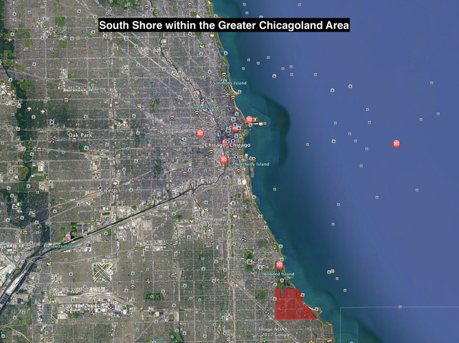
South Shore is home to more than 50,000 residents in about 1,360 acres of land on Chicago’s South Side. [1] As neighborhoods go in Chicago where some range from only a few thousand to hundreds of thousands, this neighborhood is definitely on the larger side of the spectrum despite experiencing sizable population loss throughout the mid-20th and 21st Centuries.[2] It could be described as “like a big high school” considering its pockets of high rises and relatively high population density for Chicago.
[1] Total Population based on Census Tract Data, Social Explorer, 2015. Online. socialexplorer.com
[2] No Author, “South Shore,” Encyclopedia of Chicago, 2005. Online. encyclopedia.chicagohistory.org/pages/1176.html
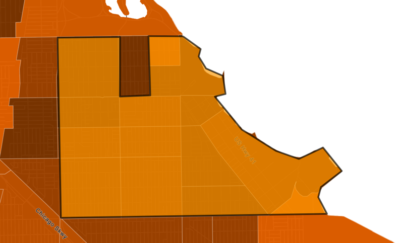
Map generated using socialexplorer.com
Identity
Along the major corridors in the neighborhood, there are signs which are affixed to street lamps that read “Distinctly South Shore” and appear to brand the neighborhood as a cohesive unit that is in some way unique from other places and brings the members of the neighborhood together.
One of its major streets, 75th which cuts through the heart of South Shore has the alternative name “Emmett Till Road” in honor of a black child from this area of Chicago who was visiting family in the South and was brutally murdered for allegedly catcalling an older white female. This road is one of the many memorialization’s in Chicago today of this horrific act and calls among the African American community to never forget this tragedy and the vaster history of violence against blacks in America.
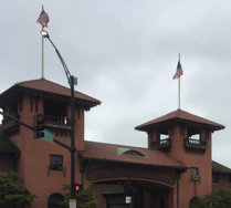
One major social institution in the neighborhood is the South Shore Cultural Center, a country club with a golf course that is owned by the Chicago Parks District and the main clubhouse is used today as a multi-purpose event space, having hosted everything from the Obama’s Wedding Reception to being featured in the movie The Blues Brothers (1980). This institution has a storied past including of fame and exclusion, but today it is accessible for all and often hosts community organized events.
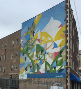
Along some corridors in the neighborhood, one needs only to look up to find stunning displays of public art, like this work by local Chicago-artist Justus Roe, was completed for the South Shore Arts Festival.[1] South Shore with its proximity to Lake Michigan and numerous music-event spaces, seems to have the potential to be bohemian. But, one does not need to look beyond the once bustling New Regal Theater on 79th and S. East End Avenue, in operation from 1927 to 2003 to see the arts potential in South Shore.[2] Now with a new owner, this theater has a newly installed Hologram projector capable of projecting live acts in 3D on stage and re-opened on October 1st, 2017.[3]
[1] No title, Justus Roe 2013.
[2] “South Shore,” Encyclopedia of Chicago.
[3] Sam Cholke, “Regal Theater To Reopen Oct. 1 As A ‘Hologram’ Theater,” dnainfo.com, June 16, 2017. Online. dnainfo.com/chicago/20170616/south-shore/regal-theater-reopen-oct-1-as-hologram-theater
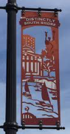
Above photos taken by David Millstein
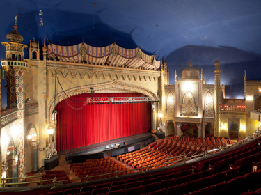
Photo taken by Afterthefinalcurtain.net
Layers
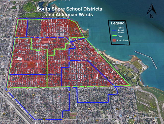
Details:
Layer 1 in Green: Portions of Aldermanic wards 5, 7 and 8 in South Shore
Layer 2 in Blue: Chicago Public School Elementary catchments that are in South Shore
Data
sources:
CPS information from cps.edu/ScriptLibrary/Map-SchoolLocator/index.html
Aldermanic ward information from cityofchicago.org/city/en/depts/doit/supp_info/ward_maps
Diagram
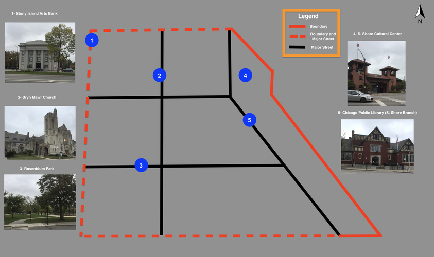
Details:
Six important spaces of South Shore.
History
South Shore is located directly to the south of Jackson Park and probably got its name because of its expansive Lake Michigan coastline and beaches on its eastern border and its proximity south of downtown Chicago. Originally it was a part of the independent Hyde Park township and became annexed by the City of Chicago ahead of the Columbian Exposition of 1893.[1] Dating all the way back to this period, South Shore had its first major real estate boom and its first railroad station was built in its center at 71st and Jeffrey Boulevard connecting the community to other parts of Chicago including downtown.
In the early 1900s, the neighborhood saw an influx of Irish, Swedish, German and Jewish residents. They constructed new social institutions in the neighborhood including churches, synagogues, and community spaces.[2] South Shore was securely middle class and maintained a balanced ethnic diversity throughout the mid-20th Century. Today, South Shore is home to a predominately African American population and maintains many of its strong cultural institutions including the South Shore Cultural Center, the Bryn Mawr Community Church and the Avalon New Regal Theater.
Clarence Perry famously penned the Neighborhood unit in his 1929 essay as a residential district with one school, arterial streets, ten percent dedicated to recreation and park space, local shops, institution sites at the center, and an internal street system.[3] Does South Shore live up to this standard? Somewhat. It has pockets between major arterial streets like 67th to 71st and Stony Island Ave to Jeffrey Boulevard which could resemble Perry’s idealized residential district. But, whether South Shore lives up to the Perry archetype, does not necessarily mean it was designed completely haphazardly.
Its major commercial corridors seem relatively well laid out, including Stony Island Ave. along the western border, 71st street going east-west, Jeffrey Boulevard going north-south through the center of South Shore and Exchange Pl. cutting diagonally in the eastern portion of the neighborhood. Dotted with stores, churches, and some restaurants, South Shore has a variety of businesses, but not to an overwhelming degree. Going down one of its side streets, one feels immediately transported to the suburbs. Many units have large street-facing lawns and trees lining the streets making these residential corridors ideal for managing the craze of urban life.
Additionally, if we look to Thiis-Evenson’s discussion of a neighborhood, we learn about ways in which a neighborhood can delineate its borders: boundaries, tracts, and focuses.[4] South Shore has many natural boundaries with Jackson Park to the north and Lake Michigan to the east. Further, Stony Island Ave. to the west and 81st Street to the south are large arterial streets which help to give South Shore more of a unique spatial identity. With these considerations, South Shore has effectively delineated itself from its adjacent neighborhoods of South Chicago and Grand Crossing.
But despite these delineations, there are areas for improving the cohesiveness of the neighborhood. To start, many of the major commercial corridors have street-facing empty lots, parking lots or vacant spaces. Filling in these shops and revitalizing the economic vitality where there is heavy foot traffic, public transit bus, and train stops, and constant car traffic can bring more money flowing into the neighborhood's economy. With the Obama Presidential Library coming to Jackson Park, directly north of South Shore, the new economic activity may also be coming to the area. Even just by knowing the history of the area and the feats of its past, it is reasonable to expect that South Shore will grow again in the years to come.
[1] “South Shore,” Encyclopedia of Chicago.
[2] “South Shore,” Encyclopedia of Chicago.
[3] Clarence Perry, The neighborhood unit. Regional Plan of New York and its Environs, 1929.
[4] Thomas Thiis-Evenson, Archetypes of Urbanism. Oslo, Norway: Scandinavian University Press, 1999.
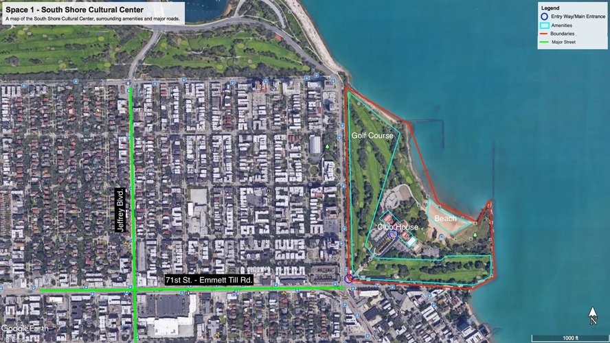
This section explores the usage of public space in South Shore. The two case studies used are the South Shore Cultural Center at 71st/Exchange Pl. and the S. Merrill Community Garden on S. Merrill Ave. btw 70th and 71st St.
The South Shore Cultural Center is located at the intersection of 71st St., Exchange Pl., and South Shore Drive. Nestled along the coast of Lake Michigan between 67th and 71st Street on one side, the adjoining two street-facing borders have walls running along the massive, 67-acre self-contained property. These rigid boundaries appear to prevent the space from feeling open and welcoming to the surrounding community. One interpretation of these facts is this space reflects what Carmona calls an exclusionary space because it has physical barriers that seem to separate it from outside. As you approach the main, and only, entrance to the grounds, only a sign that reads “South Side Cultural Center” gives you any cues about what lies behind the gate. Only after a long stretch of road lined with trees and scarce sidewalk, does one reach the clubhouse’s main entrance with no signage about whether the facility is open or closed. Only once inside are there informational flyers and signage about the events and activities that take place inside. Today, the property is managed by the Chicago Parks District and is open to the public. It features a nine-hole golf course, a beach, and a restaurant on the premises, but little can be discerned from outside the premises. But unless there is better advertising online or just strong word-of-mouth about the space, one would have difficulty from physically seeing it as a public space.
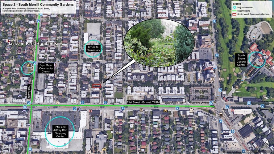
The South Merrill Community Garden is located between 70th and 71st St. on S. Merrill Ave in the heart of South Shore. What immediately stands out about this space is how it is located close to major amenities in the neighborhood just outside of its space. While much tinier than the South Shore Cultural Center, it is dependent on these outside amenities to ensure its vitality. Specifically, the close proximity of the Bryn Mawr Community Church, O’Keeffe Elementary School, the 71st and Jeffrey Blvd Shopping Center and the Bryn Mawr Metra Stop. This space reflects a community space that appears in Carmona's terms neither exclusionary nor scary. Its closeness to these community resources range from transit to shopping to education but also contributes to the geographical importance, that people are constantly circulating on the nearby streets around the garden. As related websites tout, school children can go to the garden to learn about urban farming, community members can learn new skills, help with its upkeep, and meet other members of their community there, and the garden also can share fresh produce with residents of the area. Most importantly the garden serves as an urban oasis of sorts, a joint venture that community members are invested in together and can go to for a temporary escape from city living.
Maps generated in this section were made using Google Earth.
Work used: Matthew Carmona, "Re-Theorising Contemporary Public Space: A New Narrative and a New Normative." Journal of Urbanism: International Research on Placemaking and Urban Sustainability 8, no. 4 (2015): 373-405.
The graphs and maps below show the number of and disbursal of amenities across South Shore and denoting whether these amenities are locally or corporate owned:
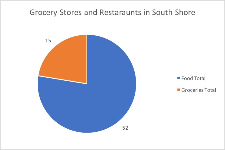
South Shore has a wide variety of food options with over 50 establishments in the area and also has a handful of grocers, few of which are big-box stores. This information can be seen in the graph below.
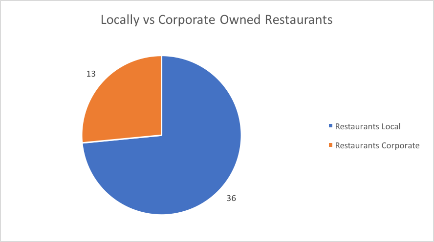
The chart below shows the breakdown of locally and corporate-owned restaurants.
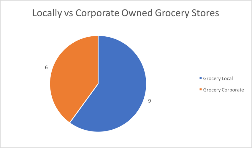
The chart below shows the breakdown of locally and corporate-owned grocers.
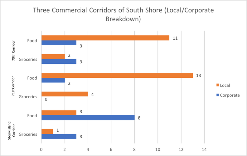
The chart below further breaks down the local and corporate ownership into three sections or commercial corridors of the neighborhood: Stony Island Ave, 71st and 79th Street.
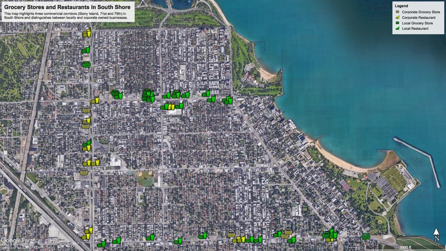
The map below displays all restaurants and grocers along the three corridors mentioned earlier.
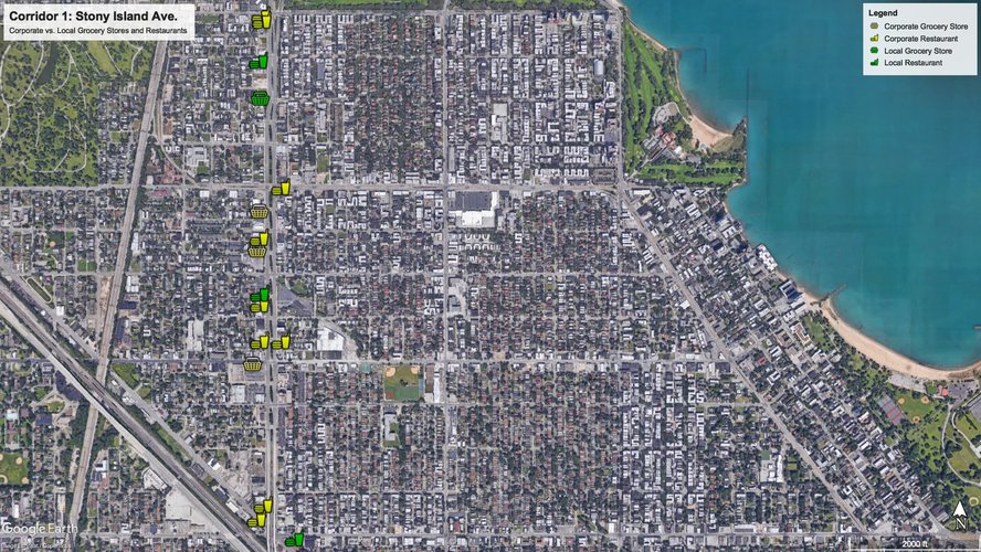
The map below shows a detailed display of amenities along Stony Island Ave.
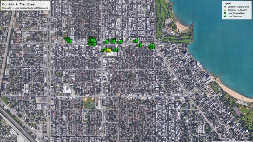
The map below shows a detailed display of these amenities along 71st Street.
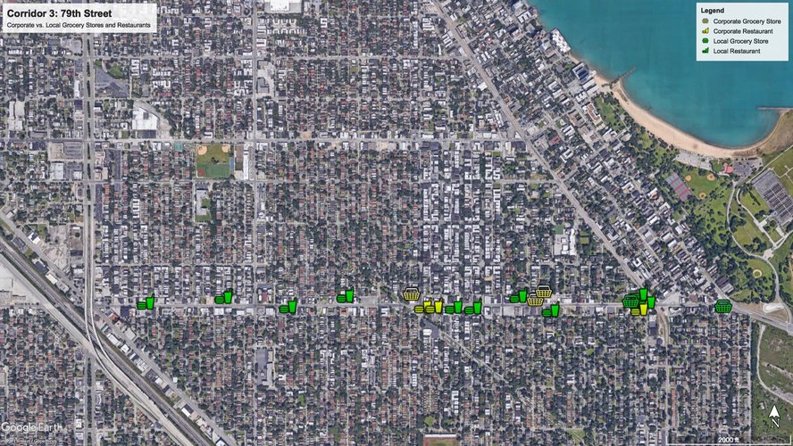
This map shows a detailed display of these amenities along 79th Street.
South Shore has a variety of amenities for its residents, but it is worth distinguishing between the locally- and corporate-owned to gain insight on how these amenities fit within the context of their community. Two kinds of amenities that can tell us a lot about the share of both types of ownership are groceries and restaurants. These amenities can tell us about the behaviors and preferences of residents and how successfully local businesses can thrive in a community.
In terms of the specific breakdown between local- and corporate-ownership, South Shore has 27% corporate-owned restaurants and 73% locally-owned restaurants. Meanwhile, for grocers, there are 40% of corporate-owned grocers and 60% that are locally-owned. These results at face value may be hard to decipher in exploring questions about whether the local community actively supports locally-owned businesses or the effect of corporate-owned businesses on locally-owned.
Segmenting the neighborhood into three commercial corridors can help to attain more detailed observations to attempt to answer these questions. When segmentation happens, we generate much clearer results. Stony Island Ave supports the largest number of corporate-owned restaurants (8) and tied for the most corporate-owned grocers (3). Since Stony Island Ave also acts as a western border for South Shore, it is reasonable to conclude that these businesses are drawing people from South Shore and other surrounding neighborhoods to these establishments. It appears that locally-owned businesses have struggled on this avenue since there are very few locally-owned restaurants (3) and grocers (1) operating on it.
71st and 79th Street which run through South Shore paint a very different picture. Both streets sustain a large number of locally-owned businesses, with greater than ten local restaurants on each street. They also have a combined six locally-owned grocers compared to Stony Island, which has only one. This data shows the greater strength of these commercial corridors to supporting local businesses, and may partially be due to the central and walkable locations of these businesses in the heart of South Shore, while still continuing to survive despite corporate businesses co-existing too. Ultimately this interpretation of South Shore's amenity distribution presents the possibility of a geographically dependent conception of where local businesses in the neighborhood thrive. The answer for local businesses is major street corridors that run through the center, whereas corporate-owned businesses tend to locate on the peripheries to find greater success.
Maps generated in this section were made using Google Earth.
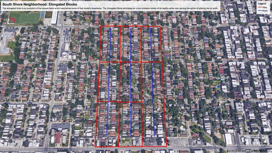
Elongated Blocks
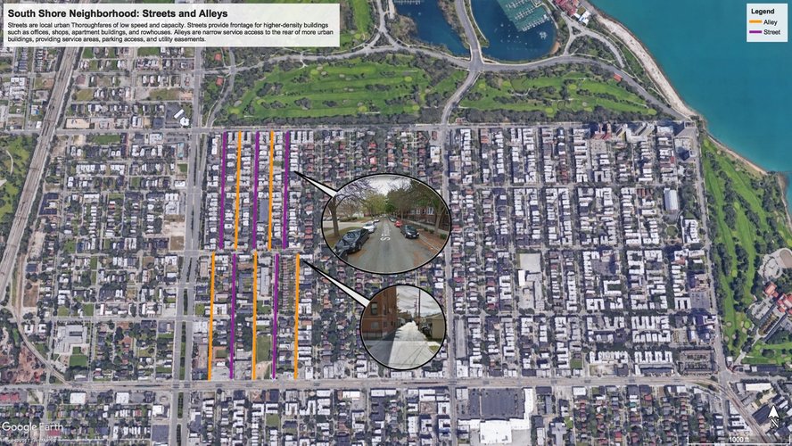
The map above shows that South Shore is composed of mainly elongated blocks. On the short side, there are often commercial businesses. On the longer edges, there are mainly residential units. In between each block are alleys that provide quick and efficient access for essential daily servicing of the neighborhood, such as garbage disposal and pickup, maintenance work, places for kids to play safely.
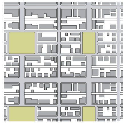
Savannah Pattern
The diagram above shows a typical layout of the Savannah pattern, which can be seen implemented throughout most of South Shore without the public squares that are present above. The main features of this design include well-organized, straight roads that are easy to navigate. However, these areas typically have difficulty regulating traffic making them for pedestrians somewhat more dangerous crossing streets.
This image is taken from The Lexicon of New Urbanism (2014), page 25.
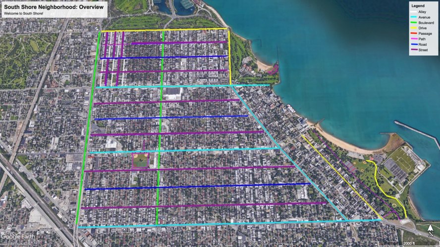
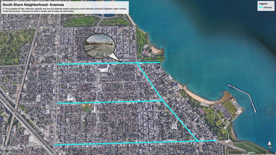
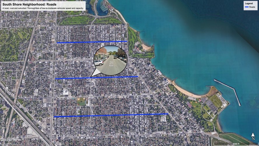
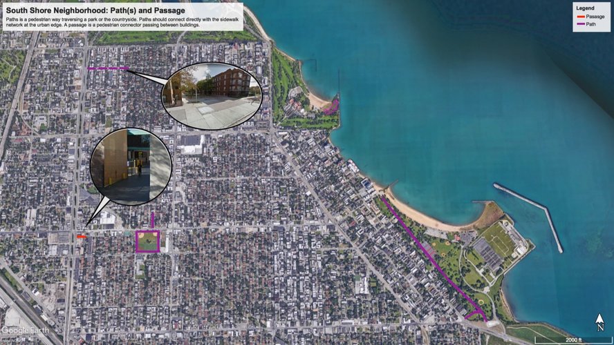
Overview of street-types in South Shore
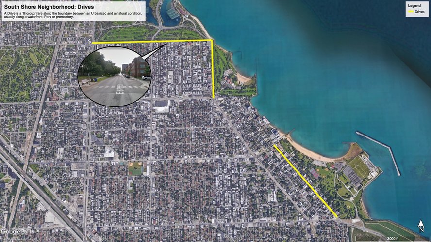
Drives
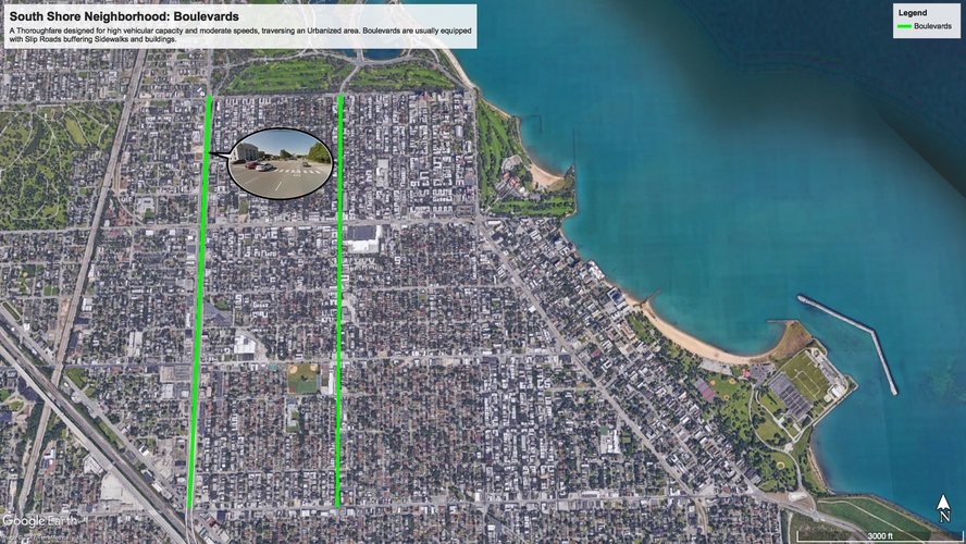
Boulevards
Avenues
Roads
Sample of Streets and Alleys
Pathway(s) and Passage
Connectivity Analysis
At face value, South Shore appears like many other community areas in Chicago. Its range of street-types provide a variety of options for cars and people to move around. There is clear delineation between calmer, residential corridors and busier, main arteries bringing cars quickly through or around the neighborhood. But, having boulevards like Stony Island Ave and Jeffrey Boulevard does not sacrifice for pedestrian friendliness. Large sidewalks along 67th Street and South Shore Drive make for natural running paths or dog walking routes unobstructed by streets bisecting them. There also appears a relatively systematic dispersal of mid-sized Avenues at 71st, 75th and 79th Street, which host many of the neighborhood’s businesses, transit stops, and amenities.
Traffic going into these arteries are controlled in multiple cases by cul-de-sacs on side-streets that cut-off before intersecting with them. These features limit the number of streets flowing into the avenues and lessens the impediment on traffic flow along them, while not limiting the pedestrian flow on these side-streets. These lower speed streets may also foster closer connections between residents, because less car usage can encourage people to make greater usage of the space outside their homes and helps residents to reclaim the immediate space around them from cars, which have taken over many other parts of the city already.
Another unique feature of South Shore is the 68th Street pedestrian pathway that is continuous for many blocks between Stony Island Avenue and South Ridgeland Avenue. This space can provide additional areas for connectivity between neighbors, friends to play games outside, or strangers sparking conversations on a nice day outside. Unlike a park, this type of space is much more integrated with its surrounding and can lead to more meaningful neighborhood connectivity than a distant neighborhood park, like Rainbow Beach Park in the southeast corner of South Shore.
The Victoria Transport Policy Institute has laid out its own standards for street connectivity including limiting maximum block size to 5-12 acres, limit cul-de-sacs (no more than 20%) and limit the maximum length of cul-de-sacs to 400 feet. Most of these requirements for connectivity are met by South Shore. For instance, the average block size is 5-6 acres. Additionally, fewer than 20% of streets are cul-de-sacs, it’s probably closer to 5%. Lastly, the cul-de-sacs are about 500 feet long, but since the streets are straight, it is easy for a driver to pick out which streets are continuous into the larger arteries and which are not. These findings support my conclusion that South Shore has many attributes that help to enhance connectivity.
These maps were generated using Google Earth. Descriptions for each come from The Lexicon of New Urbanism (2014), an online version of which can be found here.
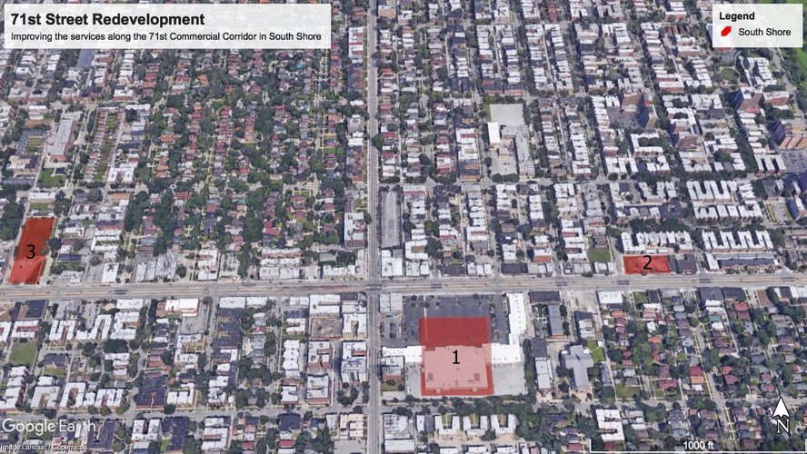
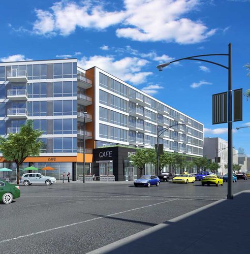
My research into South Shore this quarter has shown that there are both coveted amenities–the South Shore Cultural Center and the Stony Island Arts Bank–as well as, challenges stemming from vacant lots and boarded-up storefronts that plague communities across the South Side. My proposed solution to address these problems in South Shore focuses on redeveloping the 71st Street Commercial Corridor through three new ideas: (1) A multi-purpose South Side Food Market in the former Dominick’s location at 71st and Jeffrey Boulevard, (2) A mixed-use residential complex at 71st and S Paxton Ave to offer affordable housing options and new retail space, and (3) A community park at 71st and S East End Ave that can offer South Shore residents a venue to host community programming and events.
Image 1: South Shore 71st Redevelopment Proposal
Intervention 1: South Shore Food Market
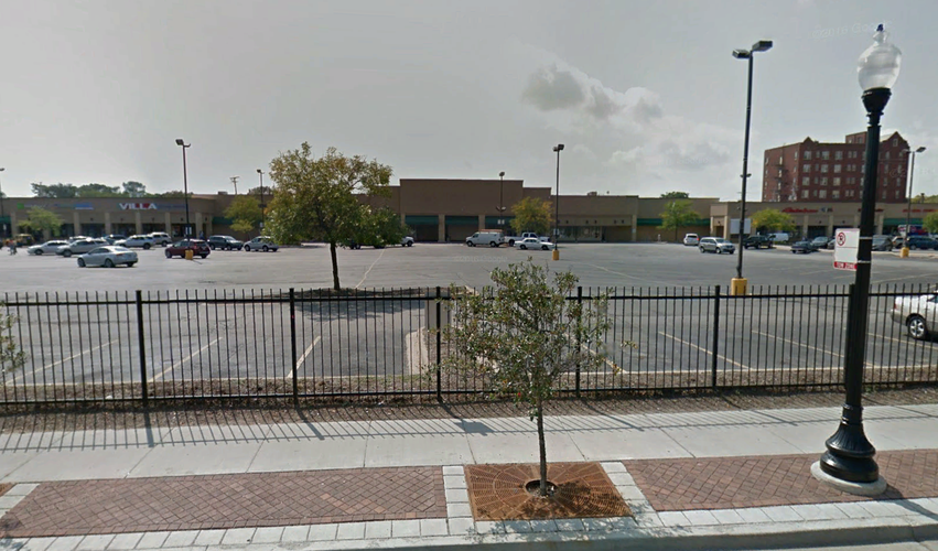
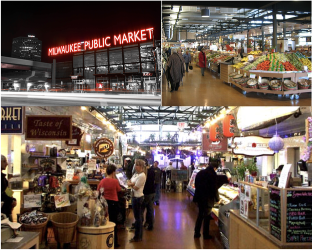
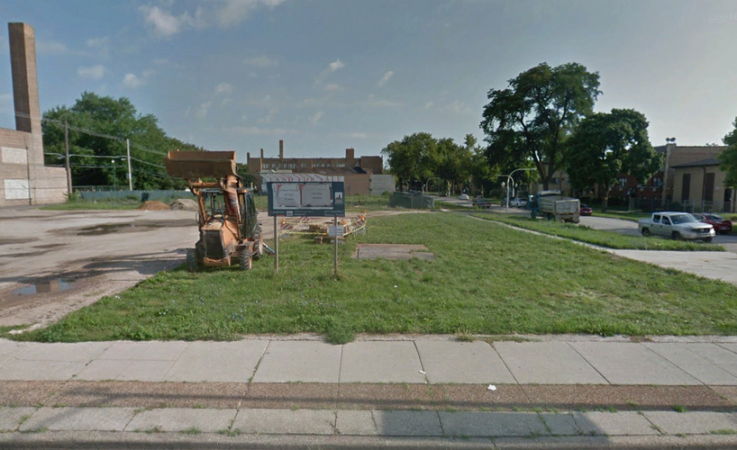
Three years ago, Dominick’s South Shore location closed its doors. This closure ended the tenure for the community’s only “full-service” grocery store. Today, Jeffrey Plaza on 71st Street still has this storefront empty and has struggled to attract a new grocer to take the space over.1 While South Shore has many small corner-grocery stores, it lacks the offerings of fresh produce and poultry that a “full-service” grocer can provide.2 My intervention is to repurpose the former grocer’s space, rather than a replacement, to create a “South Shore Food Market Hall” similar to the Milwaukee Public Market instead (Pictures Below). The Public Market in Milwaukee features fresh produce and meat, areas for dining in and wide walking corridor for customers. Creating a similar kind of market in South Shore could serve as an anchor for local businesses that face pressures from gentrification. Meltzer argues that “less vibrant neighborhood retail markets could be more vulnerable to gentrification-induced displacement.”3 While gentrification may not be as apparent currently present in South Shore, the construction of the nearby Obama Presidential Library has spawned major real estate speculation in Woodlawn and could extend to South Shore too.4 Having this new project as an anchor in the Jeffrey Blvd Shopping Center will promote small, locally and minority-owned businesses in the area and become more resistant to potential displacement.
Image 2: Current Empty Storefront in Jeffrey Plaza
Image 3 (Top left), Image 4 (Top right), Image 5 (Bottom): Interior and Exterior of the Milwaukee Public Market
Intervention 2: Increasing Housing Density
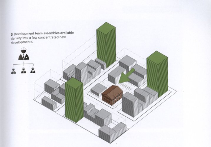
South Shore has a housing stock that includes a majority of 9 or less attached units and very few high-rise apartment complexes.5 But, selectively increasing the housing density in South Shore can increase the diversity of housing options for its residents and support greater socio-economic diversity. Constructing a mixed-use 80-unit residential and retail building on the vacant lot at 71st and S Paxton Ave could help serve some of South Shore’s current needs and as a catalyst for further development on the eastern underdeveloped strip of 71st street. Chakrabarti argues that building hyperdensity in neighborhoods can “improve the neighborhood by enhancing the quality of housing options for its residents.”6 Adopting theories that he proposes on hyperdensity, South Shore can preserve its small-town charm feel, while also better enabled to meet the needs of its residents. Below is one diagram from Chakrabarti that shows how selective hyperdensity can be implemented effectively. On the street level, local stores can move-in with access to modern amenities that will help it attract new enterprises and customers. The higher floors can feature a mix of smaller studio and one-bedrooms that can appeal to lower middle-class renters, and two- or three-bedrooms that can appeal to wealthier individuals.
Image 6: Selectively building hyperdensity model
Image 7: Model development in Bucktown with storefronts on street level and apartments above
Intervention 3: Community Park and Event Space
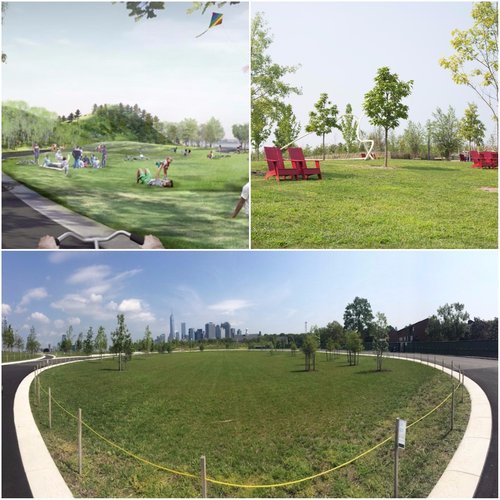
Public space and services can often go hand-in-hand, in so far as, a public space can serve as a vital service for a community. Southworth suggests that “vibrant public life often occurs in banal largely undersigned spaces such as vacant lots, empty parking lots and disused alleys or streets.7 But still suggests that space does need vital “programming” and to engage many actors in the creation and activation of urban space.”8 The activation of the currently vacant 71st and S East End Ave lot for the South Shore community by adding lawn chairs, walking paths, a performance stage, sculpture gardens can bring to life this space, through Southworth's suggestions, in the heart of South Shore. Modelled off of the Governor’s Island Park shown below, simple additions and arrangements can be crucial additions for a community to fully be able to take advantage of. Additionally, community members and organizations should be included to decide how this space will be used. This would add a community park to an area of South Shore replete with any and be in close proximity to a local elementary school, the Stony Island Arts Bank, and the 71st Commercial Corridor as well. This development will ensure that many have access to green space and the opportunity for residents of South Shore to help shape the environment around them.
Image 8: Current "for-sale" lot at 71st and S East End Ave
Image 9 (Top left), Image 10 (Top right), Image 11 (Bottom): Images of Governor's Island Park
Conclusions
The suggestions above will lead to a more vibrant 71st commercial corridor and many enhancements to help South Shore prosper in the future. These changes address key services that are currently missing from the area and the addition of which will have major immediate benefits for the residents in the surrounding area. Similar proposal could also be made to the Exchange Pl. and 75th Street corridors as well.
Notes
1 Sam Cholke, “Hariston Says 71st Does Not Need Another Dollar Store, So She’s Rezoning It”, DNAInfo.com, May 3, 2017. Online.
2 Analysis based on Google Maps information of businesses in South Shore. There are 15 grocers in South Shore, but only one “full grocer” on Stony Island Ave., which is not considered within the boundaries of South Shore.
3 Rachel Meltzer, “Gentrification and Small Business,” Cityscape: A Journal of Policy Development and Research 18:3 (2016), 80.
4 Sam Cholke, “Woodlawn Home Values Soar As Obama Library Draws New Interest To Area,” DNAInfo.com, September 12, 2017. Online.
5 Analysis based on information provided by Social Explorer. See Social Mix page of Hood Mapping for South Shore to explore this data further.
6 Vishaan Chakrabarti, A Country of Cities: A Manifesto for an Urban America, New York: Metropolis Books, 2013, 135.
7 Michael Southworth, “Public Life, Public Space, and the Changing Art of City Design,” Journal of Urban Design 19:1 (2014), 37.
8 Southworth, 39-40.
Image Sources
1 Generated using Google Earth
2 Generated using Google Earth Street View
6 Chakrabarti, 151
8 Generate using Google Earth Street View
Social Mix
The information below represents certain demographic information about the South Shore Neighborhood including gender, race, education, housing stock, value and tenure.
South Shore is a vibrant, while still economically resurging neighborhood on the South Side. It is a primarily African American neighborhood, as its low 1.143 for racial diversity based on the Simpson Diversity Index suggests, but race is not the only way one can measure the diversity of this neighborhood. Typically, a low score shows less diversity and a score that is high, relative to the number of categories for a variable, shows more diversity. We can consider South Shore’s high score of 5.998 for housing type diversity out of an 8-possible score using the same index showing a wide variety of housing types. This is an interesting finding because it shows that South Shore can support residents of a variety of income, richer residents can buy single unit houses, while poorer residents may be able to afford a one or two-bedroom unit in a larger apartment building creating the potential for a vibrant mix economically in its community. This also corresponds to the early ideas for “the Neighborhood Unit” that Clarence Perry might have had, and would suggest the ability for South Shore to support local shops and other businesses.
We can also look at the 9.767 score for age diversity to show that the neighborhood is not dominated by a single age group, catering to young and old people alike, which is important to creating a strong community. This is largely because these groups are attracted typically to different amenities, so it is likely that South Shore has enough variety to attract both groups. It also means perhaps that people who grew up in the area are likely to stay, which shows potentially a large access to opportunity and a strong identity or affinity to the area by the residents. This would also suggest the growth of strong community institutions because residents invest in and support them.
Data from socialexplorer.com
If you would like more information on the data used click here.