Overview
Social Mix
Public Space
Amenities
Connections
Final Project
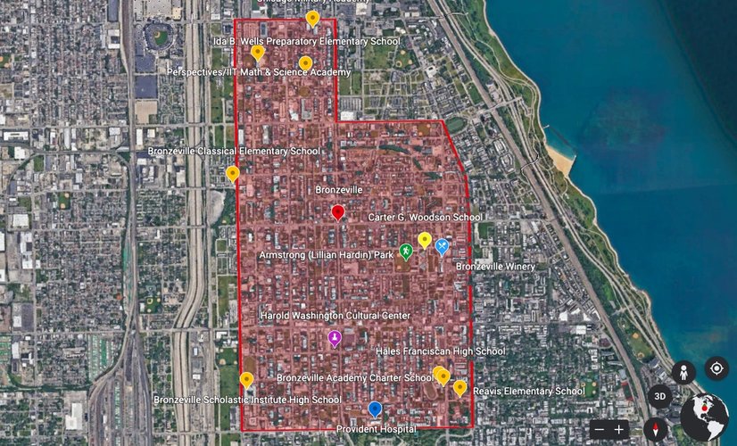
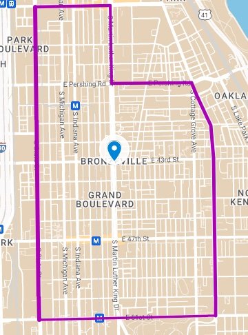
Bronzeville is a relatively large South Side neighborhood. The majority of the geographic area is contained between Pershing Ave and 51st St (from North to South), and S State St to Drexel Blvd (West-East). However, the full neighborhood stretches all the way North to I-55, with the width narrowing the further North one goes. The full neighborhood appears as so:
**Shading is for diagram purposes only
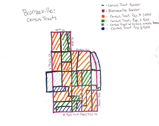
For the purpose of this project, I will focus on the boundaries described above with the inclusion of a patch that extends up to 35th St and is bounded by S MLK Dr on the East as shown in the image below:
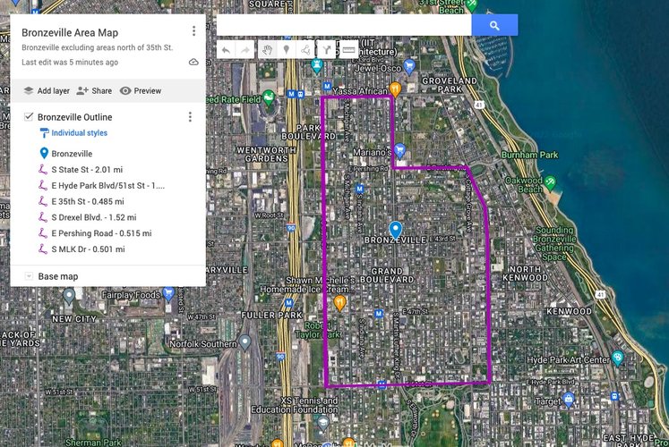
This chosen portion of Bronzeville contains 1.98 square miles of land, or about 1,267 acres. According to Social Explorer, the population of Bronzeville contained within these borders is approximately 28,000.
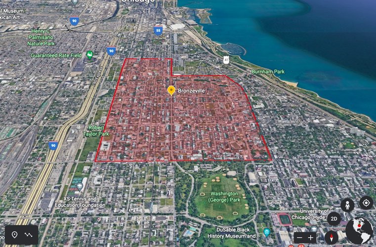
3D Map of Bronzeville
Bronzeville is marked by strong borders in the form of streets, some more aesthetically pleasing than others. E Hyde Park Blvd/51st St borders the neighborhood to the south, with Washington Park creating a strong southern border between S Martin Luther King, Jr. Dr and S Cottage Grove Ave. In this way, the north side of Washington Park acts as a gateway into Bronzeville. To the east, between E Hyde Park Blvd. on the south and E Pershing Rd. on the north, S Drexel Blvd. forms an aesthetically pleasing border. Upon crossing the 51st St border, Drexel becomes a boulevard with a large green space divindig the two directions of traffic. This beautiful green space spans about 1.5 miles, with paved walkways through the greenspace where I saw people walking their dogs, riding bikes, or simply taking an afternoon stroll. Drexel Boulevard turns around before it intersects with Pershing Rd, with a fountain marking the end of the Boulevard.
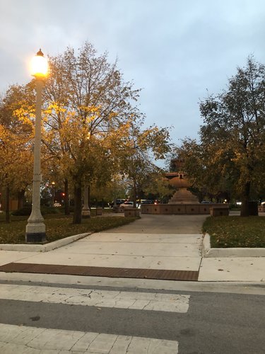
Drexel Boulevard, facing northern end of boulevard. Fountain cuts off connection to Pershing.
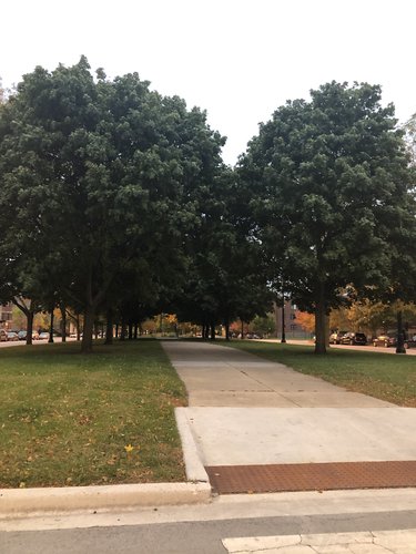
Drexel Boulevard, facing South on turn around
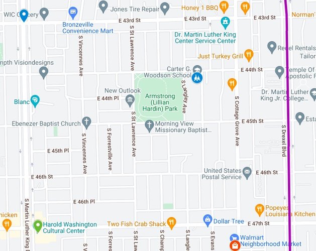
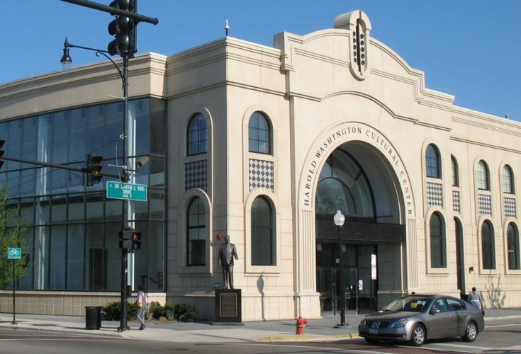
While not having one central commercial corridor, Martin Luther King, Jr. Dr does act as a central passageway through the neighborhood, with important cultural institutions such as the Harold Washington Cultural Center, on the southwest corner of MLK Dr and 47th St. The Harold Washington Cultural Center also acts as the closest thing to neighborhood center. Despite its location in the southern part of Bronzeville, this cultural, performance, and event space hosts several community events, including open mics hosted by the famous Chicago rapper Chance the Rapper’s nonprofit, Social Works.
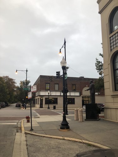
Despite lacking any central commercial corridors, Bronzeville has plenty of smaller commercial corridors. 47th St, west of Martin Luther King Dr, represents one of the most important commercial corridors, with a beauty supply store, nail salons, a merchandise shop, a liquor store, restaurants, and other businesses clustered around the CTA Green Line stop on 47th. Similarly, Pershing Rd also has a small commercial district between the end of Drexel Boulevard and Martin Luther King, Jr. Dr. Finally, Cottage Grove Ave represents some of the most important commercial investment into the neighborhood. On the intersection of 47th St and Cottage Grove are modern looking apartments on top of business centers, with a Walmart sitting just south of this intersection on Cottage Grove Ave. The Bronzeville Winery, which opened its doors in April of 2022, sits a little further north, between 45th and 44th St. Outside of these small commercial corridors, however, Bronzeville is largely residential, perhaps epitomized by the fact that there are over 9 schools in the area (both elementary and high schools). The architecture of the residential areas is largely similar in older brick buildings that can serve either as multi-unit or single family homes. Along Martin Luther King, Jr. Drive, however there are a few high-rise buildings that serve as large apartment buildings.
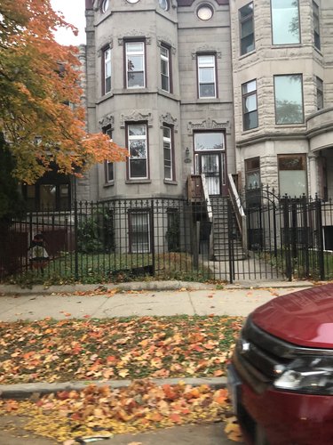
Multi-unit/single family homes on Drexel Blvd
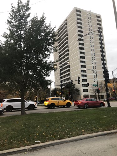
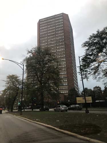
High Rises along Martin Luther King, Jr. Drive.
Bronzeville is a neighborhood with a rich history that can be traced back all the way to the Great Migration. A few decades after slavery was abolished, many Black people moved from the South and settled in Northern cities in hopes of finding greater economic opportunities and escaping the Jim Crow South. In Chicago, the settlement of Black people that moved North was known as the “Black Belt”, as it was a highly segregated portion of the city that was largely African American. As people continued to migrate into the area, Black-owned businesses began to establish themselves, leading to the Golden Age of Bronzeville between the 1920s and 1940s. The neighborhood was home to two important Black newspapers, The Chicago Bee and The Chicago Defender, as well as other cultural institutions, such as the Regal Theater. The neighborhood got its name from a theater editor at The Chicago Bee, James Gentry, who wrote that Black people’s skin color more closely resembled Bronze than Black, hence the name “Bronzeville”. Many other famous and culturally important Black Americans spent important years of their lives in the Bronzeville neighborhood, including Civil Rights activist Ida B. Wells, poet Gwendolyn Brooks, and author Richard Wright. The importance of Bronzeville to Black American history is vital, it was Chicago’s very own version of Harlem during the same era, and it produced some of the most important advances in arts, literature, and culture in that era. This extended to the business sector of the neighborhood as well. There were several small commercial districts in Bronzeville, including “The Stroll,” a two-block district filled with, food, jazz clubs, and lights. Day or night, people would crowd the “The Stroll” in part because a large portion of the Black population in Chicago resided within this “Black Metropolis.” However, after World War II and the economic divestment from the cities into the suburbs, many middle-class families left Bronzeville. Today, people are attempting to revitalize the area, with it being designated as a priority community as part of Mayor Lightfoot’s INVEST South/West commercial initiative.
“Bronzeville.” n.d. City of Chicago. Accessed October 17, 2022. https://www.chicago.gov/city/en/sites/invest_sw/home/bronzeville.html.
“Bronzeville: A History of Chicago’s Bronzeville Neighborhood - 2022.” 2022. MasterClass. https://www.masterclass.com/articles/bronzeville-history.
“The History of Bronzeville | Chicago Studies | The University of Chicago.” n.d. Chicago Studies. Accessed October 17, 2022. https://chicagostudies.uchicago.edu/bronzeville/bronzeville-history-bronzeville.
“The Incredible History and Cultural Legacy of the Bronzeville Neighborhood.” 2016. Chicago Detours. https://chicagodetours.com/bronzeville-neighborhood/.
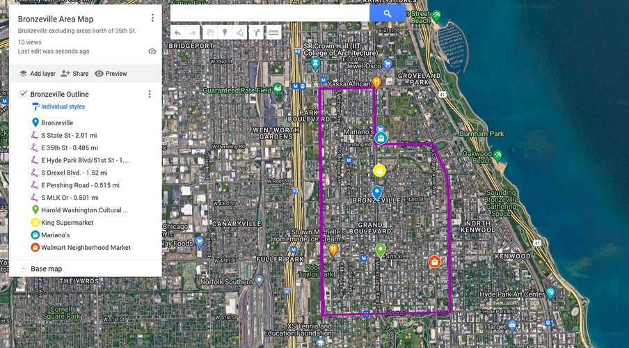
As has been previously mentioned, Bronzeville is a very large neighborhood. It encompasses an area of nearly 2 square miles. When thinking of the “15-minute city,” Duany and Steuteville write that there are 3 different “shed levels,” the first of which is “The 5-minute walk shed, a quarter-mile from center to edge, indicating the individual neighborhood. Each quarter-mile shed must have ordinary daily needs, a range of housing types, and a center (generally a public square or main street with minimal mixed use)” (Duany and Steuteville 2021). Bronzeville itself could encompass multiple walk-sheds, leading to the question of if it is too big to be considered just one neighborhood. This can be interrogated even more when looking at the services that are provided within the 5-minute walk shed, which roughly translates to an area within a quarter-mile radius.
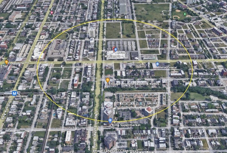
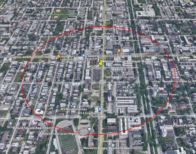
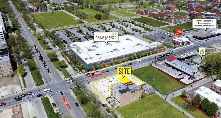
One important service that should be readily available within all 5-minute walk sheds is the grocery store. In this regard, Bronzeville is severely lacking. As we can see in the map above, Bronzeville is home to two big-chain grocery stores, a Walmart Neighborhood Market on 47th St and Cottage Grove Ave, and Mariano’s on the outside edge of the neighborhood on Pershing Rd and King Dr. Additionally, there is a small grocery store on King Dr and 41st St called King’s Supermarket. However, all three of these grocery stores present their own issues. To start, despite advertising itself as a grocery, King’s Supermarket functions more as a glorified convenience store, with a small selection of products and high prices. This is even more troubling once you realize that the store is located at the bottom of a senior living apartment complex. Despite advertising that they accept EBT/SNAP benefits, many people complained in Google reviews that they were denied the ability to pay with their LINK cards. Additionally, King’s Supermarket is the only grocery store actually located in the central corridor of the neighborhood (Martin Luther King Drive). Fortunately for the residents of this senior living apartment complex, the Mariano’s is also on King Drive, and within their own 5-minute walk shed. Unfortunatley for other Bronzeville residents, the Mariano's is located right outside the bounds of Bronzeville, while Walmart is located near the east edge of the neighborhood. Perhaps because they are large chains, they are meant cater to surrounding neighborhoods as well due to the car traffic that passes by them. However, with regard to walkability, the placement of these grocery stores leaves many residents of Bronzeville without walkable access to a grocery store.
While their are many residents within Bronzeville that could benefit from grocery stores that are a walkable distance from them, this does not mean that those grocery stores do not serve large populations of people who could only reach these grocery stores by foot. Using Social Explorer, I was able to estimate that 6,251 people can reach the Walmart Neighborhood Market by foot. This number is comparable to Mariano’s 6,185 people. To residents of Bronzeville, I would say both are about equally accessible by foot. However, Mariano’s does contain a huge parking lot on the east side of King Drive that removes some of this accessibility from people who live farther north in Bronzeville. At the same time, there are more high-rise apartment buildings located near Mariano’s. While this speaks positively to the density in the Bronzeville area of Chicago, the rest of the neighborhood residents deserve walkable access to grocery stores as well.
5-minute walk shed (quarter-mile radius) around Mariano's
5-minute walk shed (quarter-mile radius) around Walmart Neighborhood Market
This aerial view shows the large parking lot and empty space immediately next to the Mariano's. Image does not show high-rise apartment buildings north and south of the Mariano's (out of the frame)
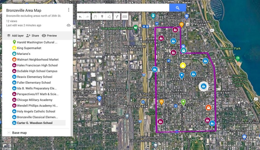
Another daily service that is vital to the healthy fabric of a neighborhood is the schools. In this aspect, Bronzeville has much more to offer, as the following map shows.
Schools are indicated with icons of two people walking to school. Blue icons indicate elementary schools. Burgundy icons indicate Middle and/or High Schools
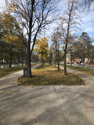
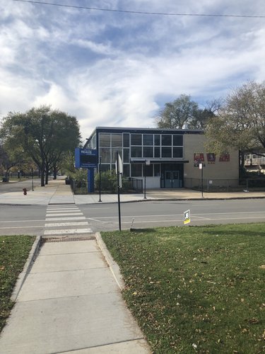
As we can see from the map above, Bronzeville has a much wider array of options when it comes to education for its residents. There are twelve schools servicing the neighborhood, with five middle/high schools and seven elementary schools. These include a variety of school types as well, with public, private, and charter schools all servicing the neighborhood. Most of these schools are accessible by walking routes, although the ones that are placed near the edges of the neighborhood are closer to busier streetways that might be hard to cross for children without adult supervision. On the east edge of the neighborhood, however, with Drexel Boulevard as the boundary, the boulevard green way presents a walkable path to several schools, such as Reavis Elementary.
Green space on Reavis Boulevard facing North between 51st St and 50th St
Path from Drexel Boulevard green space leading to Reavis Elementary
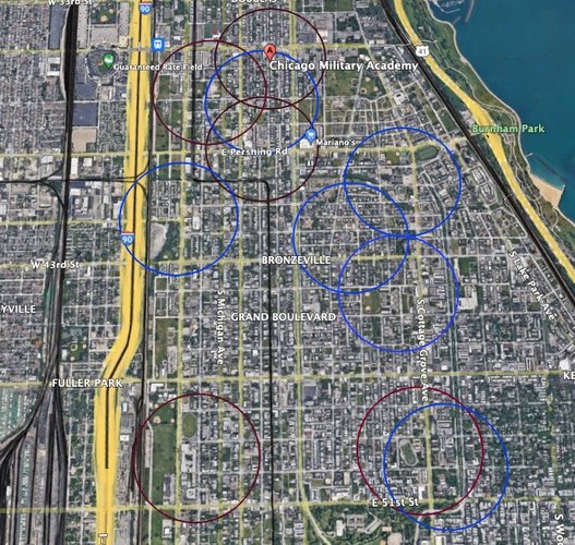
Unfortunately, the extensive number of schools in the neighborhood does not mean that all residents of Bronzeville have walkable schools accessible to them, at least not in the way of the"5-minute neighborhood" outlined by Duany and Steuteville. The map below shows the 5-minute walk shed of each school shown in the map earlier. While there is a lot of healthy overlap between these sheds, there is also some areas of concentration that are too high, such as the three high schools servicing the area from 39th St to Pershing Rd and State St to King Dr. Despite being more evenly distributed, the elementary schools also leave some areas without walkable access to school. The area between 51st to 46th St and S Praire Ave to S Forrestville Ave, in addition to the area between 47th St to 44th St and State St to King Dr, lack access to any school within a 5-minute walk.
Blue circles indicate 5-minute walk sheds from elementary schools. Burgundy circles indicate 5-minute walk sheds from middle/high schools
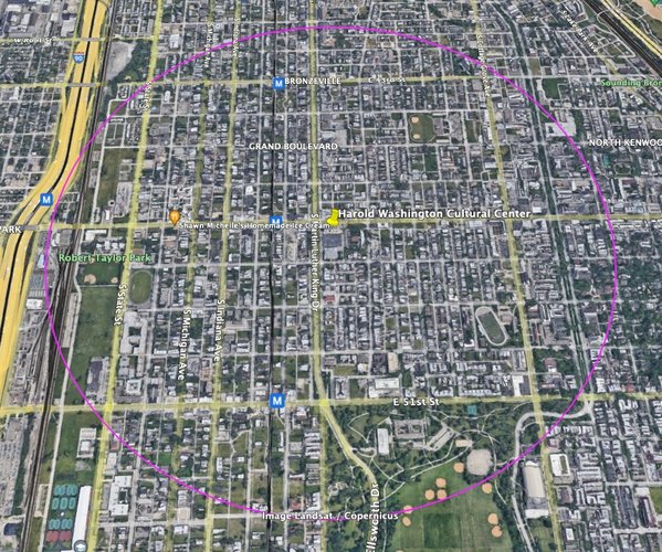
Schools and grocery stores are vital to servicing the neighborhood by ensuring a neighborhood has access to healthy food and reliable education. However, spaces such as community centers are also vitally important for the social and civic life that takes place in a neighborhood. Taking up Harold Washington Cultural Center as this kind of community center, I was interested in how many people have access to it by foot. The Cultural Center hosts a multitude of events including open mics, art shows, and other events open to the public. It is a large center, so it is expected that car traffic will also make up some of the people that attend events there. With this in mind, I determined walkability to mean a 15-minute walk to the center or a radius of 3/4 of a mile. Using Social Explorer, I was able to estimate the population that can access the Harold Washington Cultural Center by foot to be 26,296 people. This is a highly respectable number, and the map below visualizes how this Center can serve nearly the entire neighborhood. While it may not be entirely walkable within the entire 3/4 mile radius, within the neighborhood bounds of this radius, the Center is accessible by foot.
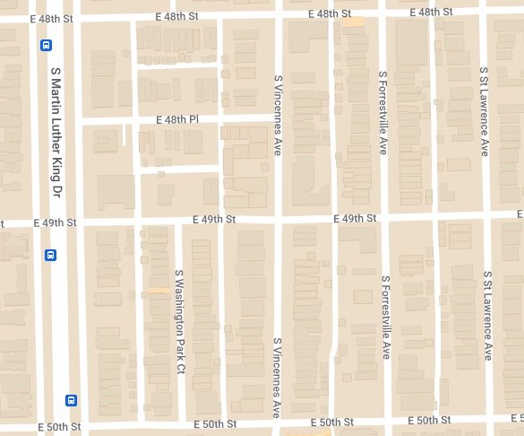
Map of Bronzeville's elongated blocks from S Martin Luther King Drive to S Champlain Ave and 48th St to 50th St
Bronzeville is largely characterized by the elongated block type. These blocks are especially concentrated on the southeast side and northwest side of the neighborhood, which are largely residential areas. According to the Lexicon of New Urbanism, the elongated block establishes uniform lot depth on each block while allowing for a variety of block widths. Pictured Above, we can see a specific area of the southeast corner of Bronzeville which demonstrates the dominance of the elongated block type in the neighborhood. As is shown by the buildings in the map, the lot width can vary, while all lots have the same depth.
The Lexicon of New Urbanism defines a network as “the arrangement of thoroughfares that is the most fundamental structure of the urban fabric” (Plater-Zyberk 2014, 4.1). Bronzeville’s network type most closely resembles the Savannah Pattern, which is composed of elongated and square blocks in a gridiron-type pattern, as pictured below:
Image showing the Savannah Pattern, from"Lexicon of the New Urbanism"
Zooming in on the Bronzeville map, we can see that Bronzeville fits this pattern. In fact, Bronzeville’s network type is almost exclusively a gridiron, with only a few parks and other areas interrupting this gridiron pattern when compared to the Savannah Pattern outlined by the Lexicon. This is shown below:
Bronzeville area between Martin Luther King Drive - Drexel Boulevard, and 43rd St and 47th St showing the Savannah Pattern.
Zoomed-out look at Bronzeville using "Atlas Map" as the base map (on Google Maps)
When we zoom back out and look at the whole of Bronzeville, we can see that the entirety of Bronzeville fits within this gridiron pattern
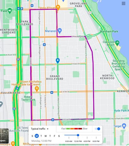
Finally, Bronzeville has a variety of thoroughfare types, which includes various avenues, streets, roads, alleys, and some pedestrian pathways. According to Lexicon of New Urbanism, thoroughfares are defined as “a way for use by vehicular and pedestrian traffic providing access to Lots and Open Spaces. Thoroughfares consist of Vehicular Lanes and Public Frontage” (Plater-Zyberk 2014, 6.1). Within Bronzeville, most of these thoroughfares fall into the aforementioned categories. However, it also contains one important Drive and one important Boulevard. Drexel Boulevard we mentioned at length, Martin Luther King Drive functions as the central thoroughfare of the neighborhood, as can be seen by the map of Bronzeville that includes typical traffic patterns and speeds.
Bronzeville’s overall connectivity is rather impressive given its large size. Like most other Chicago neighborhoods, its connectivity is boosted by the gridiron network or Savannah Pattern structure. Because the gridiron pattern promotes intersections at relatively frequent intervals, different locations within the neighborhood have several pathways between them, whether it be by car or by foot. Unfortunately, due to its size, some distances are unrealistic for pedestrians. However, the number of pathways available to pedestrians means that the neighborhood is connected and available to all those who would like to walk
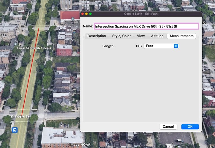
Given that Martin Luther King Drive is both the central thoroughfare in Bronzeville and an arterial street that connects several South Side neighborhoods, I will take it up as an example for examining connectivity. As an arterial street, Martin Luther King Drive has the largest slack when it comes to intersection spacing. According to the Victoria Transport Policy Institute, arterial streets can have up to a maximum of 1,000 feet between each intersection for the neighborhood to be considered “well-connected” (Victoria Transport Policy Institute 2017). Despite being an arterial street, Martin Luther King Drive contains intersections well within that maximum distance, with all intersections on Martin Luther King Drive in the neighborhood bounds being less than 700 feet from each other. The image below shows the distance between the intersections at 50th and 51st St to be less than 700 feet.
Intersection Spacing Between 50th and 51st St on S Martin Luther King Drive
All local streets that I looked at within the neighborhood also fit the guidelines set by the Victoria Transport Policy Institute, with intersections for local streets happening well within the recommended 300-400 foot range. Additionally, there are no cul-de-sacs or gated communities within the Bronzeville neighborhood, promoting open walkways and vehicular travel throughout the entire neighborhood. Unfortunately, not all of the guidelines set forth are met by Bronzeville. When it comes to street pavement widths, almost all street widths were longer than the recommended 24-36 feet. I measured the width of Martin Luther King Drive, the busiest and widest street in the neighborhood, to be a whopping 54.65 feet at its busiest intersection—crossing 47th Street. All of these results lead me to believe that while Bronzeville is a well-connected neighborhood, it could use some slight improvements to promote even more pedestrian travel and slowing down vehicular traffic.
Intervention Diagram: This Map previews the interventions I am proposing. You can view the interventions individually or together in the map
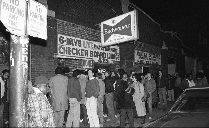
In the first section of my analysis, I discussed Bronzeville’s rich history as a hub of Black life in Chicago. In many ways, Bronzeville’s golden era encapsulated many aspects of an ideal neighborhood: due to the restrictive covenants preventing people from moving out, it had a densely built environment that promoted walkability with nearby services such as schools, local grocery stores, and small businesses. In addition, it was rich with cultural and art institutions such as the Regal Theater, Checkerboard Lounge, and others that helped cultivate a vibrant environment in the neighborhood. The most important reason for Bronzeville’s golden era, however, was the people that inhabited it. Bronzeville was the hub of Black life because it was full of life, and the densely built environment encouraged interaction among its many residents. Unfortunately, the mass migration out of Bronzeville previously discussed has left a lot of vacancies where there were either people living or important businesses. In fact, from 1950 to 2010, Bronzeville lost 75% of its population. As people left Bronzeville, many businesses left with it, and empty space has taken over a lot of what was once either institutions or residential buildings. However, the strong gridiron block pattern and short blocks between street intersections mean reconnecting and rebuilding the density of the neighborhood is within reach.
Checkerboard Lounge, 1983 (Chicago Tribune)
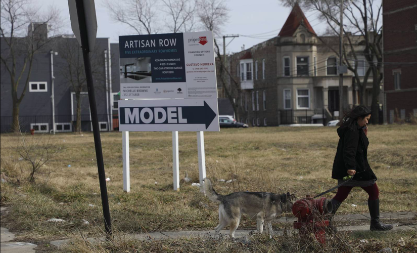
Empty lot where Checkerboard Lounge once stood, 2021 (Chicago Tribune)
Therefore, my proposal, Revitalize Bronzeville, includes three targeted interventions that attempt to rebuild the density in Bronzeville and enhance the structure of the neighborhood to better connect people to the important cultural institutions and commercial corridors. My three interventions are: (1) Slow down vehicles along MLK Drive through the expansion of sidewalks and installation of protected bike lanes (2) Build a 6-story apartment complex on Calumet Ave between 50th and 51st St (pictured below) (3) Revitalize the 51st St commercial corridor by converting it to a mixed-use zone much like the 47th and Cottage corner.
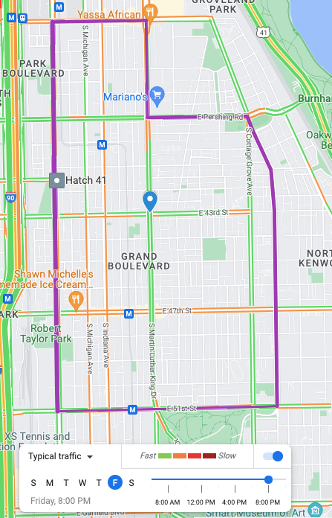
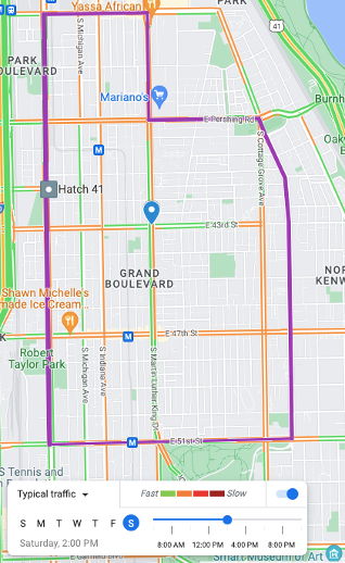
My first intervention targets high-speed vehicular traffic that cuts through the neighborhood. Under intervention one, you will see two maps of vehicle traffic, provided by Google Maps data. As we can see, there are seven different high-speed roadways that cut through Bronzeville, and this does not include the high-speed border streets. The most significant of these, however, is S Martin Luther King Drive, which at both selected times is nearly always at the highest speed indicated by the Google Map. MLK Drive functions as a highway in the middle of the neighborhood, which encourages people to use the neighborhood as a means to get to other neighborhoods, rather than stop in Bronzeville to see what it has to offer. Additionally, it separates the East and West sides of the neighborhood rather than connecting them. With the 95/Dan Ryan Expressway immediately west of the neighborhood, it does not make sense to have such a high speed arterial street go through the middle of the neighborhood. Therefore, I am proposing that MLK Drive be reduced to one lane of vehicle traffic. Protected bike lanes will be installed to replace the outer lanes, and the medians will be pushed in to make room for sidewalks. These will be added on either side of the medians that separate the main road from the residential one-way lanes of MLK Drive. TThis will reduce the speed of vehicle traffic through the neighborhood while also better promoting alternative modes of transportation—namely walking, biking, and transit—between the north and south sides of the neighborhood. These improvements will make bring everything that works about Drexel Boulevard, which is a beautiful boulevard with a walkway, into the middle of the neighborhood rather than on the edge. By reducing this speed, more community members will be encouraged to walk and bike along the thoroughfare that connects three important commercial corridors: 43rd St, 47th St, and the revitalized 51st St corridor. Finally, as MLK Drive converges into Washington Park at the 51st St intersection, it makes sense to encourage people to bike into and out of the park that borders the neighborhood on the south.
My second intervention is aimed at reducing the number of vacant lots that plague the Bronzeville neighborhood. Despite most of these lots simply being green spaces, most of them are not well-maintained, and they serve no real purpose as they are not public parks. Given the housing crisis in Chicago, it is a reality that there are far too many green spaces in Bronzeville where there could be affordable housing for people struggling to find and afford shelter, especially given that these green spaces are not public property. My intervention to build a 6-story apartment complex along Calumet Ave between 50th and 51st St would promote affordable housing while also bringing getting rid of some of this vacancy. The complex would be built on the front of the lot, promoting strong street frontage, and it would be accompanied by a small parking lot in the back, accessible by the alleyway between Calumet and MLK Drive. According to the Chicago Department of Planning and Developing Zoning Map, these plots of land are already designated as an RM-5 zone, meaning it is supposed to be used for a Residential Multi-Unit district. However, these have a height limit of 45 feet, which is only up to 3 or 4-story buildings, while the RM-6 zones do not have a height limit. Given that the RM-5 and RM-6 zones require the same minimum lot area of 1,650 square feet, it would be possible to change this zone for this type of development. In accordance with the city’s Affordable Requirements Ordinance (ARO), 20% of the units in this apartment complex would constitute affordable housing, while the other 80% would be market rate. While rent in the area is not cheap, it is much more affordable than many other median-income neighborhoods in Chicago, attracting young people living by themselves and small families into the units. The location of this complex is important as it is a short walk from the 51st Green Line Station sits, and sits close to 51st St, prompting people to use CTA rather than drive while also encouraging them to support local businesses along 51st St.
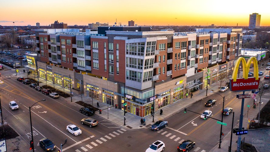
My third intervention also targets vacancy, but it stems from work that is currently being done to revitalize the neighborhood. There has been investment into both 47th St and S Cottage Grove Ave as commercial corridors, with a focus on mixed uses. This is epitomized by the corner of 47th and Cottage Grove, where there is a large mixed-use development (pictured below). I am proposing that a similar investment be made on 51st St from South Praire Avenue to Indiana Ave. This block has a vacant lot, several green vacant plots of land, and a couple of closed businesses. There are many community-led initiatives to help revitalize this area, including the Build Bronzeville initiative which is housed on the Northeast corner of the intersection between 51st and Prairie Ave, and has some restaurants inside and adjacent to the building. However, some of the businesses they helped open had to close under the financial pressures of the pandemic, and there is not enough outside money to sustain these initiatives. Thus, I am proposing a dense, mixed-use development, which would still allow all current open businesses to be housed on the ground floor of the development. Otherwise, they will be provided assistance with relocation. All ground-floor spaces for businesses will be rent-controlled to encourage local small businesses to move in. One important caveat would be a requirement for a local produce or grocery store, located along Calumet Ave, facing the Build Bronzeville building. The nearest full-service grocery store to this area is the Walmart Neighborhood Market, which is quite a long walking distance. By placing a grocery store here one here, people will be encouraged to stop by the other businesses as they go to do groceries. By having people move into these units, we would be attracting a hyper-local customer base people and encourage more business in an area where several businesses are having to close.
These maps show vehicle speed in Bronzeville at times when people would ideally be walking through the commercial corridors in the neighborhood. Unfortunately, we can see that Martin Luther King Drive, (which runs South - North, marked by the blue place marker) is almost always green or orange, indicating high-speed vehicle transit. (Image Credit: Google Maps).
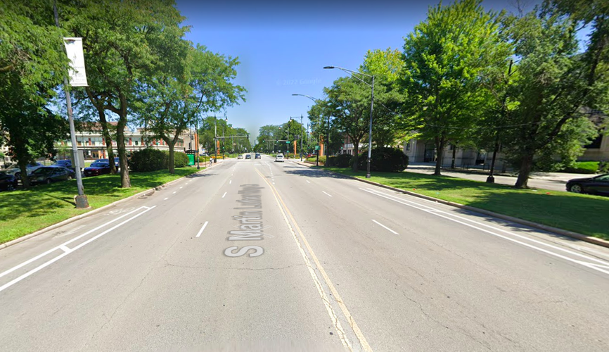
This is an image of S MLK Dr facing north, between 48th and 47th St. As we can see the bike lanes are quite thin and do not promote road safety. My proposal would change that to reduce vehicle speed. The sidewalks would be installed opposite of the green medians so that pedestrian traffic is kept on the lower-speed residential one-ways of MLK Dr. (Image Credit: Google Maps Street View)
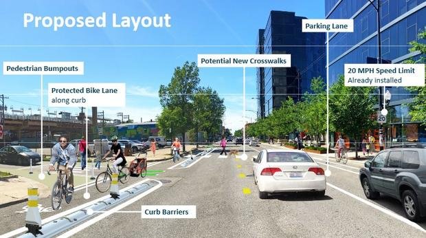
This is a proposal done by CDOT in 2020 for protected bike lanes on Milwaukee Ave in the Logan Square neighborhood. My proposal for MLK Dr is similar, without the parking lane. (Image Credit: CDOT)
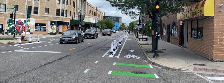
This is what the current installation looks like in Logan Square. Traffic speed has been reduced as a result of these being installed. (Image Credit: CDOT)
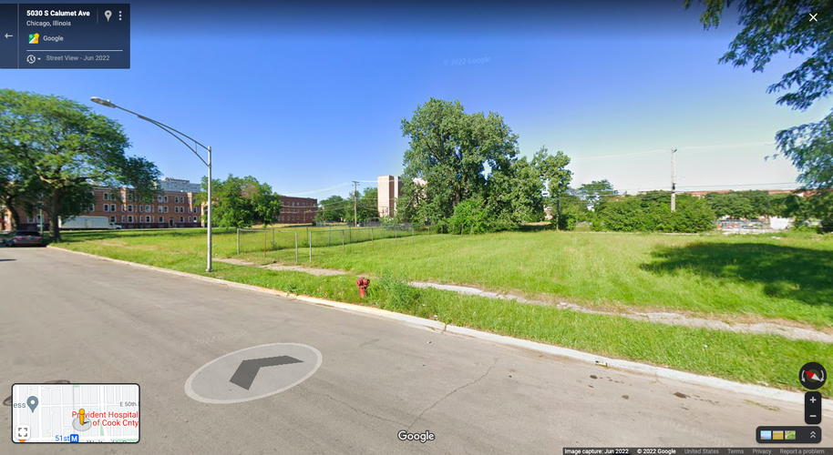
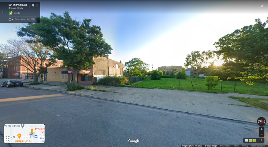
This is the empty lot along Calumet Ave where Intervention #2 would be developed. As we can see, this a huge empty space that does not serve a purpose to the neighborhood residents as it is not a designated public space. (Image Credit: Google Maps Street View)
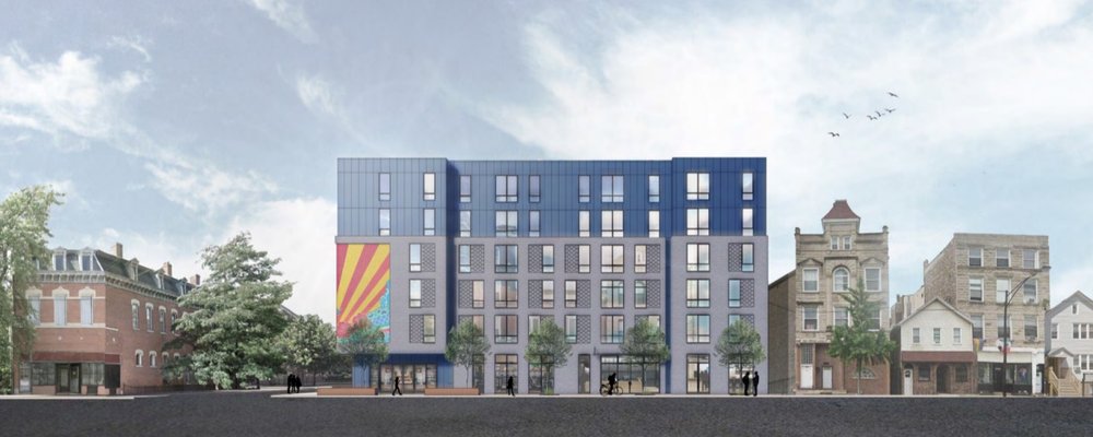
Rendering of a 6-story affordable apartment complex proposed in 2019 for Pilsen. The structure I am proposing would be quite similar, with some design tweaks. Murals would be painted by local artists, and the building generally would attempt to fit into the color pallette of the neighborhood. It will importantly be built to the sidewalk line, promoting strong corners and providing important street frontage. (Image Credit: Block Club Chicago, Resurrection Project)
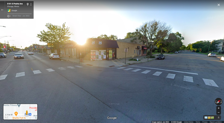
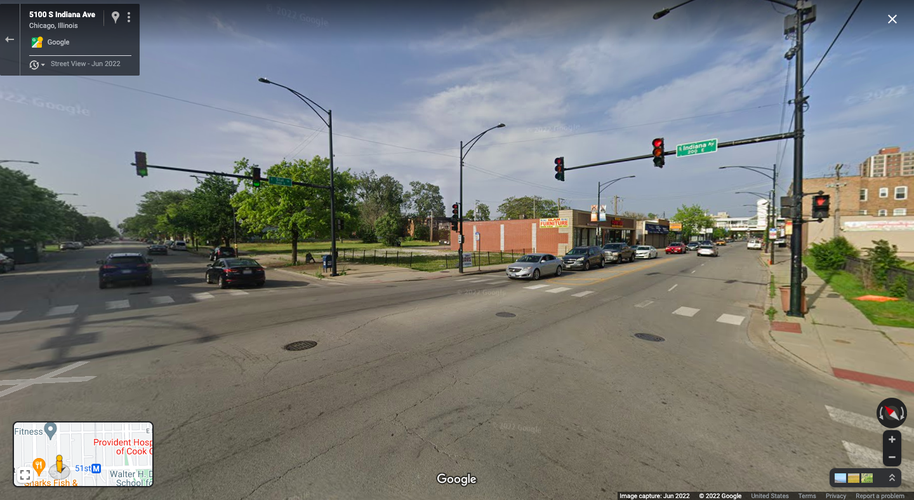
This would be the site of the proposed mixed-use development. It would stretch from 51st and Prairie (the top picture) to 51st and Indiana (the bottom picture). As we can see, the areas immediately behind the businesses have a lot of empty space, and the buildings themselves do not provide strong street frontage due to their low-rise nature. (Image Credit: Google Maps Street View)
This is the inspiration behind the proposed development, located on the corner of 47th St and Cottage Grove Ave. The design of the development on 51st does not need to be identical or even all that similar, but it is important for the ground floor business spaces to have windows like the ones pictured here to provide a natural sense eyes on the street in this area. (Image Credit: Colliers)
This is where the local grocery store would be located on Prairie Ave. It is slightly removed from the immediate traffic of 51st St, but adjoins the rest of the development to provide a final destination for people to arrive to.
Social Mix
Using data from Social Explorer and the Simpson Diversity Index, Bronzeville does not appear to be a very diverse neighborhood, whether tested on its own or compared to the greater City of Chicago. The indices I chose to measure diversity were race, educational attainment, and housing tenure. Using the City of Chicago as a baseline, we can see that the City itself does very well across these indices. I used 5 categories for race (Non-Hispanic/Latino Black, Non-Hispanic/Latino White, Asian, Hispanic/Latino, and Other) and educational attainment (less than high school, high school diploma, some college, Bachelor's degree, Master's/Professional/Doctorate Degree. Therefore, the ideal number to have perfect diversity is 5 for each of these variables. As we can see on the table, the City of Chicago has very high educational attainment diversity, with an index of 4.83. It is not as good when it comes to racial diversity but still does fairly well with an index of 3.56. The last variable, housing tenure, only has two inputs (renter-occupied and owner-occupied), with a value of 2 indicating perfect diversity along this variable. In this category, the City of Chicago has a near-perfect diversity index of 1.98, meaning nearly half of occupied housing units are renter-occupied and half are owner-occupied.
When compared to the City of Chicago, Bronzeville, Grand Boulevard Community Area, and the Grand Boulevard Chicago Region have much less diversity across the board. Because the Grand Boulevard Community Area and the Grand Boulevard Chicago Regions have almost identical boundaries, their scores are quite similar. Bronzeville is slightly more diverse than Grand Boulevard when it comes to housing tenure, as its score of 1.63 is much higher than Grand Boulevard's score of 1.24 for housing tenure. While Grand Boulevard is almost all renter-occupied, Bronzeville has a healthier, albeit less than ideal mix of housing tenure (it is still over 70% renter-occupied). Both Bronzeville and Grand Boulevard have a reasonably high index of educational attainment, meaning that there is some diversity with respect to this variable in both Bronzeville and the greater Grand Boulevard area. Finally, the Grand Boulevard area is actually more racially diverse than Bronzeville. As we can see in the tables above, Grand Boulevard's has an index of 1.6 for the variable of race, while Bronzeville has an index of 1.28. This is reflected in the overall Demographic table of Bronzeville, where 88.2% of the population is Non-Hispanic/Latino Black. Thus, despite having decent educational attainment diversity, Bronzeville's racial and housing tenure diversity demonstrate that the neighborhood falls short of being a truly "diverse" neighborhood.