Overview
Social Mix
Public Space
Amenities
Connections
Final Project
Size
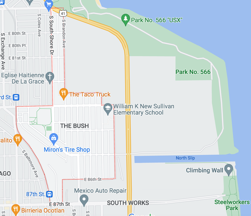
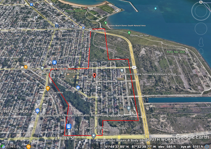
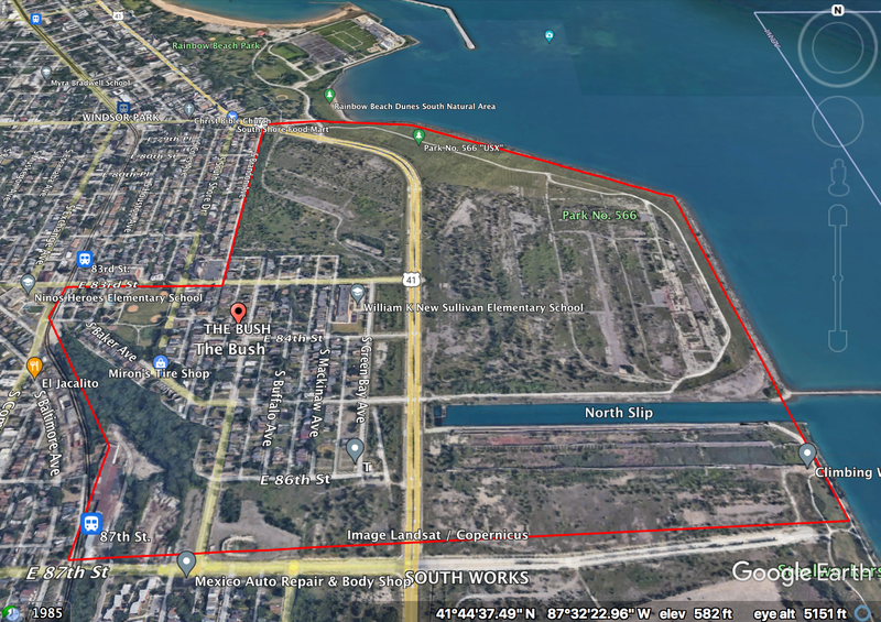
The total population of the Bush is about 2,500. If one excludes the parks that are adjacent to the Bush, which is done in many maps of the Bush on the internet, the neighborhood has an estimated perimeter of 2.94 miles and an estimated area of 179.16 acres. If one includes the parks, the Bush’s estimated perimeter increases to 3.8 miles and its estimated area increases to 510 acres.
Source for population: https://www.socialexplorer.com/73a2f5df75/explore?openold=true
Identity
One aspect of the Bush that provides it a sense of coherence is its street art, which mostly revolves around love, rebuilding, and hope for the future. When juxtaposed with the many destroyed and uninhabitable homes in the neighborhood, this art conveys that the Bush’s residents have pride in where they live but also want more investment into the neighborhood’s future.
There is a strong Catholic presence in the neighborhood due to St. Michael the Archangel Catholic Church, which towers over all other buildings.
Another aspect of the Bush’s identity are the remnants of its industrial past. On my walk through the neighborhood, I saw abandoned iron and tire shops, a lot where affordable welding takes place, junk yards, and large wooded areas and grasslands that were closed off by the United States Steel Corporation. East of the homes of the Bush is the Steelworkers park, which is what remains of the South Works steel manufacturing plant.
The consistent styles of homes in the Bush also add to its identity. Along South Shore Drive and Brandon Avenue, from 80th to 83rd, the homes are mostly bungalows and two-story apartment buildings. Throughout the rest of the neighborhood, the style of homes is the frame two-flat, which are older homes that once served as a bridge for the working class between apartment life and bungalows.
Source: https://chicago.curbed.com/2015/9/3/9924658/also-home-prints
The final aspect of the Bush’s identity that I noticed during my walk was the race of its residents. The residents of the neighborhood are mostly Black and Latin, which is typical of South Chicago as a whole. Some homes had Mexican flags on their porches and others had Black Lives Matter flags in their windows.
Layers
The Bush, without considering its neighboring parks, has a Texas shape. I firstly added the layer of Cook County Census Tracts, which are red lines that intersect with the Texas shape of the neighborhood and extend out of it. The Census Tracts in the Bush are 4601 and 4602. I added another layer, which was Chicago’s alderman wards. The Blue colored ward is ward 7 and the yellow colored ward is ward 10.
Diagram
History
One can begin their exploration into the history of the Bush by looking at early settlement around Chicago’s rivers. In 1833, Jefferson Davis, who is famously known as the past president of the Confederate States of America, was assigned by the government to conduct a survey for a ship canal that would connect Lake Michigan to the Mississippi River. Davis, who was a captain of the U.S. Army Corps of Engineers at the time, argued that the piers should be built at the mouth of the Calumet River (Hmurovic). To his dismay, the canal was not built at that location. Instead the Calumet Harbor was constructed, and it became a major shipping port (Washington High School).
After the construction of the Calumet Harbor, speculators began to buy land around the Calumet River. They expected this land to become very valuable because it would bridge the divide between railroad and river shipping routes. The town that this land was on was called Ainsworth, and it was mostly settled by Irish Catholics. The four communities of Ainsworth were the Bush, Millgate Cheltenham, South Chicago, and Calumet (Encyclopedia of Chicago).
In 1861, the Illinois General Assembly created the Hyde Park Township. Ainsworth was annexed into that township, and it also started to become more commonly referred to as South Chicago at that point (Encyclopedia of Chicago).
The 1860s and 1870s were pivotal moments for the development of industry in the Bush and in South Chicago in general (Sellers). In 1869, James Bowen and other investors founded the Calumet and Chicago Canal and Dock Company. Bowen and the other investors purchased land in the Calumet region in the 1870s. Their company also lobbied Congress for legislation and they were provided with funds to deepen the river and improve facilities. The enhancement of the Calumet Harbor by Bowen’s company and other companies led to the development of more industries as well as attraction of workers to the Bush and to South Chicago in general, especially after the home destruction from the Chicago Fire of 1871 (Southeast Chicago Archive).
In the 1880s, the North Chicago Rolling Mill, later known as South Works, moved to the Southeast side. Advantages that the Southeast side provided for the steel mill included shipping routes for iron ore, coke, and limestone. There were also many skilled workers who moved to the area due to previously stated reasons. South Works quickly became a major source of employment for the residents of the Bush and it continued to be well into the 20th century (Sperling).
The Hyde Park Township, of which South Chicago/Ainsworth was a part, was annexed into Chicago in 1889. At that time, the steel industry was booming on the Southeast side. This resulted in U.S. Steel acquiring South Works in 1901 and expanding its facility to 79th street. African American workers, in particular, worked as stevedores, which are people who load and unload cargo from ships. Their families were pushed to live in neighborhoods near the Chicago River, such as the Bush, which had the worst quality housing. And as South Works’ business continued to develop and cause environmental conditions in surrounding neighborhoods to severely worsen, the Bush’s initial residents, the Irish, moved out to better neighborhoods on the East Side (Encyclopedia of Chicago).
During World War I, Mexican immigrants began to be employed at U.S. Steel. These immigrants were specifically hired as strikebreakers during the 1919 U.S. Steel Strike. Their families were also pushed into living in the Bush due to segregationist pressures from white residents. The ethnic divisions in the Bush and in South Chicago were clearly present and strong, but they were generally bridged starting in the 1930s by Catholic religion, Democratic party involvement, and worker unionization (Encyclopedia of Chicago).
For decades, South Works was a pillar of the Bush’s and South Chicago’s economic functioning. By the 1960s, over 20,000 people from these and other neighborhoods were employed there. But when South Works began to decline in the 1980s, the economy of the Bush and South Chicago declined as well. And by the 1990s, when South Works was completely shut down, the economies of these Southeast side neighborhoods were destroyed (Encyclopedia of Chicago).
While taking a walk through the Bush, one can clearly see the lasting effects of South Works’ shut down. There are few local businesses and many houses sit in an uninhabitable state. Residents of the Bush and of South Chicago live amidst this lasting collapse everyday, and they have pushed the city to provide resources for redevelopment. Throughout the 2000s and 2010s, community groups from these areas have submitted redevelopment plans (United Way of Metro Chicago). The city has also approved for LEED neighborhood developments for the South Chicago neighborhood multiple times within the last 15 years (Olson).
Sources:
Bensman, D. (n.d.). South Chicago. Encyclopedia of Chicago. Retrieved October 15, 2022, from http://www.encyclopedia.chicagohistory.org/pages/1170.html
Bowen High School. Southeast Chicago Archive & Storytelling Project. (2021, April 30). Retrieved October 15, 2022, from https://www.sechicagohistory.org/archive/browse/bowen-high-school/
Hmurovic, J. (2018, June). What do Jefferson Davis, Winston Churchill's father, president Grover Cleveland, Jack Johnson and Wyatt Earp have in common? Whiting-Robertsdale Historical Society. Retrieved October 15, 2022, from https://www.wrhistoricalsociety.com/jefferson-davis
Olson, W. (2009, May 13). South Chicago Leed Neighborhood Development. Green Bean Chicago RSS. Retrieved October 15, 2022, from https://web.archive.org/web/20090720005350/http://www.greenbeanchicago.com/south-chicago-leed-neighborhood-development-green-chicago/
Sellers, R. (2006, March). Chicago's Southeast Side Industrial History. Chicago State University. Retrieved from https://www.csu.edu/cerc/researchreports/documents/ChicagoSESideIndustrialHistory.pdf
South Chicago - United Way of Metro Chicago Neighborhood Network. United Way of Metro Chicago. (2020, December 4). Retrieved October 15, 2022, from https://liveunitedchicago.org/neighborhood-networks/south-chicago/
Sperling, D. (2011, April 9). South Chicago Industry- US Steel South Works. Northeastern Illinois University. Retrieved October 15, 2022, from https://web.archive.org/web/20110409183720/http://www.neiu.edu/~reseller/scussteel.html
The center of my neighborhood
The center of The Bush is Russell Square Park. The streets that border it are 83rd Street to the North, South Shore Drive and Bond Avenue to the East, Baker Avenue to the South, and Houston Avenue to the West. The park itself consists of a playground, a pool, basketball courts, baseball fields, tennis courts, a very large field that has a walking trail going through it, and a field house that has a basketball gym and fitness center inside of it. Across the street from the park’s field house is the school EPIC Academy, which is a public charter high school. One block east of the park is St. Michael the Archangel Catholic Church. There is also significant public transportation around the park. On 83rd street and on South Shore drive, there are bus stops for the 5, 26, 71, and 95 buses. One block west of Houston Avenue, which is Commercial Avenue, there is the 83rd Metra train stop. As can be seen from visiting The Bush, the high school, the church, and the public transportation stops draw a lot of traffic to and around the park.
At its inception in the early 1900s, Russell Square Park provided social services and community spaces to underserved residents of The Bush. Some of these services included year-round recreational and social activities, English lessons and other educational programs, hot meals, and public bathing facilities (Chicago Park District). Now, in the 2020s, the park still offers programs and social services to the residents of The Bush. There are always after school programs at the park for children and teens in the neighborhood during the school year. There are also always summer programs at the park for children and teens when they are not in school. In each of these programs, there are sports teams available for youth to join. The park also offers a teen club for 15-17 year olds as well as a senior citizens club for 60+ year olds. In addition to these clubs and programs, the park hosts seasonal events such as movies in the park, a Turkey Trot running event, a Park Showcase, and many others (Chicago Park District).
To evaluate whether or not the park truly draws people from The Bush together, I used Vikas Mehta’s five dimensions of public space as a frame. The first of these dimensions is inclusiveness. Age-wise, the park is successful in how it draws in school aged populations, but there is noticeably less for child-less young adults and adults to do at the park besides playing basketball and exercising at the fitness center. Sports and exercise are significant conduits of adult social interaction though. And the park is definitely lively in the summer and more frequented by adults because the outside basketball courts are usually open then and the weather is usually conducive to family and friend gatherings in the park’s field. However, in the winter time, when it is less feasible to gather outside, I do wonder where adults who live in The Bush go to congregate outside of their homes. Mehta’s second dimension is meaningful activities. As mentioned previously, residents of The Bush have the opportunity to go to after school programs, social clubs, sports programs, and seasonal events at the park. These activities cover a diverse range of interests and they are all meaningful. Perhaps, to address my first point, there could be more activities for adults at the park though. Mehta’s third dimension is comfort. When I visited the park on a Wednesday afternoon in October, I was the only one there. Few cars drove by me as I walked along the streets that border the park, and I did not see any other pedestrians until I walked closer to Commercial Avenue. This occurrence can easily be explained by the fact that most residents were likely at work or school at the time I took my walk. But, as a prior resident of The Bush’s neighboring neighborhood, South Chicago, there have been times at which I have visited Russell Square Park outside of business and school hours and have still been one of very few people there. These occurrences have made me feel less comfortable in the park. And since the park is so large, I felt unsettled by the possibility that someone was unseen and watching me walk around. I have definitely felt more comfortable in the park when I have gone with other people and when there are many people there. I also imagine that residents of The Bush feel similarly about comfort in the park. Mehta’s fourth dimension is safety. As implied from what I just said about comfort, it can also feel and be unsafe to go to the park alone or when it has very few people in it. There have been shootings and stabbings at the park that have occurred not only during the night time, so park visitors always have to be vigilant when visiting the park by themselves or with others. Mehta’s final dimension is pleasurability. The park’s green space is enclosed by the housing and other buildings, such as the high school and church, that surround it. The paths that go through the park are paved for walkers and runners. There are benches available for visitors of the park to sit. The grass in the field appeared to be regularly cut and maintained. There was very little trash on the ground when I walked through the park too. This all gave the park a serene feeling that would have been completely pleasurable if not for the discomfort I felt while being alone. From my past experiences when I have visited the park with others on warm days in the summer, the park felt significantly more pleasurable.
Overall, I feel that the park does well at drawing residents of The Bush in during the summer time. There are things for people of all ages to do, and there’s enough space in the park for many people to congregate at once. Some factors that may push people away from the park are safety concerns and discomfort when visiting the park when it is relatively empty. During the colder seasons when people shift mostly inside for social interaction, the draw of the park’s outside features definitely decreases. But the park still seems significant to the neighborhood during this time because there are after school programs, sports teams, and social clubs for residents to join as well as an open basketball gym, a fitness center, and holiday themed events for them to frequent or attend.
Sources:
1. Russell (Martin) Square Park. Chicago Park District. (2022). Retrieved October 31, 2022, from https://www.chicagoparkdistrict.com/parks-facilities/russell-martin-square-park
2. Vikas Mehta. (2014). Evaluating Public Space, Journal of Urban Design, 19:1, 53-88, DOI: 10.1080/13574809.2013.854698
For my next analysis of The Bush, I will reflect on the ways in which it provides and does not provide walking access to daily life needs and other amenities. The daily life needs and amenities will be separated into categories, which are grocery stores, convenience stores, schools, restaurants, shops/local businesses, public transportation, churches/other religious buildings, libraries and community centers, recreation and exercise space, emergency services, and pedestrian friendly streets.
The Bush does not have its own grocery store, but there is one that is about a five minute walk from The Bush, on 83rd and Escanaba, which is west of the train tracks and busy intersection on Commercial Avenue. This grocery store is Save a Lot, and it sells produce and meat. As a prior resident of the South Chicago neighborhood, which is adjacent to The Bush and is the neighborhood this Save a Lot is in, I have shopped at this Save a Lot with my mom many times before. It usually has low stock and limited choices. The quality of food is also mostly decent, but sometimes the produce and meat can be questionable in their freshness and shelf lives. The next closest smaller grocery stores to the neighborhood, which are more resemblant of Mexican markets, are between 88th-91st street and Commercial Avenue in South Chicago. They are not accessible via a five minute walk from The Bush unless a resident lives at the southernmost part of the neighborhood. The closest large grocery stores to the neighborhood are Jewel Osco on 75th and Stony Island in the Grand Crossing neighborhood, Local Market Foods on 71st and Jeffery in the South Shore neighborhood, and Jewel Osco on 95th and Stony Island in the Pill Hill/Jeffrey Manor neighborhood. All of these stores are inaccessible via a five minute walk from the Bush. One would have to drive or take public transportation from the neighborhood if they wanted to get to these stores reasonably quickly.
Picture taken by Sharon Williams
The Bush does not have convenience stores within its boundaries. However, there are a couple just outside the boundaries that draw in residents. One of these stores is the South Shore Food Mart, which is on 79th and South Shore Drive. Its food options are similar to those at Walgreens and CVS and it is accessible via a five minute walk down South Shore Drive to residents of the Bush who live north of 83rd street. There is also a convenience store that is a part of a gas station, on 83rd and Exchange, that has similar food options to the food mart. To access other convenience stores, residents have to go to Commercial Avenue, between 88th to 93rd street. These stores take more than five minutes to walk to, but there is a CTA bus that residents can take down Commercial to get to them. On the other hand, it would be ironically inconvenient for residents to wait for and take the bus to convenience stores.
Picture taken by South Shore Food Mart
The Bush has one school that is within its neighborhood boundaries, one school that sits adjacent to its boundaries, and one school that is a few blocks west of its boundaries. William K New Sullivan Elementary School is in the Bush on 83rd and Mackinaw Avenue. There are speed bumps, pedestrian crossing signs, stop signs, and school zone speed limits that make the street safer for pedestrians walking to the school. Epic Academy, which I’ve mentioned in a previous neighborhood analysis, is adjacent to the neighborhood’s boundary, across the street from Russell Square Park, and on 83rd and Houston Avenue. Epic Academy also has pedestrian crossing signs, stop signs, and school zone speed limits to provide for safe streets for walking pedestrians. Ninos Heroes Elementary School is west of 83rd and Commercial Avenue and less accessible for pedestrians walking from the Bush because they have to cross train tracks and a busy intersection to get to the school.
Train tracks and intersection that stand between The Bush and Ninos Heroes Elementary School
The only restaurant in the Bush is a food truck called The Taco Truck. I’m conflicted about counting this as a restaurant since it is not fixed in place. There are a few restaurant options one block west of The Bush, on 83rd and Exchange Avenue. There are also close to no healthy restaurant options within a five minute walk of The Bush. The healthiest options are Mexican restaurants that are along Exchange and Commercial, between 83rd to 85th Street. There is also an African food restaurant, called Southside African Restaurant, three blocks west of The Bush that has healthy options. Because there is not much to choose from in walking distance from the Bush, I assume residents either drive to get food or order it online through delivery services.
Picture from Google Maps
The only local businesses in the neighborhood are a tire shop and a welding business. There are auto repair shops on Commercial between 83rd and 85th street, which is just outside the neighborhood boundaries. Residents have to go far south down Commercial Avenue to access more general shops and businesses.
The Bush has decent public transportation options around its west boundaries, but no public transportation within it or along its east boundaries. There are Metra stops on 87th and 83rd street. There are also CTA bus stops for the 5, 26, 71, and 95 buses along South Shore Drive and 83rd street.
Residents have multiple options of church in and around The Bush, if they choose to attend. The most prominent option is St Michael the Archangel Roman Catholic Church on 83rd and South Shore Drive. There is also Chapel of Resurrection on 84th and Burley Avenue, near William K New Sullivan Elementary. Just outside the neighborhood are Grace Apostolic Church on 83rd and Exchange and Eglise Haitienne De La Grace Baptist Church on 82nd and South Shore Drive.
Chapel of Resurrection
As previously exclaimed, Russell Square Park and its field-house are The Bush’s community center. There are no stand alone libraries in The Bush, but there is one a few blocks south of the neighborhood at 90th and Houston and one seven blocks north of the neighborhood at 73rd and Exchange. These can be walked to, but it would take longer than five minutes to walk to them from The Bush. Also, I would presume that there are libraries inside the schools in and directly outside The Bush, but I am not completely sure.
Russell Square Park is also The Bush’s main recreation and exercise space. There are indoor and outdoor basketball courts, outdoor tennis courts, baseball fields, walking paths, a swimming pool, a fitness center, and a playground for residents to gather and exercise at. The Steelworkers Park, which is directly east of the neighborhood and on the lakefront, also has a rock climbing wall and walking paths that residents can gather and exercise at.
There are no emergency medical services in The Bush outside of nurses offices that may be in the neighborhood’s schools. The closest hospitals are South Shore Hospital on 80th and Crandon, which is in South Chicago, and Jackson Park Hospital on 75th and Stony Island, which is in South Shore. The nearest doctor’s offices are around 91st and Commercial Avenue. All of these places are inaccessible via a five minute walk from The Bush.
Finally, The Bush’s streets are not the most pedestrian friendly. Around highly frequented areas, such as near Epic Academy, William K New Sullivan Elementary School, and Russell Square Park, there are stop signs, pedestrian walking signs, speed bumps, and/or school zone speed limits. These features make these parts of the neighborhood more pedestrian friendly. However, in most other parts of the neighborhood, the streets are wide, stop signs are present but frequently disobeyed, train tracks are present, and traffic lights are not present. The sidewalks are also not well maintained. Trees and bushes often extend onto them, which requires residents to walk on streets. The sidewalks are also not well paved, unless they are the sidewalks near the schools of the neighborhood or those near St Michael the Archangel Roman Catholic Church.
As can be drawn from these brief explorations of the presence of daily necessities and amenities in The Bush, the neighborhood is definitely lacking in mixed use development. Most of the neighborhood is residential, which appears to make it necessary for residents to constantly travel to adjacent neighborhoods such as South Chicago for their needs.
Map of The Bush, including the land to the east of the residential space in the neighborhood:
1. Block Types
The blocks in The Bush are elongated and all of them have alleys between them. The largest group of blocks has boundaries at 86th street to the south, Green Bay Avenue to the east, 83rd street to the north, and Burley Avenue to the west. There is a narrow block group that is shaped like a rectangle that has boundaries at 82nd street to the south, Brandon Avenue to the east, 79th street to the north, and South Shore Drive to the west. There is another block group sandwiched between these two block groups. Most other residential space in the neighborhood has its block space shaped by the path of the Metra train tracks. In each of these block groups, there is free and highly available parking.
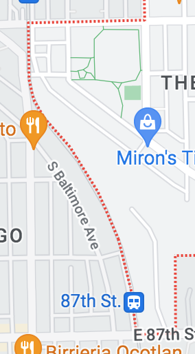
There are irregular blocks in The Bush due to train tracks on the west side of the neighborhood. On the image below, these blocks are right of the red dotted line.
2. Network Types
The Bush is mostly structured according to the Savannah Network Pattern. The blocks are relatively straight, besides some in the western part of the neighborhood that are irregular. Lot depth in the neighborhood is adjusted according to the train tracks and the presence of Russell Square Park and William K New Sullivan Elementary School. There are also alleys between the blocks. All of this disperses traffic throughout the area well, though there usually aren’t many cars on the roads in the neighborhood outside of drop off or pick up time at William K New Sullivan Elementary School or Hope Academy.
There are also hints of the Nantucket Network Pattern in the Bush. The network of blocks near the Metra train tracks at Commercial Avenue follow the traces the tracks make on the landscape. Additionally, Lake Shore Drive and the lots east of it, which are on the eastern side of the Bush, absorb environmental interruptions, namely Lake Michigan, with its shape. Around both of these areas, there is a variety of blocks and lots. The blocks and lots closer to the lakefront are not habited though, which is due to the fact that nothing has been built to replace the South Works Steel Mill that was previously on or near that land.
3. Thoroughfare Types
As previously stated, Lake Shore Drive/Highway 41 is located on the eastern side of The Bush. It is a four lane highway that runs North-South along the lakefront.
South Shore Drive is the only drive besides Lake Shore Drive that is located in The Bush. In South Shore, which is north of the Bush, South Shore Drive runs adjacent to the lake. But at 79th street, the northern boundary of the Bush, South Shore Drive diverts from the lakefront and begins to run North-South like the avenues around it.
South Shore Drive in The Bush
Almost all of the roads that run north-south in The Bush, besides alleys and South Shore Drive, are avenues. The avenues in the picture below are colored yellow. South Shore Drive is colored red. These avenues have high vehicular capacity but also relatively high population density due to the fact that there is a mix of single family and multi-family housing on them. Almost all of the roads that run east-west in The Bush, besides alleys, are streets. These streets are numbered from 79th to 87th. Besides 83rd and 87th street, these streets have lower vehicular capacity than the avenues in the neighborhood. They are also more narrow than the avenues, which makes it necessary for drivers to drive more slowly on them than they would on avenues. There is also an 83rd place that is east and west of Russell Square Park that connects irregularly shaped blocks to Commercial Avenue, South Shore Drive, and Brandon Avenue.
The alleys between the avenues in the Bush are reasonably narrow. They can just barely fit two cars on them.
The only paths in The Bush are in its parks. There is a path that runs through the Steelworkers Park, which is east of the residential space on the Bush and on the lakefront. There is also a path that runs through and around Russell Square Park.
Overall, The Bush is well connected with respect to block, network, and thoroughfare type and pattern. The only thing that separates residential space in the neighborhood is Russell Square Park. But, as written previously, this park is the center of the neighborhood. So it is less of a separator than a heart. Because the blocks are arranged pretty consistently in a grid-like pattern, the neighborhood is easy to navigate. With respect to networks in the neighborhood, the organization of the blocks also allows for dispersal of traffic. There is occasionally congestion near the schools in the neighborhood and the train tracks just west of the neighborhood, but the quite wide avenues throughout the neighborhood do well at pushing traffic away from busy intersections. The presence of Lake Shore Drive at the edge of the residential space in the neighborhood, and near William K New Sullivan Elementary, also does well at dispersing traffic. Many cars that go in and out of the neighborhood are traveling to and from Lake Shore Drive.
Though the neighborhood is structurally well connected, I have still found that social interaction by residents is limited by the neighborhood’s lack of necessities and amenities. It is almost always necessary for residents to drive to access what they need, besides school and church if they attend either. But because the blocks and networks are arranged to allow for smooth, quick transportation, driving around the neighborhood is no trouble. I would imagine that if there was more investment in necessities and amenities on the avenues and streets in the neighborhood, the social interaction between residents as they are walking in the neighborhood would occur easily and frequently.
Sources:
Google Maps
Google Earth
The Lexicon of New Urbanism
For eighty years, the South Works steel mill was the economic backbone of The Bush. When it closed in the 1990s, the economy and infrastructure of The Bush were destroyed. Now, about thirty years after the mill’s shutdown, the neighborhood still lacks services for its residents. For my project’s interventions, I began to respond to and remedy this lack of servicing and meet residents’ daily life needs. 83rd street will be the site of my interventions because it is currently the most active street in the neighborhood and it has lots of space for development and redevelopment. Additionally, The Bush has already decent social diversity, it has lots of available public space for residents at Russell Square Park, and it is well connected. The deficient servicing thus appeared to me to be the most necessary to initially address.
This is a map of my interventions. The background is a screenshot from Google Maps. The interventions are highlighted in orange and placed in their exact location on 83rd street.
First, I envision the construction of a smaller-sized grocery store on a currently empty lot on 83rd and Burley Avenue. South Chicago, of which The Bush is a part, is a food desert. Many residents of The Bush are thus food insecure. The closest grocery store to the neighborhood is a Save a Lot on 83rd and Escanaba, which is a 7 minute walk from the center of the neighborhood (83rd and South Shore Drive). This grocery store, which currently serves the tens of thousands of residents in South Chicago, is quite small and it often suffers from issues of low inventory and low food quality. The construction of a new grocery store in The Bush would take some load off of the Save a Lot, increase residents of The Bush’s access to healthy and fresh food, and mitigate food insecurity that residents face.
Screenshot from Google Earth of what 83rd and Burley currently looks like.
Visualization of the grocery store placement. Stock illustration from https://www.dreamstime.com/supermarket-store-city-place-district-mini-market-shopping-cart-trolley-standing-grocery-flat-vector-illustration-isolated-image207355610.
Second, I will continue to meet residents’ daily needs by channeling the spirit of Jane Jacobs. I plan to redevelop mixed-use space in three buildings on 83rd street. All of these buildings will have residential space on top and commercial space on the ground level. Additional effects of these redevelopments include un-deadening 83rd street, increasing foot traffic, and creating more opportunities for resident interactions.
The first mixed-use space, on 83rd and South Shore Drive, would be a convenience store, which the neighborhood currently lacks. Residents shouldn’t have to walk ten or more minutes, take public transportation, or drive to access a convenience store.
Screenshot from Google Earth of the mixed-use building where the convenience store would be located. The location is 83rd and South Shore Drive.
The second mixed-use space, on 83rd and Brandon Avenue, would be an art gallery and business where the street artists and other artists of the neighborhood could exhibit and sell their art. This space would have another effect of nurturing the neighborhood’s culture and sense of community.
Screenshot from Google Earth of the mixed-use building where the art gallery would be. The location is 83rd and Brandon Avenue.
Pictures I took of street art around the neighborhood.
The final mixed-use space, on 83rd and Commercial Avenue, would be a health clinic/emergency medical services, which the neighborhood also currently lacks.
Screenshot from Google Earth of the mixed-use building where the health clinic/emergency medical services would be. The location is 83rd and Commercial Avenue.
Residents may not be able to or may not desire to cook for themselves and their families every day. They still will have to eat, so buying food at a restaurant would be necessary. In consequence, my third intervention will be the construction of a big restaurant in a building that’s currently for sale/lease on 83rd and Brandon Avenue. The only restaurants that are currently in the neighborhood are a taco food truck and a walk-up donut shop, if these even count as restaurants. In nearby neighborhoods/community areas such as South Chicago and South Shore, healthy restaurant options are also limited. There is also notable cultural diversity in the neighborhood: The Bush’s residents are mostly Black/African American and Hispanic/Latino. Taking this all into account, I envision that the restaurant’s menu would have healthy food options from the cultures of both of these groups. The restaurant would be the first sit-down eating space in the neighborhood, attract diverse resident groups, be a conduit for the cultivation of community, and increase access to healthy pre-made food.
Screenshot from Google Earth of the space that’s for sale/lease where the restaurant would be. The location is 83rd and Brandon Avenue.
The picture on the left is of African American cultural food, also known as soul food. It was found at https://www.pinterest.com/pin/700943129485300700/. The picture on the right is of Mexican cultural food. It was found at https://www.chefspencil.com/most-popular-mexican-foods/.
These interventions would activate 83rd street, address the current shortcomings within the neighborhood’s servicing, and encourage residents to walk around their neighborhood and interact with their neighbors. They should also only be a starting effort. The rest of the neighborhood deserves similar developments and redevelopments as well. 83rd street should not be the only street in the neighborhood that is ever activated.
Social Mix
The following basic demographic tables depict The Bush’s diversity through multiple categories. The Bush is unevenly split into two census tracts, and some of resident data of the adjacent neighborhood, South Chicago, is included in each of the tracts. I could not split up The Bush from South Chicago in a more precise way on Social Explorer, so the data below is not the most representative of my neighborhood. However, all residents of The Bush are encapsulated in the data. So one can still gain a well-defined sense of the diversity that makes up these residents by viewing the data. The columns of the table below are categories, sub-categories, tract numbers, and a weighted average total. The weighted average totals were provided by Social Explorer when I downloaded the census data for tracts 4601 and 4602. And as implied by what I have mentioned so far, all data below is courtesy of Social Explorer.
Next, I will continue with a diversity comparison between The Bush, the community area it belongs to, the region it belongs to, and the city of Chicago as a whole. I will conclude with a diversity analysis of The Bush.
The diversity indexes of income, race/ethnicity, and education for The Bush neighborhood of Chicago are very comparable to those of the city as a whole. Beginning with income, The Bush had a decently balanced distribution throughout different income levels. About 40% of households had a 2020 income of less than $25,000, about 23% had an income between $25,000-$49,999, another 23% had an income between $50,000-$75,000, and fewer than 15% had incomes over $75,000. This distribution is sensible because the median income of the neighborhood was about $35,000. The distribution also conveys diversity in income, as shown by the Simpson’s Diversity Index score. Most residents of the Bush are distributed between lower working class, working class, and lower middle class and a smaller percentage are upper middle class and above. Chicago as a whole was also fairly income diverse, but had significantly higher amounts of households making more than $75,000. The median income for Chicago was also over $60,000, so this difference in the distribution between The Bush and Chicago is sensible. Chicago’s distribution conveys higher diversity than The Bush because residents of each income class, namely working class, middle class, and upper class, make up over 20% of the total population. Continuing, based on the Simpson’s Diversity Index and data from Social Explorer, both The Bush and Chicago are not very diverse based on race/ethnicity. The Bush’s residents are mostly Black or African American and Hispanic or Latino. Chicago’s residents are mostly White, Black or African American, and Hispanic or Latino, which makes the slight difference in the city’s and the Bush’s Simpson’s Diversity Indexes sensible. The Bush's and Chicago's diversity index for race/ethnicity appear to me to be quite low though. It seems to me that, for example for Chicago, 34% White, 29% Black, 29% Hispanic or Latino, and 7% Asian is a fairly diverse distribution. I am wondering how much weight the additional categories of American Indian and Alaska Native, Native Hawaiian and other Pacific Islander, and other place on the calculation of the diversity index. I also chose Hispanic or Latino by race for the race/ethnicity data, due to its breadth, which had a different breakdown by category than other race/ethnicity data groups. Perhaps I would have seen more diversity with the index if the categories were organized differently. Finally, The Bush and Chicago are not diverse based on education. Most residents of The Bush are either high school graduates alone (77%) or high school graduates who completed some college (53%). The same is true for the city, but with even higher percentages of high school graduates alone (86%) and high school graduates who completed some college (64%).
In conclusion, The Bush is most diverse with respect to income, but it is not diverse in the other two variables I explored. Compared to the city as a whole, The Bush is slightly less diverse with respect to income and race/ethnicity and more diverse with respect to education.
Source:
Social Explorer Tables: ACS 2020 (5-Year Estimates) (SE), ACS 2020 (5-Year Estimates), Social Explorer; U.S. Census BureauEDIT
Since my original calculations of the Simpson's Diversity Index for race seemed a bit off, I redid them. This time, I used a more general race category that did not distinguish between Hispanic and non-Hispanic populations. The numbers I got were definitely more sensible than my original numbers. Chicago had the highest diversity index, which makes sense given the distribution of residents between White, Black, Asian, Other Races, and Two or More Races. The Bush had the second highest diversity of the regions I analyzed, which is surprising because of how small it is compared to those other regions. I figure this is because The Bush has a more rigid and even divide between Black residents and White-Hispanic and non-White Hispanic residents. My original conclusion still stands: Chicago is more diverse than the Bush with respect to race.