Overview
Social Mix
Public Space
Amenities
Connections
Final Project
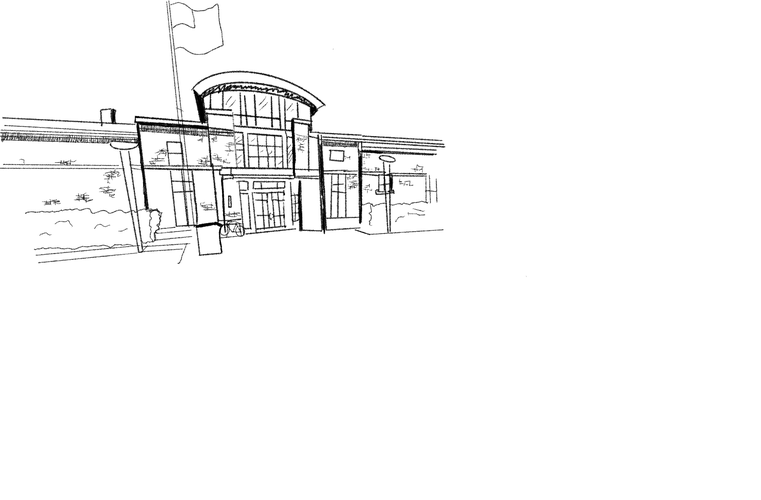
Featured Image Description: Logan Theater on Milwaukee Avenue, north of the Illinois Centennial Monument, located in the actual Logan Square. Photo taken October 29, 2022 by Micah Wilcox.
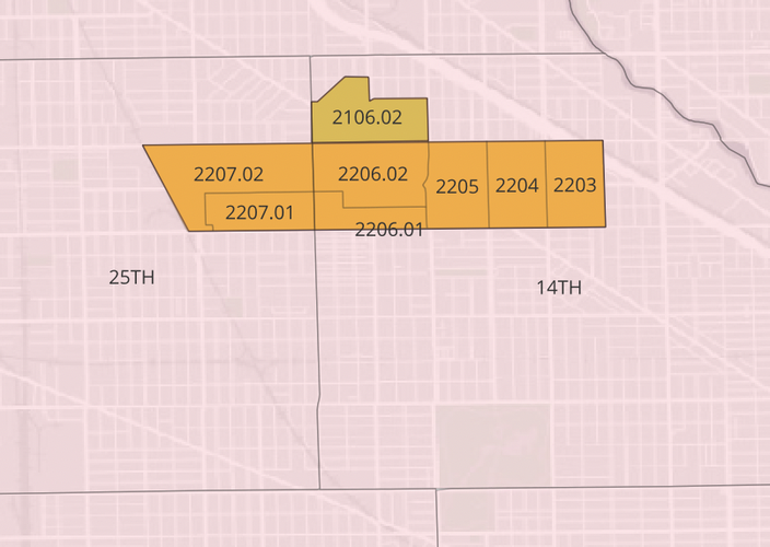
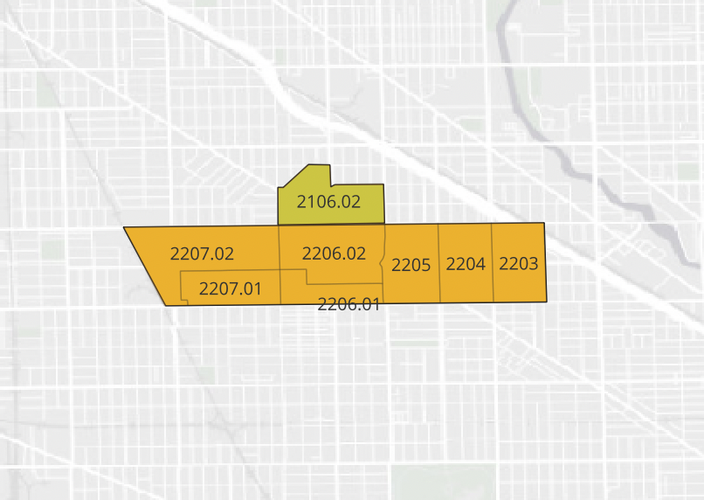
Officially (per the Zolk Google Map), North Logan Square is 0.96 square miles, including in their entirety the census tracts between Diversey, Fullerton, the Metra Milwaukee District-North route, and, for the purpose of this project, I-90/Rockwell (Western Avenue, which Zolk uses as their border, is in the middle of a large census tract that hugs the north branch of Chicago River). However, including Tract 2106.02 – a borderlands area between Logan Square and Avondale that sports the Solidarity Triangle, a park maintained by the Logan Square Chamber of Commerce and the Milwaukee Avenue Alliance, and the headquarters of the Logan Square Neighborhood Association/Palenque (LSNA/Palenque), results in a total area of 1.11 square miles. Note: although I discuss Tract 2106.02 in Overview and Social Mix, I do not include it in my analysis of Public Space, Amenities, or Connectivity, nor is it considered part of North Logan Square in my Final Project.
The population of the core area is 20,622, but with the tract north of Diversey, the population rises to 24,770. These counts reflect Logan Square’s highly dense built form, a form that goes back to its early organization pre-Chicago annexation in 1889. Although the neighborhood is far larger than Jane Jacobs’ conception of “face streets,” North Logan Square is oriented around major street corridors: Milwaukee Avenue (Northwest), Diversey, and Fullerton (East-West). Diversey and Fullerton serve as the streets in the spirit of Talen's conception of “seams" or unifiers between neighborhoods (Neighborhood 2019, 93-95). Fullerton serves as the boundary with South Logan Square and Palmer Square, which is fully surrounded by North and South Logan Square. Diversey serves as the border with Avondale. This concept of “seam” is especially relevant to Diversey, given that Avondale is more distinctly “separate” from North Logan Square than South Logan Square. The “seam” nature of the street – i.e. its operation as a joining force rather than a dividing barrier – is accentuated by the fact that the Logan Square Neighborhood Association (Palenque)’s headquarters is just north of Diversey. On the intersection of Milwaukee and Diversey – just down the block – one can find the Solidarity Triangle, the Logan Square Chamber of Commerce-maintained park whose website declares it “a plaza for the people at the gateway to Chicago’s Avondale neighborhood.”
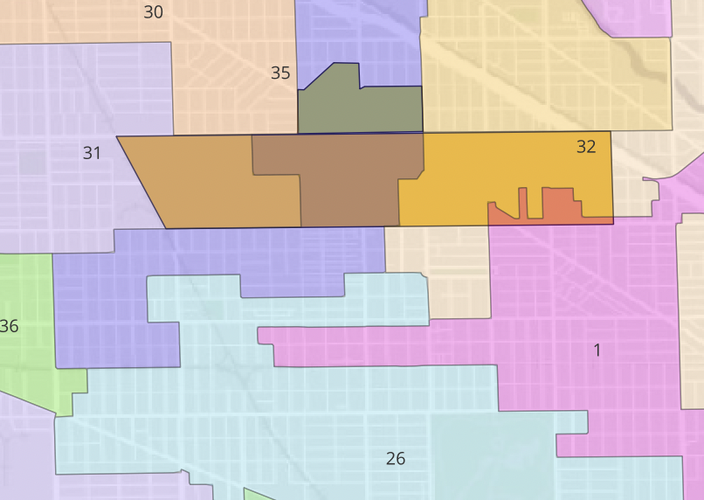
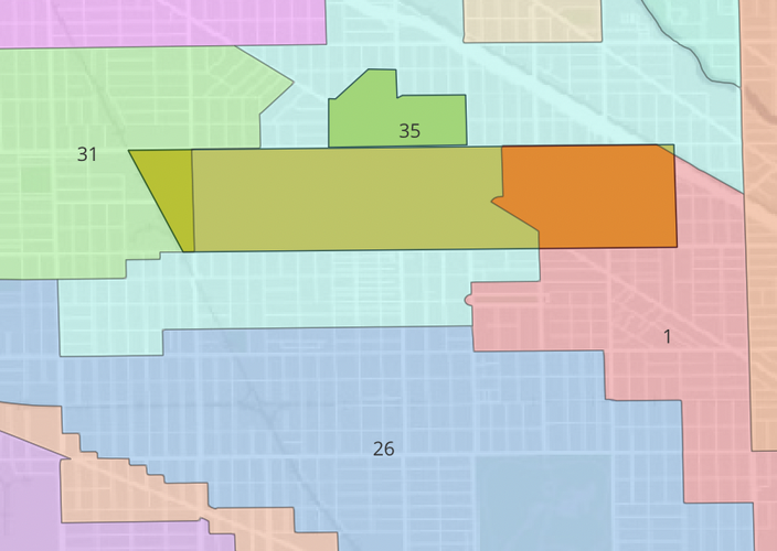
North Logan Square is split into two parts for police precincts and Ward districts. From Albany to Milwaukee to North Sacramento, North Logan Square is divided everything west of those boundaries is in the 1st District, while the rest – including Tract 2106.02 – are in District 35. This represents an increase in the consolidation of North Logan Square in District 35, as its border had formerly been Kedzie to the Illinois Centennial Monument before going South along Sawyer to Fullerton, North Spaulding to Palmer, and then North St Louis to Dickens. In contrast, the 1st District was moved north and west, gaining far more of North Logan Square than the small pieces it had from the 2015 map, while District 32 was moved east, losing North Logan Square entirely. The 25th Precinct of the Chicago Police Department includes North Logan Square west of Central Park Avenue, while the 14th Precinct occupies the rest, including Tract 2106.02.
North Logan Square's history is that of the Logan Square community area. Logan Square was named after General John Logan, a Union Civil War veteran who later served as a Republican senator from Illinois. The area became heavily built up and dense early-on as a northwestern gateway neighborhood for immigrants. The population through the early-20th century consisted mainly of Scandinavians and Germans before they were joined by Norwegians, Russian Jews, Italians, and Poles (a group that comprised 37.8% of the Logan Square Community Area population by 1950, per the 1958 City of Chicago Study of the Logan Square Community Area (City of Chicago 1958, 6)). By 1930, the community area hit 114,174 – its high point, declining to 106,763 in 1950 (City of Chicago 1958, 3), to 71,665 by 2020, according to the Chicago Metropolitan Agency for Planning (CMAP). The neighborhood became heavily Hispanic throughout the late 20th century, with Chicago Studies describing it as populated by Mexican, Cuban, Puerto Rican, and Central American immigrants. The community area became majority white in the 2010s, however, going from 65.1% Hispanic or Latino in 2000, compared to 51.6% White in 2020, per CMAP. This, along with a jump in the median income from $57,888 to $84,653 and a drop in the population by 13.4% from 2000 to 2020 are symbols of gentrification taking place in the community area, an ongoing phenomenon informing current fights about affordable housing.
The history of North Logan Square is a history defined by Chicago central city planning as well as the decentralized actions of individual developers and community organizations. Although the area covered by the community area began as a “prairie farming village,” per Chicago Studies, the area quickly became part of Chicago’s urban area (read: not yet formally part of the city) in the mid-19th century following the construction of Milwaukee Avenue. The area was officially annexed in 1889, by which point the area had become densely populated following the 1871 Great Chicago Fire, something Chicago Studies attributes to its location outside the burn zone. The construction of Milwaukee Avenue and its predecessors, the North and Western Railroad (both of which preceded the post-fire population growth) and then the Northwest branch of the “L” all served as examples of central planning structuring the growth of the neighborhood. The neighborhood was further altered by the late 19th century construction of the Chicago Boulevard system, which reaches its northernmost point at the center of North Logan Square – the square itself, where the 1911 Illinois Centennial Monument stands – and goes East along Logan Boulevard.
Chicago Studies also blames the construction of the Blue Line (chiefly the construction of the underground Logan Square station) and the construction of I-90 for harming the neighborhood as a form of urban renewal. Notably, the 1958 Chicago Community Survey described the area as “completely built up” (City of Chicago 1958, 4) where things could only be constructed following the destruction of existing buildings. Such a statement was unfortunately made true by the construction of the Eisenhower Expressway portion of I-90 in particular, the impact of which is clear through a WBEZ article called “Displaced.”
The Community Survey assessment remains true today; even with a reduced population, Logan Square is highly dense when compared to Hyde Park and Woodlawn. While I-90 still makes a near-formal barrier on the northeast corner of the neighborhood, the Blue Line now serves as the main anchor of North Logan Square to the Loop, much as the Milwaukee branch of the Metropolitan West Side Elevated (one of the pre-CTA transit networks) did. Although the general structure of North Logan Square remains the same, structured along Milwaukee and the L with the boulevards as well as Fullerton and Diversey serving as seams, the neighborhood composition has changed through gentrification, a largely decentralized challenge that city/ward-level policy is only beginning to respond to.
“CMAP Community Data Snapshot | Logan Square - Illinois.” Chicago Metropolitan Agency for Planning. Chicago Metropolitan Agency for Planning, July 2022. https://www.cmap.illinois.gov/documents/10180/126764/Logan+Square.pdf.
Birnbaum, Mike. “Blue Line Station: Doors Open on the Left at Logan Square.” LoganSquarist. January 28, 2013. https://logansquarist.com/2013/01/28/history-blue-line-station/.
Loerzel, Robert. “Displaced | When the Eisenhower Expressway Moved in, Who Was Forced Out?” WBEZ 91.5 Chicago. Accessed October 17, 2022. https://interactive.wbez.org/curiouscity/eisenhower/.
“The History of Logan Square.” Chicago Studies | The University of Chicago. The University of Chicago. Accessed October 17, 2022. https://chicagostudies.uchicago.edu/logan-square/logan-square-history-logan-square.
Morris, John. “A Brief History of Milwaukee Avenue, Part 1: an Indian Trail Becomes Dinner Pail Avenue.” Web log. Chicago Patterns (blog). Chicago Patterns, July 4, 2016. http://chicagopatterns.com/a-brief-history-of-milwaukee-avenue-part-1-an-indian-trail-becomes-dinner-pail-avenue/.
Long, Zach. “Logan Square, Chicago Neighborhood Guide.” Time Out Chicago. Time Out Group Plc, November 12, 2021. https://www.timeout.com/chicago/things-to-do/logan-square-guide-the-best-of-the-neighborhood#:~:text=The%20neighborhood%20takes%20its%20name,large%20homes%20along%20the%20boulevards.
City of Chicago Commission on Human Relations Research Department, “Study of the Logan Square Community Area, February 1958.
Bloom, Mina. “Nearly 700 People Apply For 50 Apartments In New Logan Square Complex, Showing ‘Dire Need’ For Affordable Housing In Area.” Block Club Chicago. July 22, 2021. https://blockclubchicago.org/2021/07/22/logan-square-affordable-housing-700-apply-50-apartments-emmett-street-complex/.
Chicago ''l''.org: Stations - logan square. Chicago ''l''.org. Accessed December 4, 2022. https://www.chicago l.org/stations/logan_sq.html.
When I visited North Logan Square, practically no one was outside the morning of Thursday, October 13th. As I walked around on that chilly day, the only group of people I saw out was at Chiqueºlatte, a Netherlands (and Luxembourg)-based coffee shop whose only non-European location is in Logan Square. I also did not see any gates or signs or bike racks akin to the Hyde Park racks that would serve as an official delineation of community identity. In this context, the main aspect of built form that I see as helping create a sense of neighborhood identity is North Logan Square’s street art.
There is a ton of street art surrounding Milwaukee Avenue in North Logan Square. Exiting onto the Paseo Prairie Community Garden-adjacent exit of the Logan Square station brings you out next to an elaborate Pokemon mural. Later, I came across an alley just north of Diversey of the Beatles. The most visible marker of Logan Square identity came on the side of a coffee shop called The Brewed coffee, in the form of two murals: A dark-skinned Rosie the Riveter flexing her bicep in her signature “we can do it” pose next to a unique, mirrored rendition of the Chicago skyline. Surrounding the upward and downard buildings were different fonts spelling out the names of Chicago’s neighborhoods, with Logan Square done in an elegant cursive font. In between the skylines were a green leaf, a Chicago star colored in with rainbow colors, a crossed-out gun, and a red Black power fist.
Ironically, this mural (painted by @menaceresa) is north of Diversey, just like the LSNA/Palenque headquarters. However, it encapsulates a particular presentation of Logan Square identity as built on solidarity and support for one another against all forms of harm, whether it be discrimination and neglect or gentrification and displacement. It is worth noting that all of these themes are present on the LSNA/Palenque website. The website describes their identity as a community group as being forged in the 1970s and 1980s when the neighborhood became primarily Hispanic and also low-income, as it worked to serve these new residents.
The Brewed mural is thus a uniquely political mural among those that I saw, but all of them act as a form of placemaking that can be interpreted as a sign of community ownership and organization much in the way that gates and signs are interpreted. This theory is especially supported by articles such as the Chicago Sun-Times Logan Square Street Art Guide, which identifies Logan Square as a neighborhood defined by its street art.
With regards to identity, one final note from my initial neighborhood reconnaissance was my observation of an apartment building sporting block letters in its L-facing window reading “livelogan.com.” It was the only major marker of Logan Square that resembled any form of neighborhood branding (particularly when compared to street art that can be interpreted as more organically defining the neighborhood to its inhabitants). This relationship between corporate, gentrifying interests and existing residents and how it impacts Logan Square’s identity for residents and outsiders is something I plan to explore further in later assignments.
Ali, Tanveer. “Logan Square Street Art Guide from The Grid.” Chicago Sun-Times Guides. Accessed October 17, 2022. https://guides.suntimes.com/street-art/logan-square/.
“What We Do.” Palenque LSNA. Palenque LSNA. Accessed October 17, 2022. https://www.palenquelsna.org/about.
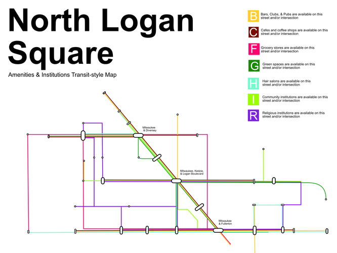
1. https://youtu.be/OB_9QoPf5lY
2. https://youtu.be/8r09I4rQhHA
3. https://youtu.be/I16vVSaCK80
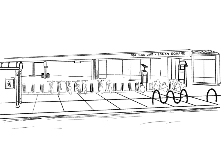
For my section on public space, I replicated Leon Krier's style of drawing to document public spaces in North Logan Square. I also visited North Logan Square on October 29 to better understand how each space was used. What I found was that although each public building and structure is different – with none save the Illinois Centennial Monument in Logan Square itself following Krier's preference for traditional architecture – each was distinct in its design, served a different use-value, and was highly valued by the public.
The Logan Square Blue Line entrance and plaza (located across the street from the Centennial Monument) is more or less transitory, some people in it but most likely for the bus or train. Particularly compared to the two adjoining areas, nothing was happening. Of the public structures, this one is clearly the most utilitarian in design – distinct from the other public structures in that regard – and its use reflects that.
The Logan Square branch of the Chicago Public Library is a sleek, postmodern brick building marked by a curved metallic-looking rooftop crowning the tallest point in the single story building (which is that height to create an open atrium when one first walks in). The library exterior and interior are well-maintained, if not overly ostentatious when one compares it to the expansive Lincoln Park branch or the downtown Harold Washington branch. However, the library was populated with children and adults of all ages in the computer area and the children’s section – there was even someone in the book stacks. The building’s design and amenities were functional – distinct from the other public buildings in North Logan Square, with enough ornamentation and ostentation in design and color to facilitate clear civic engagement on top of the distinct use value when compared to the other spaces discussed here.
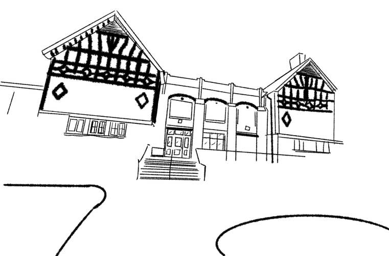
The interior of the Kosciuszko Park Fieldhouse is distinct from the Haas Fieldhouse also discussed in this article in that it is a poolhouse. The exterior, which opens out onto a neighborhood side street and onto the park, is a Tudor-revival structure that is architecturally quite impressive, particularly when paired with the knowledge that it is a public building. When I visited, there was some kind of swim meet going on – I heard whistles and shouting from the building. The park itself wasn’t densely packed but it was lively – individuals, dogs, families sitting, playing, walking around. All in view of the street, where people were walking by and sometimes into the park, and all in view of the Fieldhouse. Once again, I found it to be a unique example of public space that distinguished itself in use-value and design, with the common theme being accommodation of different community needs and a desire to make the structure ostentatious in some way – although this way was especially unique when compared to all the other structures.
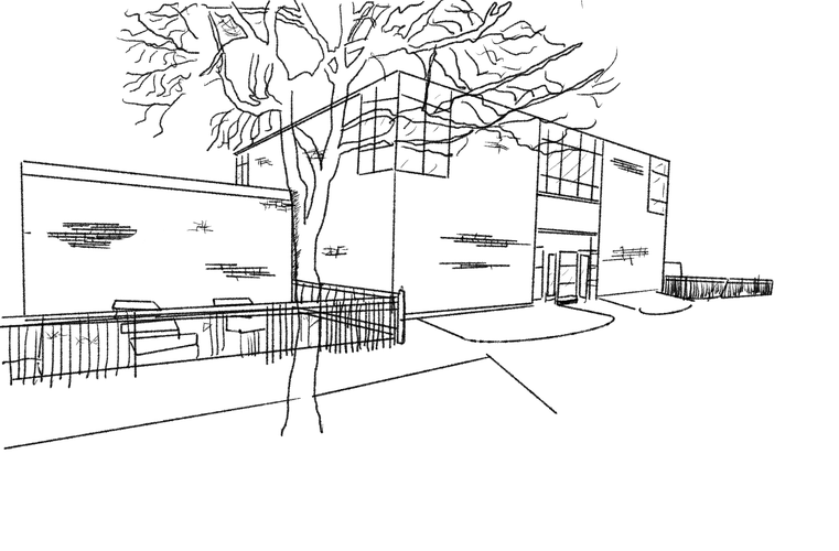
The Haas Fieldhouse is a glass-and-brick modernist structure in southeast North Logan Square, on Fullerton Avenue. The fieldhouse is large in size, particularly for a one story building, but accessible, with doorways opening into the park and onto the street. It is right next to a play structure and a dedicated soccer field. When I arrived at the field on Saturday avenue, more than a dozen kids played at a soccer meet and on the playground, surrounded by parents. Inside the fieldhouse, a child told me the expansive, hardwood gym was closed; although there was an open door to a room of exercise equipment, I did not enter. In what I assume is a multipurpose room, some sort of party was being held with lots of children. This fieldhouse – which more or less resembles the YMCA next to my house in its use-value – and the playground and soccer field that make up the whole complex are clearly embedded in the community as a civic space marked by clean, well-kept infrastructure inside and outside the fieldhouse itself, distinguished from its surroundings by its size as well as its scale. Like the other spaces, distinct design paired with a distinct use value made for a successful combination.
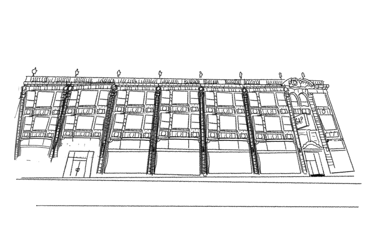
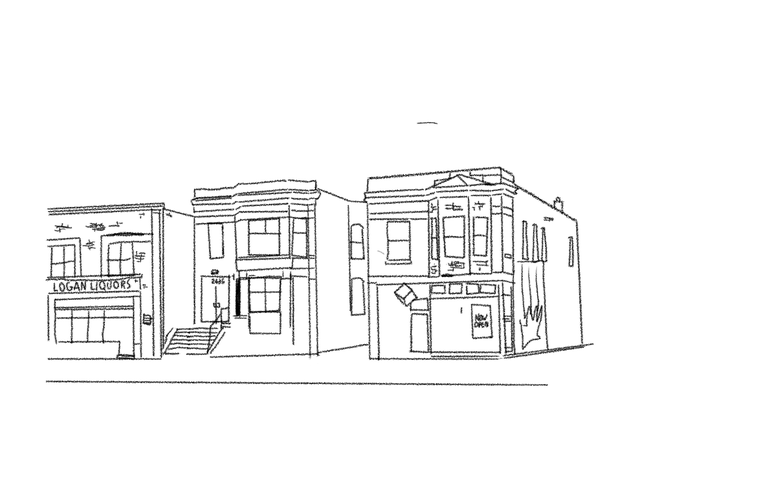
Although not a public space, even in its weakened, post-COVID state with many vacant spaces, Milwaukee, Fullerton, and Diversey (to a lesser extent, as it has lots of residential development) Avenues remained lively, with with people of all ages going about their business by foot, bike, stroller, and car. El Dorado (a thrift store) and Passion House Coffee Roasters (a cafe) both had guests, while I saw multiple groups of people walk around the Illinois Centennial Monument (likely to continue south towards Fullerton). As Krier's diagram dictates, the city is only truly formed when Res Publica and Res Economica are paired together.
The below photos are the Gap on Milwaukee and a collection of private buildings (the rightmost one being Passion House) on Logan Boulevard
The clear valuation of North Logan Square’s diverse public spaces and buildings – structures that run the gamut in design from neoclassical ornament to modernist and postmodernist elegance to Tudor-inspired homage – serves as an implicit rebuke of Krier’s declaration that public buildings and structures – Res Publica – must be uniformly differentiated and elevated above Res Economica through the use of traditional (read: neoclassical) architecture and the restriction of ostentation in Res Economica. The vibrant street life I observed on Milwaukee and Fullerton Avenues, streets marked by wide variation in design and presentation that, rather than overshadowing Res Publica, complemented it by surrounding serves as a further rebuke. Although Krier argues that the city is constructed with both parts, he does not seem to acknowledge the role of res economica in structuring a broader community identity through differentiation and interaction with residents and neighbors. I would be very curious to learn more about his perspective on community organizations and “third spaces” (Oldenburg 1999) such as coffee shops but also on how community is structured by resident-proprietor relationships as well as product and store differentiation in the context of community identity.
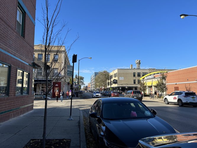
A busy Sunday midday on Milwaukee Avenue in North Logan Square. Photo taken 11/6 by Micah Wilcox.
I observed Milwaukee Avenue from the northern border of Diversey Avenue to the southern border of Fullerton Avenue as the central commercial corridor bisecting my given tracts. This Street is populated by many business chains. These chains range from Chicago-only (Furious Spoon and Black Dog, the latter of which is temporarily closed), to national chains that originated in Chicago (Intelligentsia) to national chains like McDonalds, Target, 7-Eleven, and the Gap. I believe the rest of the stores are local.
Walking along Milwaukee midday Sunday, November 6, I saw people crowding into both local and chain cafes – McDonalds, Intelligentsia Coffee, KFire BBQ (a local Korean barbecue) and Chiya Chai (a local Indian cafe) were all thriving, among other stores as people walked up and down Milwaukee and around Logan Square.
My takeaway is that chains and local stores have a symbiotic relationship on Milwaukee, where traffic to one group benefits (or at least does not hurt) the other. Essentially, foot traffic to Milwaukee benefits all shops. The reason for this collective prosperity is that people are coming to Milwaukee in search of a specific set of goods and services: namely, bars, cafes, and restaurants, among other businesses that have unique flairs and personality when compared to the above restaurants. The vast majority of the chains that I observed on my section of Milwaukee are small (compared to the five I mention) and sell unique goods (single-origin coffee and soon, cannabis-infused brownies) that are more closely related in product offerings and business presentation to local stores than the more conventional goods sold by larger chains like Starbucks (read: not cannabis brownies). In short, the chains and local stores benefit one another because they both help maintain Milwaukee Avenue’s identity as a "trendy" ((Michael 2013) Parker forthcoming, 204)) "cool" (Parker forthcoming, 202), “Bohemian” scene, to cite Terry Clark and Hyeson Jeong in Streetlife (forthcoming) Chapter 10 (Clark and Jeong forthcoming, 227).
Clark and Jeong theorize (along with Silver in Scenescapes (2016) by Clark and Silver) that different urban consumption environments have distinct identities created by the goods and services sold, aesthetics maintained and behaviors performed by businesses and institutions, and area’s built environment. They define Bohemian scenes as being known for demonstrating and enabling “self-expression” and “[transgressive]” behavior, along with a “countercultural ethos” with “aspects of capitalism” (Clark and Jeong forthcoming, 227). They contrast them particularly against “Utilitarian” and “Corporate” (Clark and Jeong forthcoming, 227) scenes, which are far less unique in goods or aesthetic and much more focused on efficient goods and service delivery (think: Starbucks). Milwaukee, as I establish above, is a distinctly Bohemian scene in part due to the types of chains present alongside local businesses.
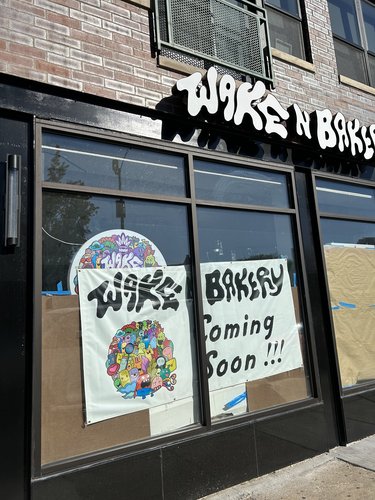
Wake-N-Bakery, "Chicago's Original Cannabis Infused Bakery & Coffee Shop" – https://wakenbakery.net/. A location is under construction on Milwaukee Avenue in North Logan Square, another chain addition to Milwaukee's Bohemian identity. Photo taken 11/6 by Micah Wilcox.
What makes this scene unique when compared to Clark and Jeong’s basic definition is its maintenance in part by chains on Milwaukee. However, it matches trends seen further southeast on Milwaukee Avenue. In Streetlife (forthcoming) Chapter 9, Jeffrey Parker describes a level of “coordination” (Parker forthcoming, 209) occurring between chains and local stores in Wicker Park to preserve the reputation of Wicker Park as a cool, trendy place to visit through channels such as the Wicker Park-Bucktown Social Service Area that utilize funds to support neighborhood businesses, events, and infrastructure, among other initiatives (Parker forthcoming, 209-212). Although my street-level observation is unable to gauge the level of direct coordination between chains and local businesses, my argument for the chain-local business curation of Milwaukee Avenue’s scene (in North Logan Square) is rooted largely in the fact that the chains present are less ubiquitous and smaller than the aforementioned chains and sell trendy items that reinforce the scene of Milwaukee as being Bohemian.
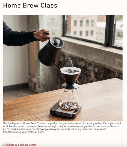
With regards to size, stores like Intelligentsia arguably benefit from simply being smaller and less ubiquitous than Starbucks or Dunkin’, even in its hometown of Chicago. The same goes for Chiqueolatte, a Benelux-based cafe whose only non-European store is in Logan Square; it essentially is a local cafe. It is true that these chains distinguish themselves from larger chains like Starbucks and McDonalds by their smaller size and their more specialized focus (a comparison of Intelligentsia’s website, with its coffee brewing classes and its “Barista’s choice” order option (to say nothing of its far smaller menu) to that of Starbucks/app confirms this argument). However, their presence in Logan Square would have a different effect if they were large-scale enterprises of the level of Dunkin’ and McDonalds. Instead, they “blend in” among the local stores more effectively, creating a Bohemian scene on the basis of selling trendy goods like single-origin coffee and special chocolate bars.
Logan Square is known as a gentrifying place because people were and are attracted to its collection of cafes, bars, and other local venues. These small chains are selling the same goods – such as coffee and unique varieties of food, with a side of self-expression and other tenets of the Bohemian scenescape – as the local stores.
A note: this article is not dealing with the broader impacts of gentrification; it is assessing the relationship between business chains and locally owned businesses, many of which are have opened in the past decade in the midst of Logan Square's ongoing gentrification.
Intelligentsia website offering brewing lessons. Despite being a chain, Intelligentsia offers an interactive activity that can be interpreted as a form of self-expression that, in the context of Milwaukee Avenue, enhances its Bohemian scene.
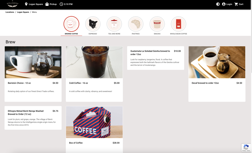
Similar to its brewing classes, Intelligentsia enhances Milwaukee Avenue's Bohemian scene despite being a chain through it's Barista's Choice offering, which highlights the self-expression of individual workers (while also elevating the role of barista from good provider in a more utilitarian coffee shop setting to something resembling a culinary artist).
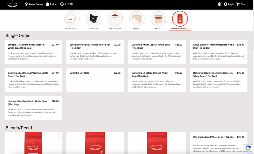
Finally, Intelligentsia's centering of its single-origin beans (beans sourced from a single farm batch rather than mixed together based on general geographic origin or desired flavor profile) further links the chain to a trendy, Bohemian identity that puts the chain right at home among its local neighbors on Milwaukee Avenue.
As mentioned, I don’t know how much of this cooperation is occurring in Logan Square (much less specifically in North Logan Square), but many of the above stores are in the Logan Square Chamber of Commerce, which suggests a level of familiarity with one another. At the same time, it may be largely uncoordinated. For example, businesses like Wake-n-Bakery (which is in the process of opening another store on Milwaukee) may choose to locate in Logan Square because they see the scene as curating a customer base that would frequent their store as a store selling trendy goods (cannabis goods); stores like Starbucks may choose to avoid the location (Starbucks and Dunkin', among other chains, are located in North Logan Square away from Milwaukee) because they may see the scene as making it more difficult for them to compete.
Granted, the five chains I mentioned at the start are exceptions. They may be holdovers from before gentrification became widespread in Logan Square, or, in the case of Target, chose to locate in Logan Square as part of a broader urban expansion strategy. However, their rarity on North Logan Square make it that they do not compromise the Bohemian scene. Instead, they are relatively neutral, with the atmosphere of the entire street defined by the combination of unique and artistic goods and high degree of self-expression in building aesthetics found in both local stores and the majority of chains on Milwaukee, the latter of which are small enough when compared to companies like McDonalds that their presence remains a novelty, not a threat to local identity. Based on these arguments, and given my own observations regarding Sunday foot traffic, I must echo Parker in saying that the majority of chains successfully co-maintain Milwaukee's Bohemian identity alongside local stores.
Menu: https://youtube.com/shorts/iWQXnqCWTOw
Coffee Bean Offerings: https://youtube.com/shorts/6uTnRZcJ4JU
These videos demonstrate the extent of Starbucks' menu in contrast to that of Intelligentsia's.
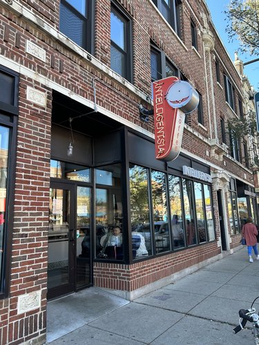
The storefront of Intelligentsia in North Logan Square on Milwaukee, featuring a sign distinct from that of any Starbucks. Photo taken 11/6 by Micah Wilcox.
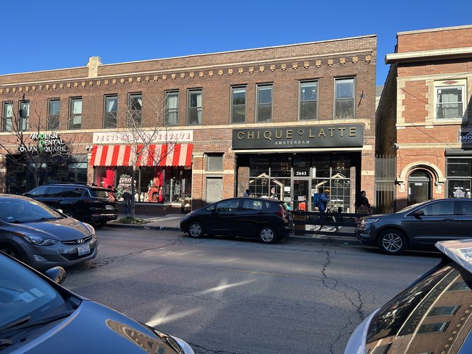
Chiqueolatte on Milwaukee in North Logan Square. This cafe has consistently stood out to me since I first visited North Logan Square for its large amount of patronage (from a street-level view). Photo taken 11/6 by Micah Wilcox.
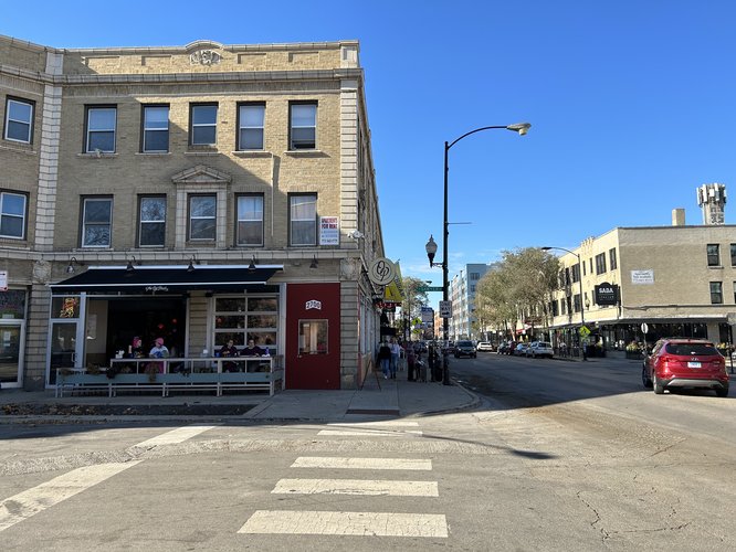
The Old Plank, a local bar and restaurant. Despite being midday on Sunday, The Old Plank was packed, as it had been the Saturday before Halloween. Photo taken 11/6 by Micah Wilcox.
North Logan Square is a highly well-connected neighborhood whose built form largely corresponds to the connectivity standards laid out in the Lexicon of New Urbanism and the Victoria Transport Policy Institute. The reason for this correspondence is that Logan Square overall is a historically dense area whose built form has not changed dramatically since the early 20th century, when most of the buildings were constructed. Per the city analysis done in 1958 in the City of Chicago Study of the Logan Square Community Area, “over 90% of the housing was built before 1930… many buildings were built 60 or more years ago” (City of Chicago, 4) was more or less developed by the 1930s (a time when dense, walkable urbanism was still the standard for American city design). They concluded that only through demolition could new buildings be constructed (City of Chicago, 4). Even while acknowledging North Logan Square’s many surface parking lots (quite a few abutting suburban-style strip malls or warehouse-esque stores), North Logan Square is still arguably a positive example of urbanist and, in the case of its many new developments on Milwaukee Avenue, New Urbanist design standards.
Almost all of North Logan Square follows the Savannah block patterns of a (mostly) grid street pattern with relatively standard block lengths and depths (more on blocks in the Block Types section). Between North Sacramento and Kedzie, the neighborhood shifts to the Mariemont pattern around the northwest-angled North Milwaukee Avenue (with many streets following the diagonal/diagonal until it realigns to the north-south grid.
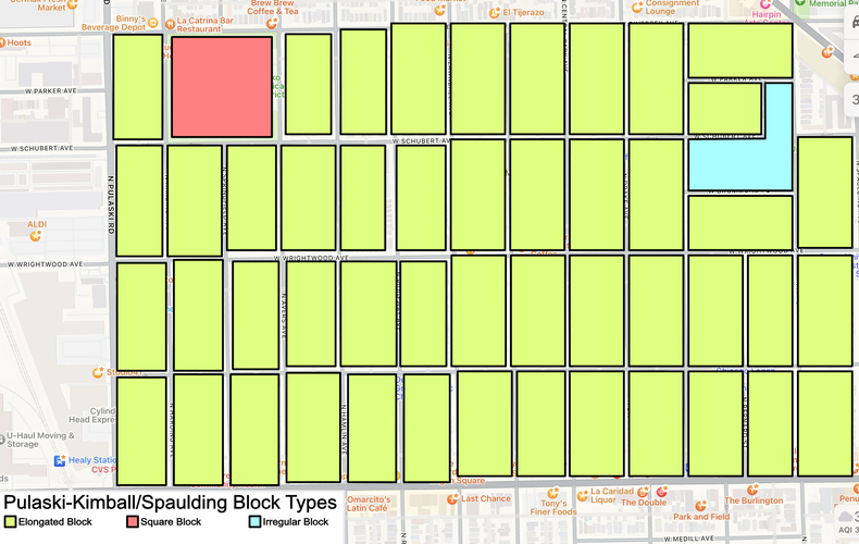
The vast majority of North Logan Square consists of generally uniform elongated blocks. Between North Kimball and Pulaski, and between Sacramento and Rockwell, the built form of the neighborhood is north-south elongated blocks, mainly for residential buildings, flanked on North Fullerton and Diversey by east-west elongated blocks (separated from the aforementioned blocks by alleys) facing both avenues. This uniformity is rarely broken; a square block on Diversey taken up by Kosciuszko Park; an irregular, triangular block where Tract 2203 stretches just north of I-90 and where Sacramento and Milwaukee meet; an L-shaped block including Unity park facing Kimball.
Block types (see color coding) for the blocks between Pulaski to the west and Kimball and Spaulding to the East. As seen here, this part of North Logan Square follows the Savannah pattern of organization. Note: in real life, the blocks are largely the same size and are aligned with each other; however, the grid they are laid out on is not perfectly linear, resulting in a less symmetric map.
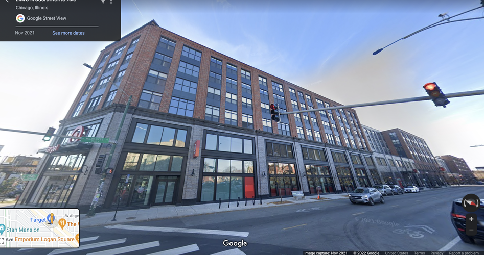
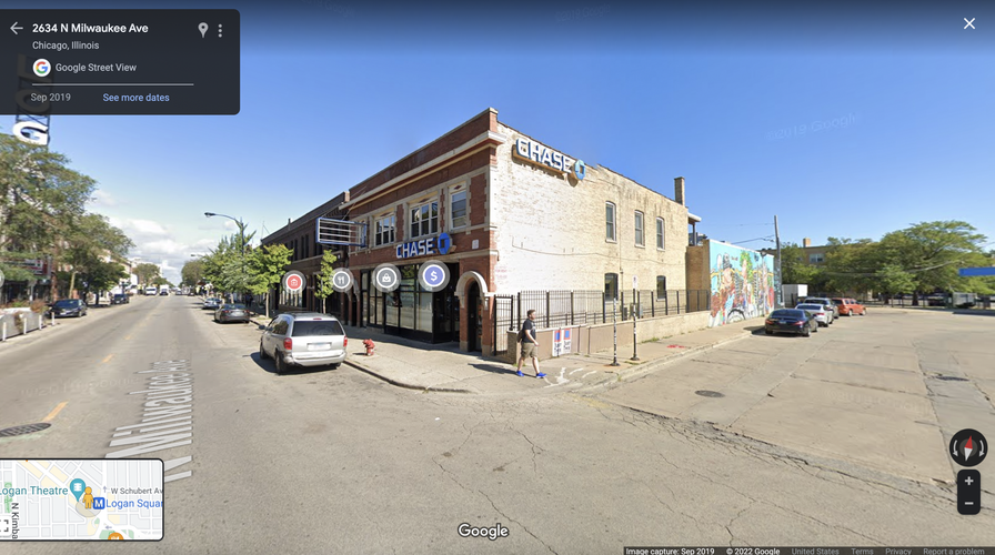
The Target superblock that spans Milwaukee from Sacramento to Logan Boulevard at the Logan Square traffic circle. It is one of the few examples of superblocks in Logan Square.
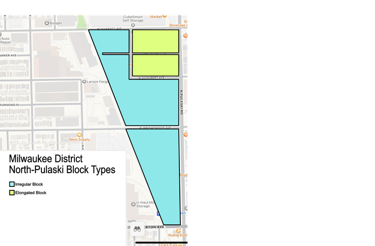
The blocks situated between Pulaski and the Milwaukee District North Metra railway, and around the northwest-aligned Milwaukee Avenue (between Kimball and Sacramento) demonstrate far more variety. The blocks immediately surrounding Milwaukee for the most part are irregular blocks, rhombus, triangular, and other strange shapes molded by Milwaukee, by entirely diagonal side streets, and by diagonal streets that realign mid-block with Chicago’s north-south grid format. There are a few, elongated blocks in this area, all located on Logan Boulevard, Kedzie, or Fullerton.
Block types (see color coding) for the blocks between the Milwaukee District North Metra line to the west and Pulaski to the east.
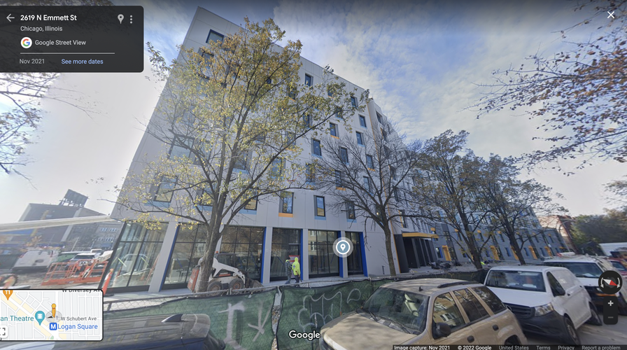
Interestingly, there are three structures that, while oddly shaped, are more distinctive in that they are superblocks/superblock-esque. One (the only true superblock) stretches from North Linden to Logan Boulevard, a singular building with a block-long Target with a single entrance at North Linden (the second block, separated by a short road to a parking garage, has multiple storefronts). Located just north of Logan Square (the square) is a block-long affordable housing complex located behind some commercial buildings.
The affordable housing"superblock"-style complex on North Emmett and the commercial buildings located next to it on Milwaukee.
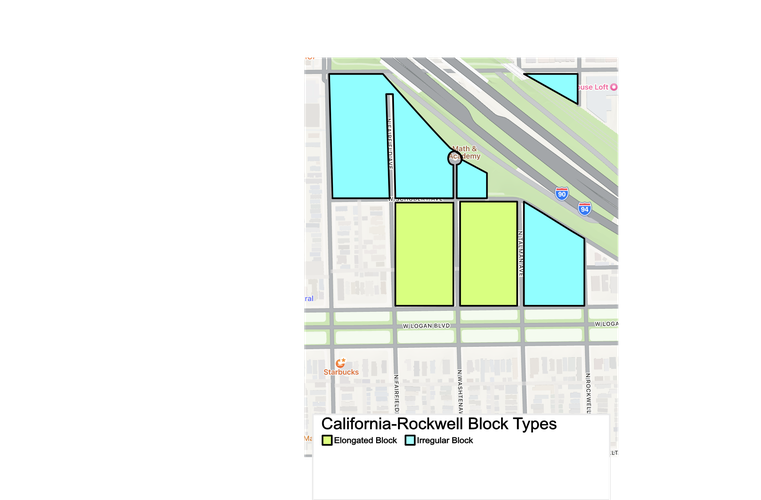
Block types (see color coding) for the blocks between California to the west and Rockwell to the east. There is a single block in North Logan Square separated from the rest of the neighborhood by I-90.
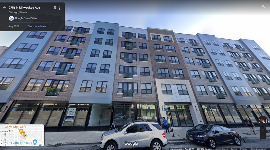
Close to Diversey is a new, Miller Chicago-owned structure with a facade designed to look like multiple, close-together structures even as the first-floor storefronts’ size reveal the illusion. Although it is not a true superblock, I was struck by the size of the building, which is accentuated by its decision to essentially “disguise” it through its appearance.
The Miller Chicago buildings with its facade differentiation attempt.
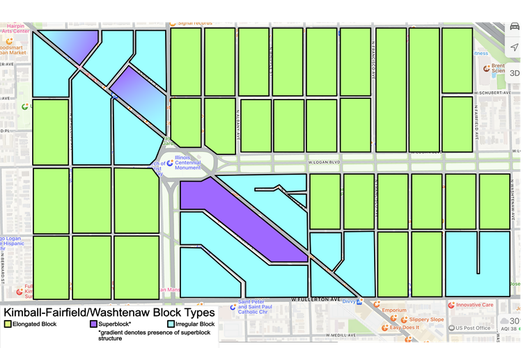
Block types between Kimball to the west and North Fairfield and North Washtenaw to the east. As described, the blocks around Milwaukee are highly irregular in shape, while the network type for these blocks surrounding the northwest-facing road is Mariemont. However, North Logan square's network type returns to Savannah south of West Wrightwood and east of Kedzie the road exiting Logan Square to the north) and Francisco, the road just east of the Milwaukee/Fullerton intersection. The two gradient blocks are the ones with the two superblock-esque structures.
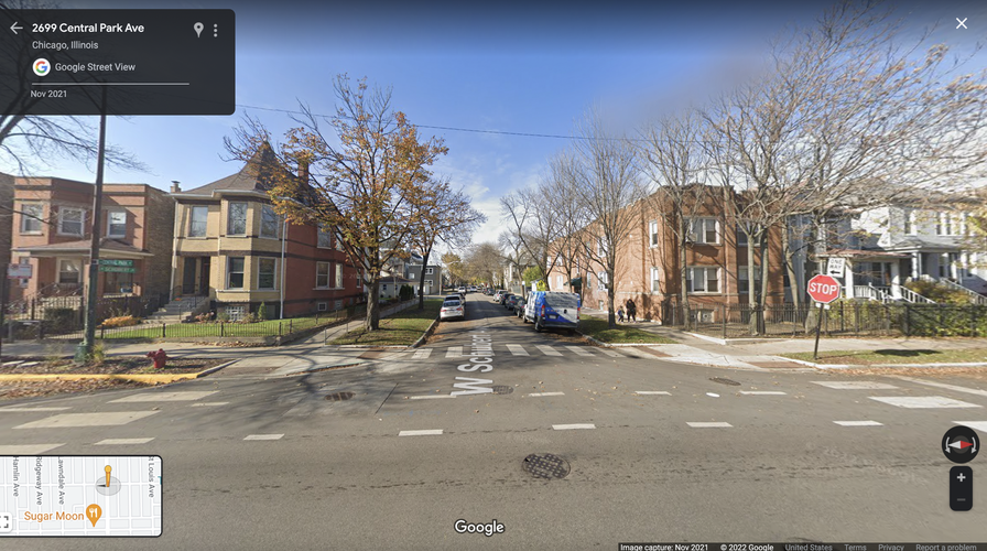
Intersection facing north at Schubert and Central Park. Elongated blocks (like the short sides of two seen in the photo) are by far the most ubiquitous block type in North Logan Square
Almost every street in North Logan Square is just that – a low-traffic neighborhood street. North Logan Square has two boulevards – Logan Boulevard, which goes east from Logan Square and terminates at the Chicago River, and West Wrightwood, a two-lane road that comes into Logan Square from the west and terminates at Logan Square before reappearing east of the Chicago River, making it technically a boulevard in North Logan Square. North Logan Square also has three high traffic avenues – Fullerton, Diversey, and Milwaukee. Although Milwaukee is very busy, it is a two-lane road, as is Diversey. Fullerton is wider at four lanes, making it a real line of division between North Logan Square and South Logan Square and Palmer Square. Although Logan and Kedzie Boulevard (the latter which should be considered an avenue by New Urbanist standards) are also four lanes, they are separated from the sidewalks and buildings by the Chicago Boulevard system that connects to Logan Square (the square) from the south and the east, which gives them a very different feel than Fullerton, where pedestrians are right next to the four lanes.
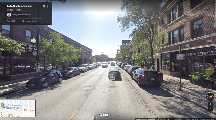
Milwaukee Avenue facing south from just north of Logan Square (the Square itself).
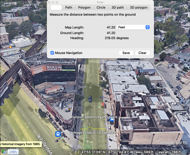
I focus my connectivity analysis on Milwaukee as the high-traffic, most-mixed use corridor completely contained within my neighborhood. Milwaukee Avenue is roughly 40 feet wide, above the 24-36 ft recommended range for pavement (as prescribed by New Urbanist-affiliated planning groups like the Victoria Transport Policy Institute. However, the actual driving space is 18 feet, where 12 feet (six feet on either side) is used for street parking, and eight feet (four on either side) is reserved for bike lanes.
Length of Milwaukee Avenue just north of the Milwaukee-Fullerton intersection.
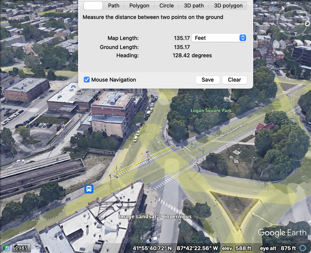
The largest crosswalks in North Logan Square are located at the roundabout around Logan Square, a roundabout that may be changed in the near future to increase pedestrian space. Right now, the three longest crosswalks on Milwaukee (and in North Logan) are the southwest and southeast diagonal crosswalks on Logan Boulevard and Milwaukee (to get to the square) at roughly 130 and 95 feet each, as well as the northeast crosswalk from the northeast corner of the square to the block on Kimball's east side at around 100 feet long. Despite their length, they remain below the New Urbanist-recommended maximum of 350 feet for pedestrian connections.
The crosswalk between Logan Square and the southwest block facing Milwaukee. This crosswalk is longer than the one between Logan Square and the southeast block facing Milwaukee because the southwest block is located further back from the square.
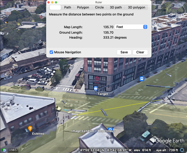
There are three intersections on Milwaukee – Milwaukee and Sacramento, Milwaukee and the southern curve of the Logan Square roundabout, and Milwaukee and the northern curve of the roundabout. The largest of these is the Milwaukee/Sacramento intersection, which has a diagonal width of about 135 feet at its widest point. The intersections around Logan Square, while made smaller than they would be due to the presence of pedestrian islands in the street, are still large. The length at the longest point of the intersection between the southern curve of the Logan Square roundabout and Milwaukee is the aforementioned southeast crosswalks (which are different lengths because the eastern block on Milwaukee terminates closer to Logan Square than the western block), which has a diagonal length between the square and the western block of around just over 130 feet – well smaller than any of the New Urbanist intersection width standards (smallest: 300-400 ft) despite being a major street.
The Milwaukee-Sacramento intersection, featuring the entrance to Target.
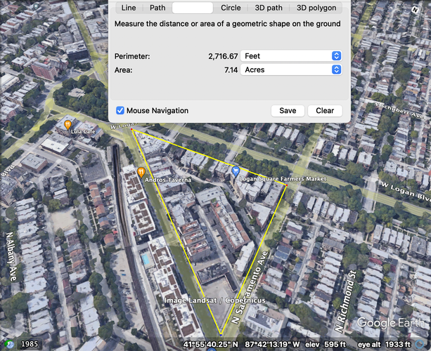
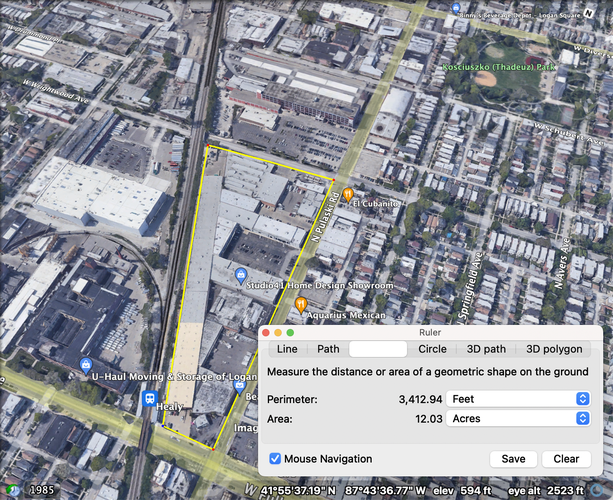
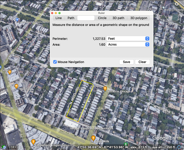
In terms of block size on Milwaukee, the largest block – the triangular block between Logan Square southeast of Logan Square – is just over seven acres. Looking at the whole neighborhood, the general lengths for blocks in North Logan Square go from around one acre to over three acres for blocks, and around one to five acres for some of the larger irregular blocks surrounding Milwaukee. The blocks near the Healy Metra station (Milwaukee District North) consist of large-footprint stores and warehouses, making them an anomaly compared to the rest of the neighborhood (largest plot: just over 12 acres). In short, the vast majority of blocks are far smaller than the recommended New Urbanist/Victoria Transport Policy Institute block size range of 5-12 acres.
With regards to other connectivity standards, I identified only one true cul-de-sac, right where a street terminates due to I-90. There were a couple of streets that are not fully through streets (these and the true cul-de-sac are identified within irregular blocks in my block type diagram), but there are very few of them.
The largest block on Milwaukee Avenue.
The largest block in North Logan Square
A typical elongated block in North Logan Square
North Logan Square has shifted very little in its physical design since the mid-20th century, with not an over (with the Target apartment complex’s parking garage standing as a notable exception). It conforms to and even exceeds to New Urbanist/Victoria Transport Policy Institute design standards for connectivity and urban form, and I see it as a highly connected neighborhood in terms of thoroughfare, network, block, and specific design patterns.
Although Logan Square is connected by the Blue Line to O’Hare and the Loop (and of course, everything in between, including close-proximity stops on Belmont and down Milwaukee Avenue), Logan Square lacks east-west rapid transit connection on Fullerton Avenue. I have biked from the Red/Brown/Purple Line Fullerton Stop in Lincoln Park to Logan Square and back twice now because it is more convenient for me to take the Red Line up to Fullerton and bike west when I am in Streeterville rather than go back south across the Chicago River to take the Blue Line. While riding, I have observed heavy car traffic on the four lane road. Although Fullerton already has lots of stores and homes on both sides of its street (in North Logan Square, South Logan Square, and for much of the way to the Fullerton Red/Brown/Purple station, save for exceptions like the Riverpoint strip mall), I wonder what the connectivity of the broader area would be if an east-west rapid transit (rail or bus rapid transit) line was established along Fullerton.
North Logan Square (NLS) is gentrifying, turning it into a largely white, high-income neighborhood filled mainly with amenities serving newcomers’ desire for urban consumption experiences. The area is losing its historic Latino identity while its orientation towards the consumption desires of high-income residents – desires that do not include affordable housing, non-consumption-based economic activity, and grade 6-12 public schools – forestalls future diversification.
Social diversity results from ample housing choices for all incomes, a range of economic activities that can employ people with different educations / skillsets, and good public schools that enable families to raise children in a neighborhood while also providing forums for community engagement. Preserving / increasing social diversity in NLS can only be done by changing the built environment to make all three concepts available and accessible for current and new residents. Because NLS is almost entirely built up already, this means new development must be built vertically, with multi-use structures to take advantage of each parcel. I call this argument "Flexible Urbanism."
The most effective way to construct unsubsidized affordable housing in NLS is to change zoning rules to build mass timber towers in NLS’s vast single-family only zones. Mass timber costs less than concrete/steel despite offering the same strength, and mass timber structures can be far taller than the(“5 over 1”) wood / concrete podium structures often used for affordable housing. Thus, economies of scale in apartment construction can be reached vertically, ensuring efficient parcel utilization and lots of affordable units.
The majority of NLS businesses (that I observed on Fullerton/Milwaukee during this project) are single-story retail / consumption businesses. Increasing uses to include creative (sound stages and editing, prototyping equipment, bioscience and manufacturing, general office space) means more people can live and work in NLS. This can be done through tall, multi-use commercial buildings that are built to handle different uses based on their materials and design. Creating buildings with specific leaseholder in mind – concrete/steel construction for bioscience research and manufacturing (potentially in the style of this SGA mockup for bioscience work), mass timber for creative work and office space, all with ground-floor retail to ensure street “activation” (Seal 2018) – will diversify NLS’s economic output and thus, NLS’s residents.
NLS has two public elementary schools. Constructing one+ middle and high schools in NLS would increase the neighborhood’s hospitality to families while also strengthening NLS’s identity. By keeping K12 education entirely within the physical bounds and social context of the (diverse) neighborhood and by providing more formal (local school councils) and informal (extracurriculars, community events on school grounds, etc.) for community engagement, adding middle and high schools ideally can strengthen community identity to support diversity and resist homogenizing forces.
NLS exemplifies two urban development challenges: first, ongoing gentrification homogenizing the neighborhood’s residents / economy; second, a compact, already built-up landscape that means every parcel must be maximized. Building more affordable housing and space for different economic activities lays the groundwork for neighborhood re-diversification, as does building more schools while also providing more forums for diverse community organization to resist future homogenization. Flexible Urbanism, constructed by building vertically with mass timber for housing and flexible materials/design to accommodate different businesses makes the most of NLS’s limited space to produce large amounts of unsubsidized, affordable housing and business space alongside schools designed to support a growing, diverse population.
3. Demsas, Jerusalem. “In Defense of the ‘Gentrification Building.’” Vox. September 10, 2021. https://www.vox.com/22650806/gentrification-affordable-housing-low-income-housing.
4. “The Vertical Cluster.” SGA. SGA, November 2, 2020. https://www.sga-arch.com/projects/the-vertical-cluster/.
5. Seal, Rachel. “Main Street Fever.” Web log. Hames Sharley (blog). Hames Sharley, December 7, 2018. https://www.hamessharley.com.au/knowledge/main-street-fever.
6. Peña, Mauricio. “Want to Get Involved in Chicago’s Local School Councils? 5 Things to Know.” Web log. Chalkbeat Chicago (blog). Chalkbeat, September 1, 2022. https://chicago.chalkbeat.org/2022/9/1/23333494/chicago-public-schools-local-school-councils-vacancies-raise-your-hand#:~:text=Local%20School%20Councils%20have%20been,voted%20on%20every%20two%20years.
Note: My project is titled Flexible Urbanism, but it is unrelated to existing discourse surrounding the term.
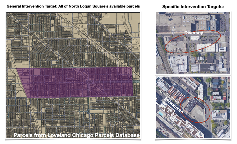
My target intervention is all of North Logan Square, represented here by distinguishing parcels in my neighborhood from those in Chicago at large, but I have chosen to highlight specific areas on Diversey and Milwaukee Avenue (seen in the two photos). Although each intervention is to be applied across all parcels as they become available for development (particularly my first intervention, the upzoning/zoning streamlining and the use of mass timber), I identified two seemingly vacant areas that could be immediately used for my third intervention, the creation of community services such as schools. Photos from Google Maps, parcels from Loveland Chicago dataset; polygon covering North Logan Square area made in QGIS.
Streamlined residential zoning map compared against old zoning map, where the bulk of North Logan Square’s residential areas are upzoned and given two potential classifications: B2-5, or "neighborhood mixed-use district" (Second City Zoning) that also allow by-right ground-floor housing units, or RM-6.5, fully residential structures. Both classifications allow for the highest floor-area ratios for their classification (6.6 and 5, respectively), with discretion allowed for height (for RM-6.5, "tall buildings require planned development approval," per Second City Zoning). Having the choice between similar, but exclusively residential or mixed-use zoning designations offers flexibility to current and parcel owners for their development plans. Graphic for Intervention One. Made in QGIS. Zoning information from Second City Zoning and the City of Chicago). Official Chicago zoning code found here.
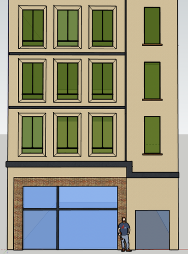
Mockup of the facade of the first four stories of a 32ft x 122ft, ideally mass timber-based tower that could fit into the narrowest parcels in North Logan Square’s residential neighborhoods. Based on narrow building designs such as the Capital Core structure in Seattle, Washington. Graphic for Intervention One. Made in Sketchup.
Streamlined commercial zoning map compared against old zoning map that breaks North Logan Square into four categories: B3-5, or "Community Shopping District" (Second City Zoning), the highest classification for non-explicitly vehicle-oriented business types, along two-way streets within the RM-6.5/B2-5 zones; C1-5, or "auto-oriented commercial" (City of Chicago 2019, 7) businesses, along Milwaukee, Diversey, Logan, Fullerton, and California; C3-5, or no-residential commercial (both prior designations are residential-inclusive) for zones bordering industrial areas, and M2, or light industry. The four zones are meant to provide flexibility in economic activities while still separating uses and intensity of economic activity based on potential vehicle traffic, proximity to residences, and, in the case of the M2 zone, noise. Graphic for Intervention Two. Made in QGIS.
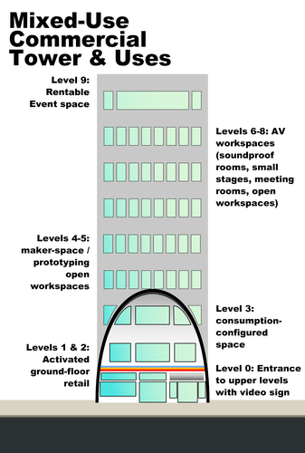
A 9-story tower intended for either the highest designation of neighborhood business district (B3-5) or commercial district (C1-5/C3-5) with use breakdown by floor to demonstrate the idea of vertical, multi-activity/use business structures. Graphic for Intervention Two. Photo from Google Maps, graphic made in Affinity Designer.
Planned junior high and high school area map (with footprints for specific buildings and uses) in northwest North Logan Square in a currently industrially-zoned district. The map would occupy what appears to be two parking lots and the current location of a Hoots at the Fields, which would ideally move to the unused parcel just east of the east-most academic building. Graphic for Intervention Three. Made in QGIS.
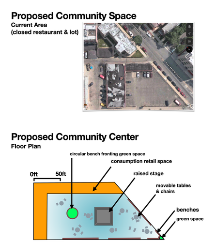
Floor plan comparison against existing, unused lot on Milwaukee Avenue detailing the intended design of an indoor, public community space. Graphic for Intervention Three. Photo from Apple Maps. Made in Affinity Designer.
Social Mix
Demographic Analysis
Looking at demographics for North Logan Square (with and without Tract 2106.02, the Avondale/Logan Square border tract) as well as the Logan Square Community Area, the Northwest Side, and Chicago at large, my main takeaway is that none of these areas are racially/ethnically diverse. I recorded eight categories for race/ethnicity: White Alone, Black or African American Alone, American Indian or Alaska Native Alone, Asian Alone, Native Hawaiian or Other Pacific Islander Alone, Some Other Race Alone, Two or More Races Alone, and Hispanic or Latino. Only one location scored above ⅜; the City of Chicago, which scored 3.56/8. North Logan Square (sans Tract 2106.02) scored 2.39/8, while North Logan Square with Tract 2106.02 scored 2.44/8. The Logan Square Community Area (as approximated by census tracts) scored 2.47/8, the Northwest Side (similarly approximated by census tracts) scored 2.55/8. In short, no area I observed is incredibly diverse, but North Logan Square in particular is not diverse when it comes to race / ethnicity both from an objective sense (looking at its Simpson Diversity Index score), but also when compared to Chicago at different spatial levels.
This lack of racial/ethnic diversity contrasts with the high level of diversity I observed at all levels for income. It also contrasts with the relatively high level of diversity I observed at all levels for education for residents. With 16 household income divisions (with incomes adjusted for 2020 inflation) and eight education divisions (for residents 25+ years old), Chicago at large scored 13.49/16 and 5.17/8, respectively. North Logan Square sans Tract 2106.02 scored 12.08/16 and 4.21/8, while North Logan Square with Tract 2106.02 scored 12.01/16 and 4.34/8. Similarly, the Logan Square Community Area scored 11.58/16 and 4.52/8, and the Northwest Side scored 12.71/16 and 4.92/8. Interestingly, the entire community area had the least income diversity, while both North Logan Square configurations had the lowest levels of educational diversity, although the difference compared to the other scales of analysis is not especially pronounced. Similarly interesting is North Logan Square and Logan Square Community Area’s lack of age diversity when compared to the Northwest Side and the city at large. With 12 age divisions, North Logan Square sans Tract 2106.02 scored 5.94/12, North Logan Square with Tract 2106.02 scored 6.21/12, and Logan Square Community Area scored 5.7/12, while the Northwest Side and the City of Chicago scored 8.91/12 and 8.77/12, respectively. Even so, the fact that both versions of North Logan Square score above eight for income and (barely) above four for education leads me to declare the neighborhood income and (somewhat) educationally diverse, even as it is decidedly not diverse racially/ethnically or age-wise, phenomena I intend to research further if this project allows me to.