Overview
Social Mix
Public Space
Amenities
Connections
Final Project
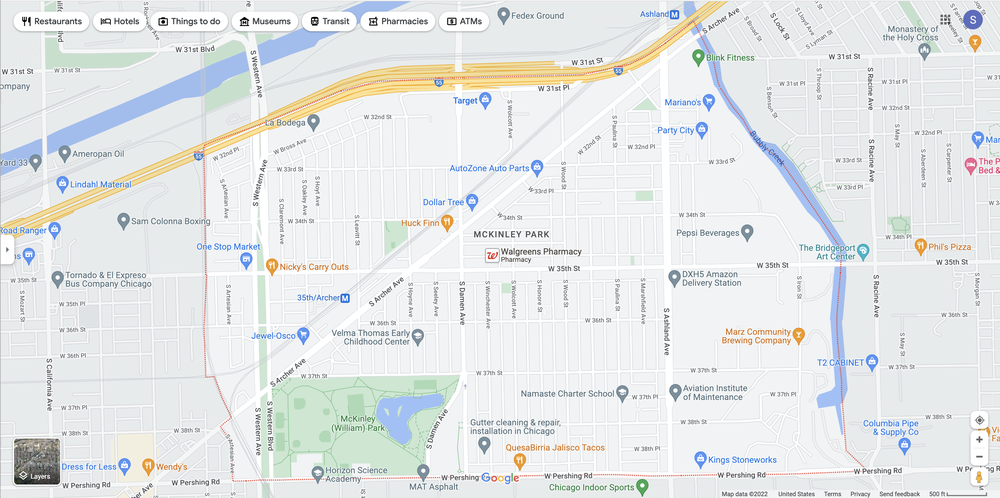
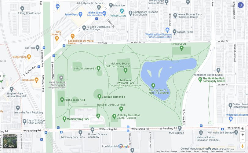
McKinley Park's namesake is perhaps its most prominent public space. It is located in the southwest corner of the neighborhood, sandwiched between a major green vehicular boulevard (Western Ave) to the west and a major N/S street to the east (Damen Ave), while tangent to the neighborhood's main diagonal arterial road: S Archer Avenue.
It enjoys a full suite of amenities: a skating rink (closed for the season), multiple softball/baseball diamonds, pristinely manicured soccer fields, a dog park, basketball courts, tennis courts, and even a lagoon (suitable for recreational fishing!).
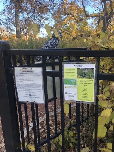
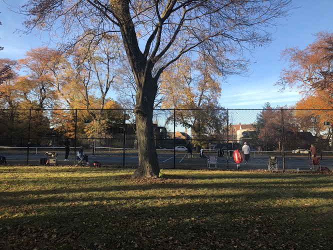
I strolled through the park on a sunny Friday afternoon in October, and observed many of these spaces being well-used. Families, groups of teenagers, and older adults all enjoyed separate zones of activity. A man and his young son popped around the tall grasses near the lagoon, equipped with fishing gear (much to my surprise). The tennis courts were occupied by a large group of middle aged men, all intent on their games. I almost collided with a trio of soft-spoken teenagers when turning a corner on the path through the park's designated natural area. Posted signs and temporary flyers alerted park visitors to McKinley Park's identity, status as a public park and natural area, expected behavior, and imminent natural area management practices. One flyer even entreated visitors to "join your neighbors in planting, pulling weeds, and picking up trash at scheduled 2022 workdays." No single "zone" appeared entirely bereft of visitors or maintenance.
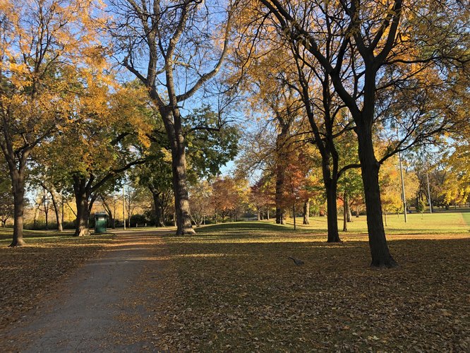
And yet, despite all of this activity, it felt almost quiet. I never felt that the solitude of my stroll was impeded. This is certainly due in large part to the park's size, for it is massive—Google Maps describes it as "sprawling," which I think is a particularly apt descriptor. The park is designed to accommodate all of these separate activity spaces, and it does so without nudging its patrons together or towards any central meeting space; in this sense, it did not seem designed to induce serendipitous socialization. This distinct separation of spaces might also pose safety problem at "dead" times of day/night—I visited on a weekday afternoon, presumably less busy than a weekend but busier than many other times of day. Further observation (and at different times of day) would be needed to assess what effect if any the park's size and relative lack of activity density has on perceived safety. The park as a whole is very well-maintained and aesthetically pleasing—especially on an autumnal afternoon what with the golden light, winding paths, brilliant leaves and neatly kept lawns); the aforementioned flyer entreating neighbors to join weekly clean-ups certainly seems to indicate that these are features the neighborhood takes pride in.
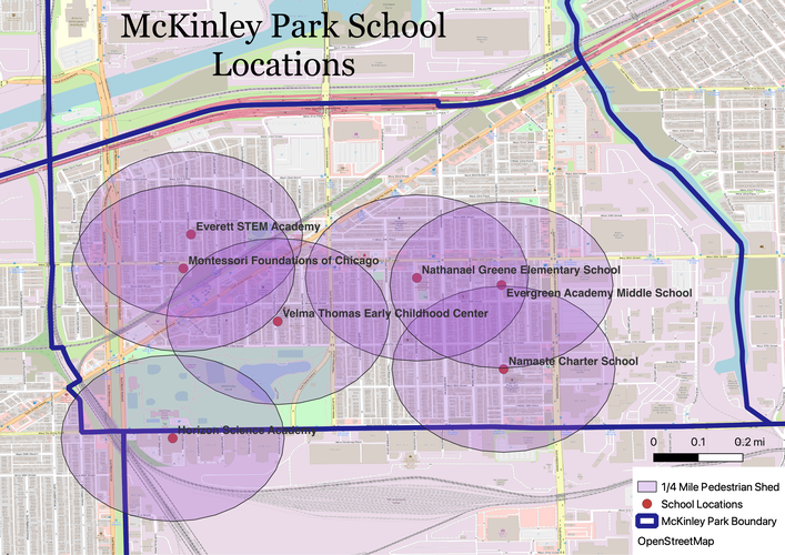
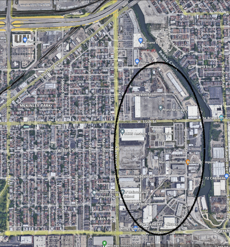
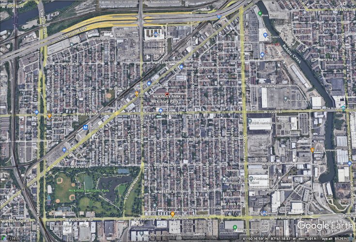
There are 7 schools within McKinley Park's limits—one private (Montessori Foundations of Chicago), two charter (Horizon Science Academy and Namaste Charter School), and four public (Everett STEM Academy, Velma Thomas Early Childhood Center, Nathanael Greene Elementary School, and Evergreen Academy Middle School). Thomas is a preschool, Montessori is an infant through elementary school, Everett and Greene are pre-K/elementary schools, Namaste is an elementary/middle school, Evergreen is a middle school, , and HSA is the neighborhood's only high school (serving grades K-12). The cumulative pedestrian shed of these seven educational centers covers the majority of residential areas in McKinley Park. Only one school is north of 35th street, and all are west of Ashland—east of Ashland (to the community area's east boundary at Bubbly Creek) is almost entirely non-residential, industrial or commercial areas (as the Google Earth visual highlights below, see the circled area).
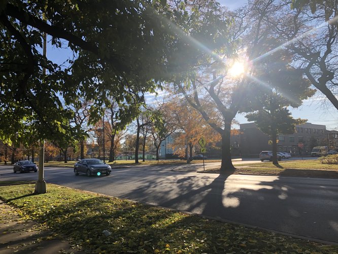
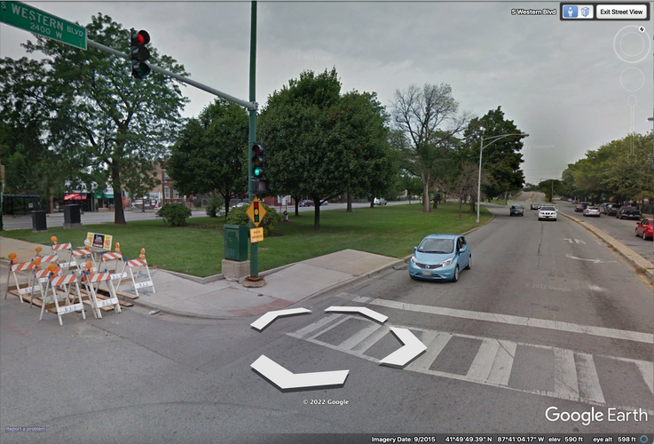
Some residential pockets are outside the reach of the combined school pedestrian shed—the northeast triangle between Archer and Ashland is one such example, as is a small portion between Damen and Wolcott at the southern edge of the neighborhood and residences to the immediate west and south of the Target/adjacent parking lots at the north edge of the neighborhood. Western is a large vehicular boulevard (pictured below).
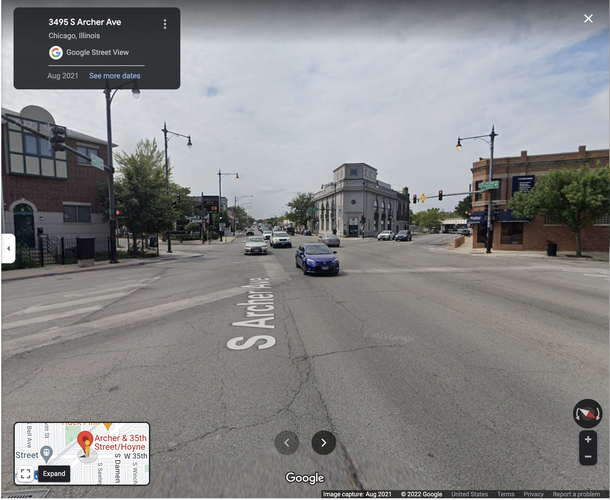
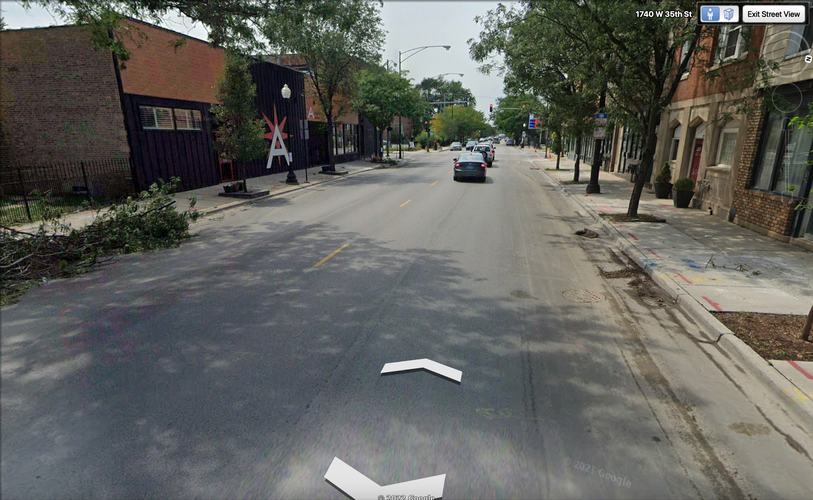
This presents some accessibility difficulties for residents who live west of Western (and east of the train tracks, the community area's western boundary), where no schools are located. While an afternoon stroll down 35th street (one of McKinley Park's main arterial roads) revealed that many parents of Nathanael Greene students feel comfortable walking their children home from school, Western Avenue is quite a bit more intimidating for pedestrians (particularly those corralling small children). Of the other three main arterials in McKinley Park, Ashland (5 lanes) intimidating for pedestrians, but—as very few residences exist to its east—poses less of an accessibility issue. Damen is about as trafficked as 35th street and is similarly accessible for pedestrians. Archer (4-6 lanes?) is perhaps the most concerning in terms of pedestrian access. Pictured below is a Google Street View shot facing southwest down Archer at the 6-way intersection of Archer, Hoyne, and 35th.
Fortunately schools exist on both sides of Archer, although only 2 (one private, one public) are to its northwest while the other 7 are to its southeast. Ultimately, I would estimate that a large majority—from 80-90%—of McKinley Park residents live in the combined pedestrian shed of these 7 schools. Families whose school trek involves crossing Western Avenue, Archer Avenue and/or navigating the small central triangle formed by Archer/Damen/35th likely have the least pedestrian-friendly school commutes within McKinley Park, although they are certainly still doable.
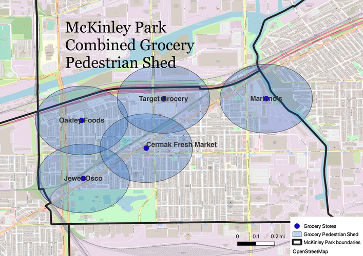
McKinley Park has 5 grocery stores: Jewel-Osco, Oakley Foods, Cermak Fresh Market, Target Grocery, and Mariano's. The combined grocery pedestrian shed covers all of residential McKinley Park with the exception of the substantial southeast area between Damen and Ashland and south of Archer. The Mariano's is located in a strip mall off of Ashland (more vehicle-friendly than pedestrian friendly), and the Target is situated across one of two busy arterials (Archer or Damen) for most residents in addition to being situated behind a substantial parking area, making these two groceries less safe and comfortable for pedestrians to access. Due to the significant southeast area excluded from the pedestrian shed, the combined grocery pedestrian shed is smaller than the combined school pedestrian shed. I would estimate that about 60-70% of McKinley residents live within the combined grocery pedestrian shed.
Overall, McKinley Park residents enjoy a daily-life-needs pedestrian shed that covers the majority of the neighborhood. Residents enjoy choice both for education (7 schools) and groceries (5 stores). My assessment is therefore that McKinley Park is (mostly) walkable.
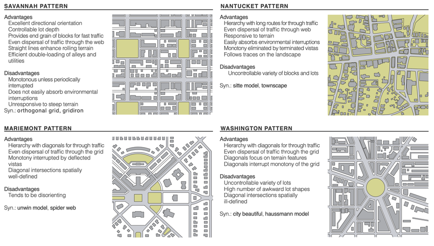
While McKinley Park extends from the train tracks to the west to Bubbly Creek in the east, the predominant (and most regular) street pattern exists in the rough square between S Western Avenue (west) and S Ashland Avenue (east). This area can be dissected into quadrants. In particular, the southeast quadrant formed by 35th, Ashland, Pershing and Damen presents a perfectly uniform grid-iron pattern (also referred to as the Savannah Pattern), distinguished by perfectly consistent street directionality and even lot shape and depth. Outside of the square 35th/Ashland/Pershing/Damen square region, this uniformity is complicated by McKinley Park's diagonal arterial, S Archer Avenue, which bisects the neighborhood into its northwest and southeast portions. While this deviation from the grid-iron neighborhood standard is significant, it is the exception; the neighborhood web is predominantly organized around that orthogonal grid. And, if it were not Savannah, what would McKinley Park's street network be? The Lexicon of the New Urbanism presents six possible network types, pictured below.
Radburn and Riverside patterns can be easily excluded from consideration, as McKinley Park has predominantly linear thoroughfares, fairly consistent lot size/shape, and cul-de-sacs only in its eastern industrial section. Mariemont, Washington, and Nantucket all feature diagonals such as Archer Avenue. However, there are very few deflected vistas, and multiple diagonal thoroughfares in a spider-web configuration are not the primary organizing mechanism (excluding Mariemont). In addition, the vast majority of McKinley Park's street pattern is directionally uniform and not overly responsive to any sort of variable terrain (excluding Nantucket). This leaves the Washington Pattern (city beautiful, Haussman model), characterized by diagonals focused on terrain features, interrupting "the monotony of the grid," and leaving a number of awkward lot shapes. Diagonals disrupting an otherwise uniform grid: this certainly seems reminiscent of Archer Avenue's relationship with the general street pattern of McKinley Park. Add to that the cramped nature of lot shapes near Archer and the park of McKinley Park being tangential/almost pointed at Archer, and it seems fair to suggest that the network type of the majority of McKinley Park is something between the uniformity of the Savannah pattern and the diagonals characteristic of the Washington pattern. East of Ashland and west of Bubbly Creek (the neighborhood's eastern boundary) is the more industrial part of McKinley Park, and the street pattern subsequently breaks from the rigid grid-iron to something looser and more responsive to the terrain (especially the river), creating a variety of block and lot types reminiscent of the Nantucket Pattern.
The block type is elongated blocks for the majority of McKinley Park, although the Google Earth snapshot illustrates how some commercial and industrial areas have a more irregular block pattern.
Thoroughfare types: the larger thoroughfares are individually discussed for their pedestrian accessibility in the Amenities section of this neighborhood profile. They include Western Ave, 35th Street, Ashland Avenue, Damen Avenue, Archer Avenue, and Pershing Road. Stevenson Expressway (inaccessible to pedestrians) forms the northern boundary of McKinley Park. It alone is considered an expressway (variant of a highway). The vast majority of McKinley Park's roads can be characterized as streets built for low vehicular speed and capacity. Examples include E/W 36th and 37th Sts and N/S Winchester and Wolcott Avenues. Between these two benchmarks exist the six major thoroughfares mentioned above in the intermediary categories of "Avenue & Connector" and "Boulevard." The primary distinction between these two thoroughfares is that the boulevard is designed for slightly higher vehicular capacity and speeds (and equipped with slip roads "buffering sidewalks and buildings") and "Avenues are finite in length and its axes are terminated." As all five extend outside of the neighborhood (although Damen is interrupted between Pershing and 47th by an industrial area), these could all technically be considered boulevards (although if axes extension were the determining logic, so could many low-capacity streets in Chicago). A closer look at each of these six thoroughfares reveals their differences.
35th St may seem to accommodate four lanes of traffic, but two of those are generally used for parallel parking, leaving one lane of traffic for each direction. This lower capacity situates 35th between avenue and street status.
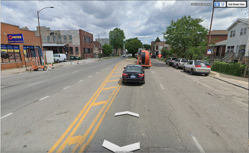
In contrast, Ashland Avenue's five lane thoroughfare (center left-turn lane intermittent with green medians) (with two active lanes of traffic on each side) has a much higher capacity, characterizing it as an avenue. I would say the same is true for Pershing, Archer, and Damen, and that the only thoroughfare which reaches true boulevard status is Western.
In addition to a substantial center median separating directions of traffic and higher capacity (3 lanes each side), Western enjoys adjacent slip roads enabling parking access for residents off of the major thoroughfare, which would characterize it as a boulevard. And of course, there also exists in McKinley Park various smaller paths (especially in the namesake Park) and alleys below the capacity and speed of an ordinary street.
McKinley Park is an extraordinarily well-connected neighborhood, due in large part to the uniformity of its grid pattern (Savannah pattern) and the seven major thoroughfares (ranging in capacity/speed from larger streets to boulevards and even one expressway) enabling both intra- and inter-neighborhood access. Elongated blocks de-emphasize and separate quieter residential streets (ex: Winchester, Wolcott) and emphasize quadrant-delineating major thoroughfares. This particular variety of network type, block type, and thoroughfare type combine to produce a highly permeable neighborhood for both pedestrians and vehicular traffic.
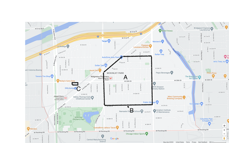
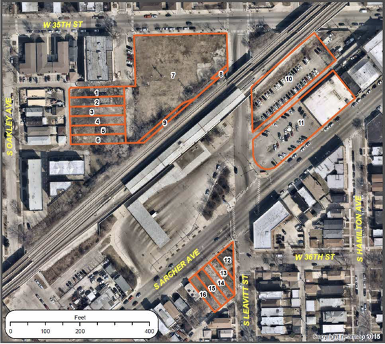
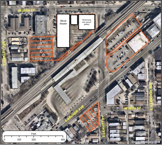
My overarching objective is to promote equitable, pedestrian-oriented mixed-use development in McKinley Park in order to improve the servicing of the neighborhood and surrounding region. My three targeted interventions are as follows: A) upzone the pentagon between Damen/Archer/33rd St/Ashland from its current RS-3 (single-unit family dwellings), likely to RT-4 (residential two-flat, townhouse, and multi-unit district) in order to support the neighborhood plan’s desire for a pedestrian corridor along 35th St. B) Cover the southeastern gap in the combined grocery pedestrian shed by converting the vacant building at 3702 S. Wood St into a local, pedestrian-oriented grocery store. C) Build an arts hub on the large vacant lot to the immediate north of the 35th/Archer Orange Line stop. This hub would include an independent movie theater (southwest Chicago’s first) and a performing arts venue/small art gallery, separated by a ground-floor full-service restaurant with residential units on top.
Fig. 1 Proposed interventions A, B, and C. Basemap: Google Maps
These interventions are motivated by the theories of Jane Jacobs and the emphasis on the human scale that underpins the 15 minute city movement. Jacobs argued that cities needed an intricate, close-grained diversity of uses that would provide constant mutual support to one another. “Constant mutual support” involves mixed primary uses that draw people towards an area at different times throughout the day such that pedestrian activity is perpetually present—even during traditionally slow or dead periods—and each primary use receives more visitors than it alone would draw. She argued against the “sorting and sifting out of particular land uses,” particularly the “decontamination” achieved by relegating cultural and civic centers to art enclaves separated from the “workaday” city (Jacobs 1961). The 15-minute city is a movement that builds upon the familiar quarter-mile “pedestrian shed” (wherein all daily life needs can be met within a five minute walk) such that all human needs and many wants can be met within 15 minutes of travel; while open to interpretation, it fundamentally seeks to design cities for the human scale (not the automobile) (Steuteville 2021).
City planning departments (CMAP and DPD) collaborated with the McKinley Park Development Council (MPDC) and neighborhood residents and stakeholders in 2021 to produce the McKinley Park Neighborhood Plan, the neighborhood’s first ever formal plan. The collaborators identified six guiding principles, of which the first two were 1) to preserve neighborhood diversity, especially through the preservation of affordable housing, and 2) to promote equitable transit-oriented development. They also expressed an interest in further developing a pedestrian corridor along 35th St from Hoyne to Ashland while citing concerns over current commercial vacancy and turnover rates (McKinley Park Development Council et al 2021).
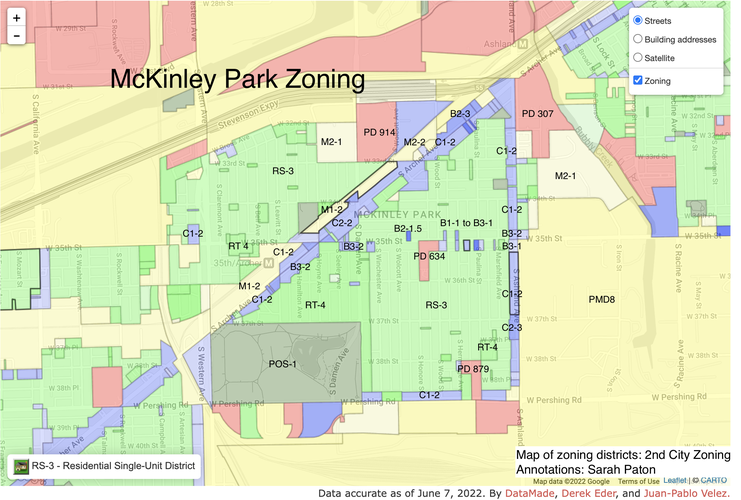
Existing zoning regulations insisting upon large swathes of single-use land, particularly those designated as single-family residential (RS-3: residential single-unit district, detached single family homes and two flats) do a disservice to the community as they inhibit the close-grained diversity of uses necessary to ensure consistent pedestrian activity.
Fig. 2. McKinley Park's current zoning regulations. Basemap: Second City Zoning & Google Maps
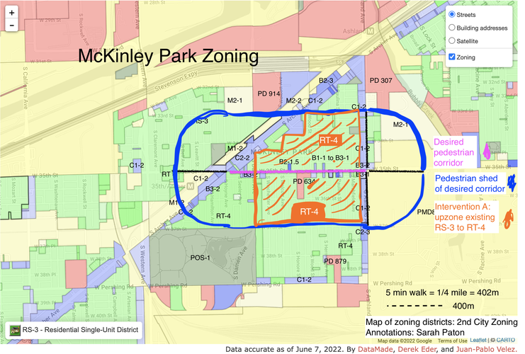
Intervention A would upzone a portion of current single-family residential land within a 5-minute pedestrian shed of the desired 35th St corridor to at least an RT-4 designation (residential two-flat, townhouse, and multi-unit district). This change would enable gradual redevelopment and a population increase within the pedestrian shed of the desired 35th St corridor. This increase in residential pedestrian activity would support existing commercial pedestrian activity, ideally so much so that current turnover/vacancy rates decrease.
Fig. 3. Intervention A. Basemap: Second City Zoning & Google Maps
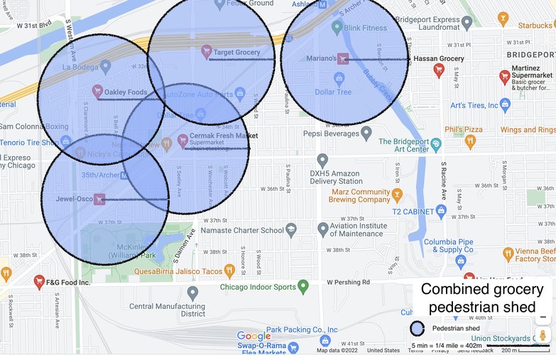
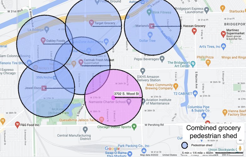
I assessed the pedestrian shed of two daily life needs in the Amenities section. The combined grocery pedestrian shed is recreated below.
Fig. 4. The existing combined grocery pedestrian shed for McKinley Park. Basemap: Google Maps
The five grocery stores in McKinley Park are Jewel Osco, Oakley Foods, Target, Mariano’s, and Cermak Fresh Market. Of these five, both Mariano’s and Target are extremely car-oriented and set back from the street by expansive parking lots. Jewel Osco is moderately car-oriented, as it is set back by a medium parking lot and positioned on busy arterial Archer Avenue. Cermak Market is at the center of a busy vehicular intersection, but it is fairly accessible to pedestrians. Oakley Foods is pedestrian oriented and the neighborhood’s only independent grocery store. As depicted in the diagram above, their combined pedestrian shed covers the majority of residential McKinley Park with the exception of the southeast region. As existing grocery stores skew car-oriented and corporate, intervention B) would fill this gap in the combined grocery pedestrian shed with an independent, pedestrian-oriented grocery store.
Fig. 5. Intervention B's contribution to the combined grocery pedestrian shed. Basemap: Google Maps
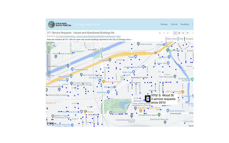
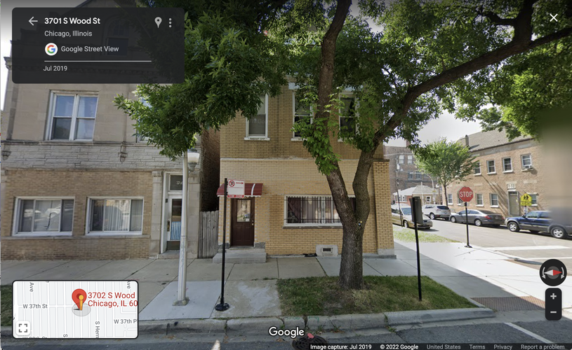
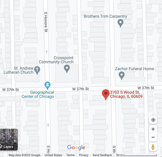
3702 S. Wood St is an ideal site for this intervention due to its prolonged vacancy and its proximity to other primary uses (two churches, a carpenter, and a funeral home). This mixing of primary uses would support consistent pedestrian activity along 37th St: churchgoers could pop by the grocery store after service and shoppers could chat with clergy and check out community offerings between errands.
Fig. 6. A map of 311 service requests for vacant buildings in McKinley Park shows that 3702 S. Wood St has been repeatedly reported vacant. Map: Chicago Open Data Portal
Fig. 7. 3702 S. Wood St. Image: Google Street View
Fig. 8. Neighboring establishments to 3702 S. Wood St include two churches, a carpenter, and a funeral home. Image: Google Mapss
The McKinley Park Neighborhood Plan expresses a desire to attract transit-oriented development to the neighborhood. It identifies the large vacant lot at the corner of 35th St. and S. Leavitt St. as a potential site for such development due to it being adjacent to the 35th/Archer Orange Line CTA station. A movie theater is a primary use that would draw people from across the southwest Chicago region via transit, as it would be the neighborhood and the region’s first. McKinley Park also lacks any community performance venue or art galleries. The vacant lot is sufficiently large to hold multiple storefronts, and the combination of these two primary uses with a supporting ground-level restaurant (with residences on top) so close to transit could potentially bolster secondary diversity in the area and draw people into the neighborhood.
Fig. 9. Vacant lots near the 35th/Archer Orange Line CTA stop.
Fig 10. Proposed intervention C
Social Mix
Per the Simpson Diversity Index, McKinley Park is less diverse than Chicago for the variables of race/ethnicity, educational attainment for population 25yrs+, and housing structure. The Simpson index provides a sense of how evenly distributed a population is into n categories for a given variable; in order to (hopefully) get a more meaningful sense of value distribution, I combined categories which seemed to be outliers, e.g. for race/ethnicity I went from 14 to 5 (Non-Hispanic White, Non-Hispanic Black, Non-Hispanic Asian, Non-Hispanic Others, and Hispanic) and for housing structure I went from 10 to 5 (1 unit, 2, 3-4, 5+, and non-unit/other). With a diversity index of about 2.55 and 5 total categories, race/ethnicity in McKinley Park is roughly halfway between being evenly distributed (5) and being entirely concentrated in one category (1); this makes sense, as McKinley park both has a single majority race/ethnicity (just—at about 53% Hispanic) and significant portions of non-majority ethnicities (about 15% non-Hispanic White and 30% non-Hispanic Asian). I would say this makes it fairly ethnically/racially diverse.
Educational attainment and housing structure are likewise neither entirely concentrated in one category (1) nor fully evenly distributed (n: 7 and 5 respectively);, these two measures have values just in the upper half of their indices, making them roughly more evenly spread than there are concentrated. Neither variable has a category with a simple majority for McKinley Park. While McKinley Park is therefore not predominantly single-family housing, housing type does tend toward lower units per building: 43% of buildings were single unit, and the next highest categories were 2-unit (36.9%) and 3-4 unit (13.2%)–buildings with higher occupancy (5+) accounted for less than 7% of buildings in the neighborhood. The spread of values for educational attainment surprised me: no one category claimed 1/3 or more of the population. The largest category was high-school/equivalency with almost 30%, but less than high school, bachelor’s and some college all had values in the range of 15-25% (all post-grad constituted about 10% of the population). There is no one standard for educational attainment in McKinley Park—while there’s a significant portion of the population that drops out, there’s also a significant portion that pursues post-grad opportunities. I’ve never lived in a neighborhood where educational attainment is this evenly spread, so this surprised me.
All demographic measures originate from ACS 2020 5-year estimates, data I accessed via Social Explorer.