Overview
Social Mix
Public Space
Amenities
Connections
Final Project
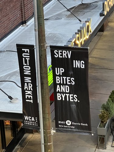
This catchy slogan is flaunted on dozens of street-light banners across Fulton Market and is truly testament to the neighborhood's up-and-coming identity. As with any trending neighborhood, population is an ever-changing metric that is difficult to measure. According to 2020 Census Data, the population of Fulton Market is estimated to be 4,476 people, fitting quite snugly within the "small high school" neighborhood definition. This figure was found by taking half of the population of Census Tract 8330 (as Fulton Market takes up almost exactly half of this Tract) and 13% of Census Tract 2801's population (found by taking measurements of Fulton Market's area compared to the Tract's area as a whole on Google Earth Pro). While this number may appear small for an area so close to Chicago's Loop, it has exploded from its prior population of 2,016 in 2010. This is evidence of the ongoing, explosive growth it has experienced in recent years.
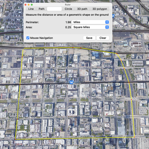
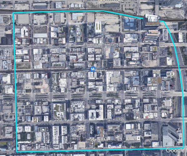
Whatever Fulton Market lacks in raw numbers, it definitely makes up for with density. The above image from Google Earth Pro shows the neighborhood to have an area of 0.25 square miles and a nearly 2 mile long perimeter. With these numbers, the density of Fulton Market is a whopping 17,904 people per square mile. This is 1.48x larger than the city of Chicago's average and 13.58x larger than Chicagoland's average!
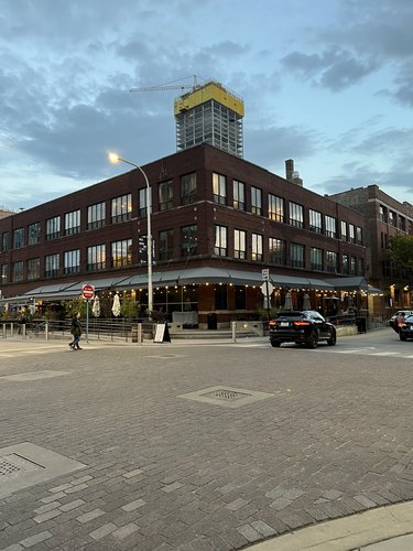
Bars, bistros, and bitcoin boys are the three Bs of Fulton Market. Passers-by can often be heard gossiping about the latest and greatest of each as they bustle around the CTA Morgan Station. These three things have become key pillars of Fulton Market's identity in recent years. Here, once abandoned warehouses and industrial sites have been repurposed into upscale restaurants, sports bars, and bleeding edge tech startup offices. While some residents and signage still clings to the identity of the larger West Loop, the voices of opposition are growing louder and louder every day to create a new, cohesive voice for Fulton Market. This push has been backed by the city of Chicago through the area's designation as a historic district in 2015 aimed at preserving its historic character as a former center for meatpacking and food distribution. Fulton Market's sense of identity grows even stronger with the clear boundaries surrounding it, with the Kennedy Expressway (I-90/94) carving through the East side of the neighborhood and Metra/Amtrak tracks bounding the North side. The South boundary of the neighborhood is defined by a noticeable lack of historic character south of Madison Street, with a shift toward modern construction over renovated warehouses. Where things get complicated is the Western boundary. Having been on the ground in this neighborhood, it is easily seen that Racine Avenue is the border between two completely different worlds. Apple Maps classifies both sides of this street (as well as several blocks West) as "Fulton Market." However, the difference in land use, and culture, and general feel is so starkly different on each side that they cannot in good conscience be labeled as the same. On the East side of Racine, there is the New Fulton Market: ever-changing, thriving, walkable, and inviting. On the West side is the Old Fulton Market that is much more in touch with the greater area's history in meatpacking, as evidenced by the wide roads, uninviting buildings, and butcher shops. For this reason, the Western boundary of today's Fulton Market is Racine Avenue.
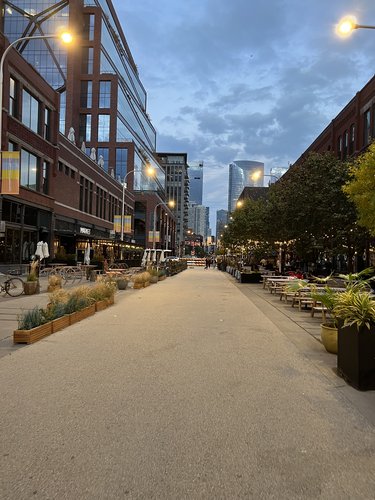
Cobblestone streets are dotted across Fulton Market as a both a testament to its historic character and a force to calm traffic on the newly pedestrianized Fulton Market Street. This pedestrianization has led to the intermingling between residents and tourists through the vast use of outdoor dining areas. Some establishments have fully embraced this outdoor space and have designated areas for patrons to play backyard barbeque games such as cornhole on the former sidewalk.
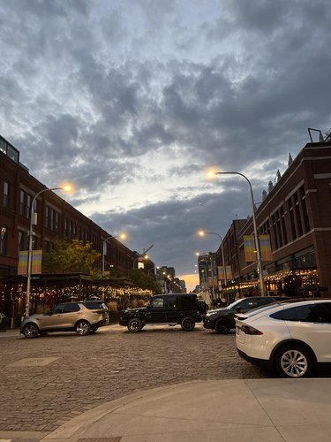
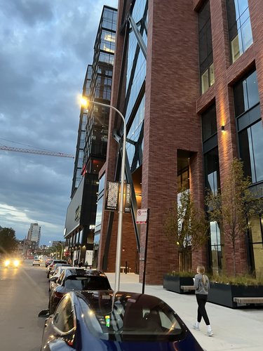
An excellent way to determine a neighborhood's socio-economic identity is to observe the types of cars parked and driving on the streets. Fulton Market is no exception to this rule. The images above show samples of the shiny, new cars that tend to be driven by wealthy, college educated people. This is a well known fact of Fulton Market given the large population of highly-paid tech workers and the well-off clientele of the neighborhood's upscale restaurants. The streets of Fulton Market are certainly not strangers to Teslas, Acuras, and BMWs.
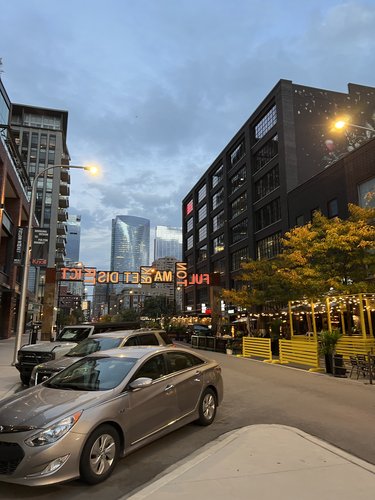
A large contributor to Fulton Market's sense of identity is the constant presence of signs to alert visitors and remind residents of the neighbhorhood they're in.
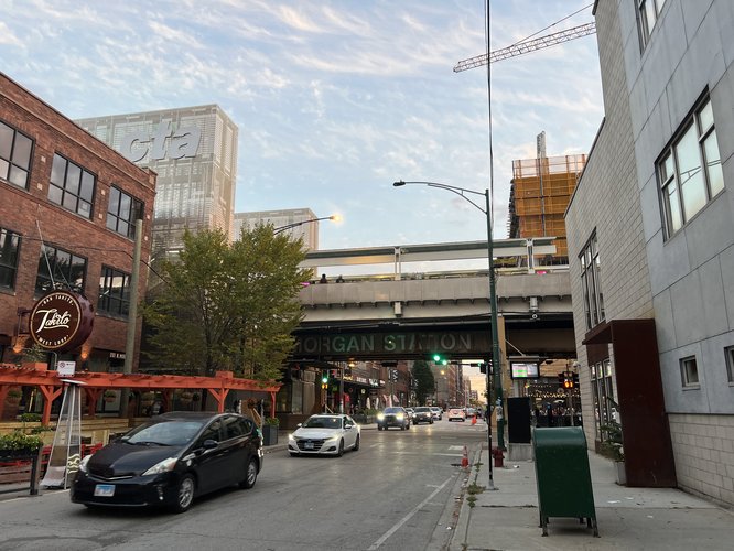
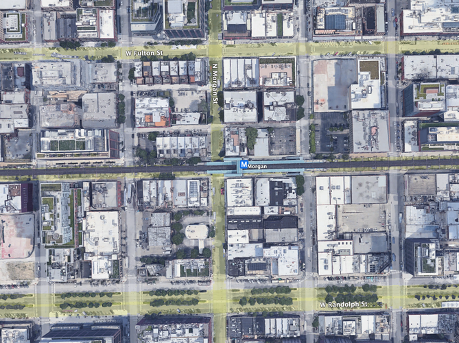
While many may believe that the pedestrianized Fulton Market Street or the wide and busy Randolph Street may be the centers of Fulton Market, the actual community center in practice is the Morgan CTA Station. Serving 2 'L' lines (Green and Pink), this newly renovated station is at the geographical center of the neighborhood and sees countless people moving through it daily. Its doors are used as a meeting place for friends, families, and commuters and is often the site of loud and happy hugs and other greetings.
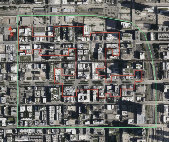
Shown above is the complex layout of the Fulton-Randolph Market Historic District (outlined in red) designated by the City of Chicago in 2015 in comparison to the broader boundaries of the Fulton Market neighborhood (outlined in green).
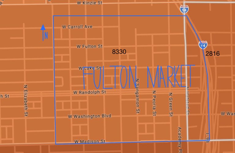
Shown above are the two Census Tracts that make up Fulton Market (outlined in blue). Most of the neighborhood is located in Tract 8330 (outlined by a dull white line South of Kinzie Street and North of Madison Street). A small portion of the neighborhood is also located in Tract 2816 (outlined with a bright white line).
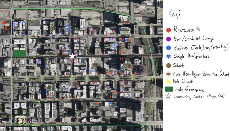
The history of Fulton Market is that of booming business, urban decay, and phoenix-like rebirth.
It first came into the world as the center of meatpacking and distribution for the city of Chicago. In the past, meatpacking was one of Chicago's most important industries and Fulton Market worked in tandem with other meatpacking neighborhoods such as the Union Stock Yards on the South Side. Districts like Fulton Market were the reason Chicago was dubbed by historians as "The Great Central Market" and "The Golden Funnel" for all the agricultural products that flowed through the city. The insane logistics and manpower that allowed food to get from the countryside to urban consumers defined the purpose of this neighborhood, even warranting the construction of a commuter rail terminal a short walk away on Clinton Avenue. Gustavus Swift, Philip Armour, and Nelson Morris were all famous meat packers that had branch offices in Fulton Market in the early 1900s and the hollow shells of their warehouses are a rare sight for Chicago, but commonplace in Fulton Market.
This neighborhood's famous name came from the construction of a grand market hall in 1850 on Randolph Street. This building is still seen today, and is now repurposed to fit in with the neighborhood's famous "restaurant row." (Imaged below).
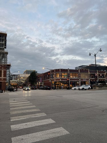
One of the biggest selling-points of Fulton Market as a neighborhood are the historic, antique buildings spread throughout. These gorgeous, brick buildings are all remnants of 19th and 20th century construction that ended in 1931 with the Richters Food Products Company on Randolph Street. In 2015, the City of Chicago passed a bill to codify Fulton Market as a historic district. This move followed increased interest in demolishing or irreversibly altering the neighborhood's dwindling supply of historic landmark buildings and was praised by preservationists across Chicagoland.
Meatpacking as an industry left Chicago in the 1970s to disperse across the hinterlands rather than staying concentrated in the city. Following the closures, meatpacking centers like Fulton Market were hotbeds of crime and were seen as dangerous by the general public. "Fulton Market and the West Loop only a couple decades ago was a place you'd avoid even during the day," said a tour guide passing under the Lake Street Bridge across the Chicago River while leading the Chicago Architectural Boat Tour. He echoes the not-so-distant memories that many Chicagoans have. However, as has been shown in the sections prior, Fulton Market has risen from its ashes to become a completely new entity. In a way, it is reviving itself into its old shoes as a center of commerce with the adoption of the tech industry as a replacement for meatpacking. Perhaps this is the new future industry for Chicago as a whole, and districts like Fulton Market are going to be the first to take up the torch.
Gorski, Eleanor. "Fulton-Randolph Market District (cont.)," City of Chicago Department of Planning and Development, n.d. https://www.chicago.gov/city/en/depts/dcd/supp_info/Fulton_Randolph_Market_Hist_Dist_2.html.
"Landmark Designation Report: Fulton-Randolph Market District," City of Chicago Department of Planning and Development, 13 May 2015, https://www.chicago.gov/content/dam/city/depts/zlup/Historic_Preservation/Publications/Final_Designation_Report.pdf.
LaTrace, AJ. "What the New Fulton-Randolph Landmark District Means for the West Loop," Curbed Chicago, 31 July 2015, https://chicago.curbed.com/2015/7/31/9935234/fulton-market-landmark-district.
Van Loon, Benjamin. "Fulton-Randolph Historic District Receives Landmark Approval," Curbed Chicago, 14 May 2015, https://chicago.curbed.com/2015/5/14/9961172/fultonrandolph-historic-district-receives-landmark-approval.
Elejalde-Ruiz, Alexia. "City Council Gives Final OK to Landmark Fulton Market District," Chicago Tribute, 29 July 2015, https://www.chicagotribune.com/business/ct-fulton-landmarking-0730-biz-20150729-story.html.
Each, Molly. "Chicago Tech Neighborhood Guide: Fulton Market Challenges River North's Startup Supremacy," Built in Chicago, 12 May 2017, https://www.builtinchicago.org/2017/05/09/chicago-tech-neighborhood-guide-fulton-market-challenges-river-north-s-startup-supremacy.
www.socialexplorer.org
Fulton Market is not your average neighborhood, particularly when it comes to public spaces. While many neighborhoods have a more traditional approach for public space (dog parks, playgrounds, and plazas), Fulton Market defies all of these standards with its emphasis on food halls and bars. This emphasis is so heavy that there are very few other options (especially safe and accessible ones) for the neighborhood's residents to enjoy. Based on several reconnaissance visits to the neighborhood, its public spaces can be divided into three distinct categories: 21+, Under 21, and "Underground."
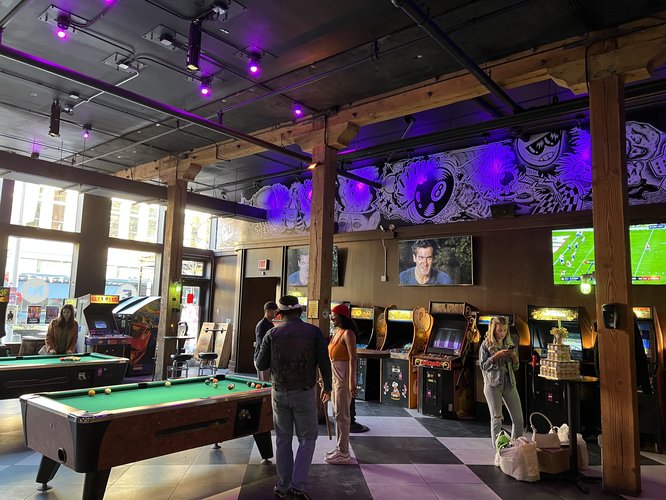
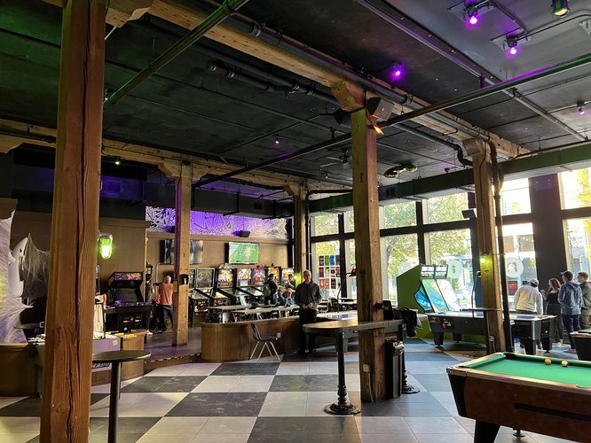
It has been established in previous sections that Fulton Market is a place primarily catering to the office worker, tourist, and upper-middle class Chicagoan. The catering to these demographics is never more clear than when looking at public space. Bars and upscale restaurants dot the landscape and have become congregation places for the majority of the neighborhood's residents. Pictured below is one such example: Emporium Arcade and Bar.
[Indoor views of Emporium Arcade and Bar - Fulton Market 10-30-22]
The Emporium Arcade and Bar is the shining example of public space in Fulton Market. It markets itself as a place where adults (over 21 years old) can gather, socialize, drink, and play both video games and pool while listening to music. In a brief interview with some employees, they described the space as a space "open to everyone" with DJs and other events drawing people from around the city. They also mentioned that public spaces like this one are packed just before people eat dinner and then again from 10 pm until they close at 2 am. The crowds that use these spaces come from very diverse backgrounds, but whether they be tourists, suburbanites, Chicagoans, or Fulton Market residents, everyone can be found crowded around PacMan or taking turns at a game of pool.
[Outside view of Federales Bar on Morgan and Lake 10-30-22]
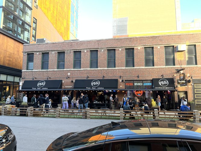
[Outside view of PB&J Pizza, Beer, Jukebox 10-30-22]
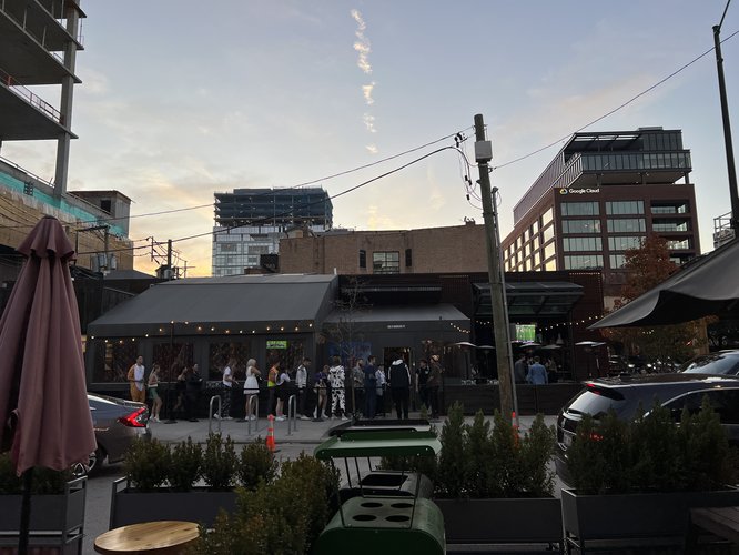
Pictured above is a particularly interesting phenomenon in Fulton Market, as these pictures were taken on October 30th, the day before Halloween. At this time, commonly known as "Halloweekend," many Chicagoans and tourists alike flock to neighborhoods like Fulton Market due to their prominent bar scenes. In the first image, a line of patrons to a sports bar on Morgan can be seen forming at as early as 4:30 pm! Indoor/outdoor bars which have a blurred line between indoor and outdoor dining are a staple in the neighborhood and often boast long wait times as the sun goes down. In a neighborhood that lacks traditional green space and public plazas, there is not much other choice close to home for residents. However, these exciting examples are only scratching the surface of Fulton Market's identity as a night-life destination.
As Jane Jacobs so commonly says, it is important for a neighborhood to have a multitude of uses for people at all times of the day. In a neighborhood like Fulton Market which is mainly geared toward 21+ people craving pricy beer and dancing, this dichotomy between daytime use and night life is far from ignored. Taking a break from the many bars of this neighborhood, we move on to the (almost as) famous food scene.
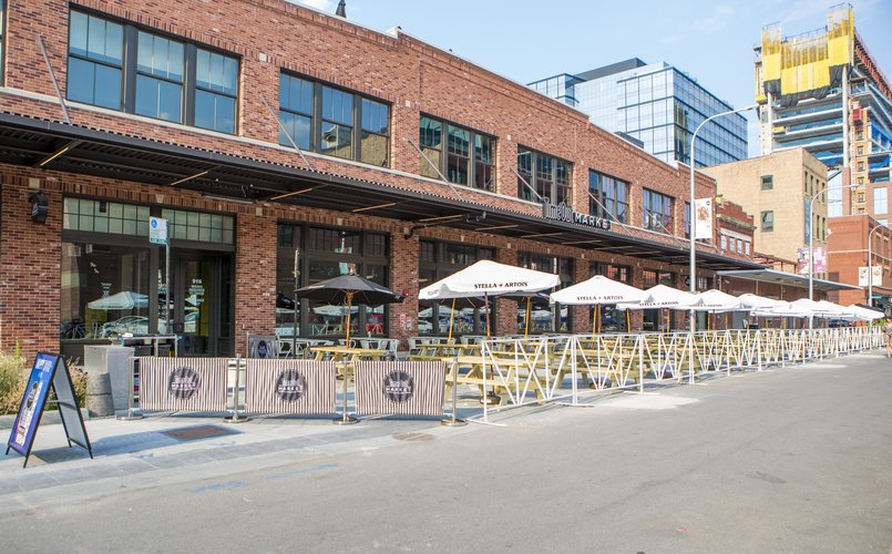
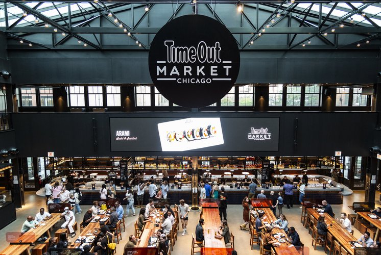
[Outside view of Timeout Market Chicago taken from timeout.com]
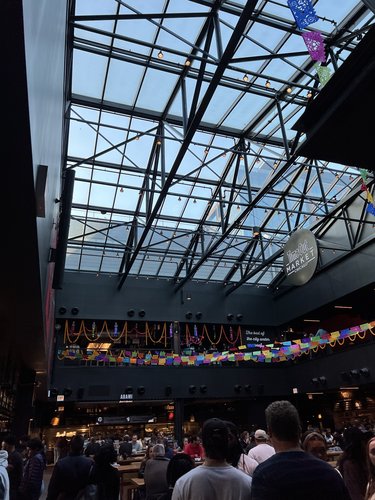
[Ground view of Timeout Market 10-30-22]
[2nd Floor View of Timeout Market Chicago taken from timeout.com]
It is very fitting that the "up-and-coming" neighborhood of Fulton Market partakes in and perfects the trendiest of all restaurant concepts: the food hall. Many food halls have sprung up around the city, and Fulton Market has truly embraced the opportunities for public space that they provide. Timeout Market Chicago is a name many Chicagoans have heard of before, and that popularity is very accurately reflected by the various merchants' long lines and crowded tables. Upon interviewing some workers at the vendors inside, many expressed their delight at the crowds present. One worker said that food halls like Timeout Market are one of the only places where people under 21 can congregate. He expressed that most of Fulton Market is void of traditional public space, and with most of the neighborhood being dominated by bars, Timeout Market is one of the few age-egalitarian and family friendly places left to gather. The crowds present at this establishment absolutely reflected this sentiment, with people of all ages (and especially families with young kids) crowding the long tables in the main hall and the outdoor seating on the pedestrianized street.
Fulton Market seems especially fit for these types of enterprises due to its history as a warehouse district. This all-brick building where Timeout Market now resides is testament to the spacious layouts many buildings in the neighborhood still have retained. This is in part thanks to the incredible efforts of preservationists and the city's relatively recent landmark designation of the area. With all of this space inside, it is almost as if the outdoor, traditional public space is not missed.
Upon speaking to the employees of various Fulton Market establishments, some have come forward to offer a more unorthodox take on Fulton Market's public space. Despite the neighborhood's massive population growth and economic development, Fulton Market used to be a sparsely occupied, nearly abandoned warehouse district. As such, there were a lot of abandoned buildings and empty lots, particularly along the neighborhood's Northern boundary. With many eyes diverted away from the neighborhood, new opportunities for local artists opened up. The abundance of empty buildings was not interpreted as a blight, but instead a blank canvass, and from there the art scene arose.
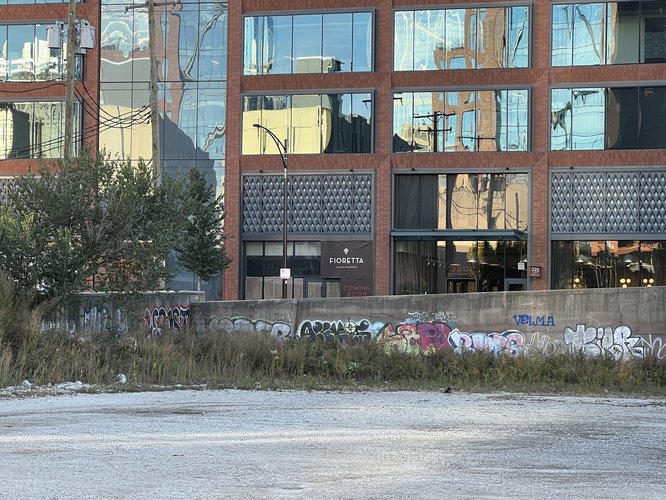
[Distant wall art / graffiti on Green Street 10-30-22]
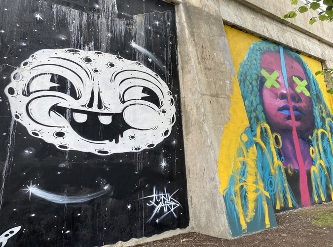
[Hubbard Street Mural Photographs taken from the blog "Hubbard Street Murals: Chicago's Street Art Gallery"]
[Juice WRLD Memorial taken from the Chicago Sun Times]
While Fulton Market's official Northern boundary is the shared Amtrak / Metra rail corridor on West Carroll Avenue, many neighborhood workers (especially the ones interviewed above) have declared that more of a "soft boundary" and state that the line is often blurred to include the Union Pacific West Line Metra tracks at West Hubbard Street. The viaduct used for this rail right-of-way contains the "Hubbard Street Murals," which was a project began in the 1970's by Chicago Art Institute students. There are countless works of beautiful street art on display for the public along this stretch of Hubbard Street. Many workers in the neighborhood say that they enjoy taking their breaks walking along the viaduct and viewing the murals.
One worker who also identifies as a local artist pivots away from this more popular attraction and describes the southern Amtrak / Metra tracks as the place to be for the neighborhood's "underground" artists. There were several stories told of walking along the tracks, dodging trains, and practicing artwork on any available space, but unfortunately much of it is out of reach to the general public. While the Carroll Avenue artwork is inaccessible, there are many examples of street artwork spread throughout the neighborhood in parking lots, back alleys, and construction sites that showcase the neighborhood's "underground" identity carried over from its days as an industrial district.
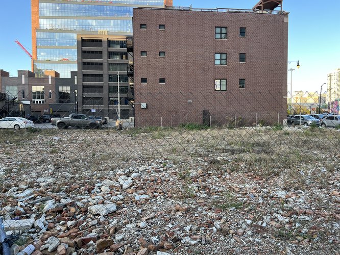
While not always completely obvious, Fulton Market has a lot to offer in terms of public space. As shown above, food halls and bars dominate the vast majority of the landscape, with almost no options for traditional public spaces common in other neighborhoods. One major concern that arises with Fulton Market's dependence on bars and restaurants as gathering places is the accessibility to those of lower incomes. While many people in the neighborhood have commented on its ability to draw crowds from across the city and abroad as well as its accessibility to everyone, the majority of the neighborhood's public space is, unfortunately, locked behind a pay wall. Bars, for example, are not places where people can go to congregate and exist without the expectation of paying for a drink. Similarly, food halls are spaces that expect visitors to buy a meal. Generally, this is to be expected from private businesses, especially those that were built to serve the dining crowd. However, when a cheeseburger can cost upwards of $17 and a cocktail around the same, the vast majority of people are priced out of the neighborhood. That leaves lower income people with the following options for public space imaged below:
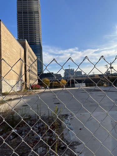
[Rubble-filled lot in Fulton Market 10-30-22]
[Fenced off empty lot in Fulton Market 10-30-22]
While it isn't pretty, these fenced off and neglected lots are the only spaces the residents of Fulton Market have where they aren't expected to break the bank. Naturally, this creates a hostile environment that is completely inaccessible to the vast majority of people, especially those of lower income. This lack of free public space is definitely a factor in the neighborhood's lack of diversity among residents and, unless something is done to rectify this, it will continue to drive those of lower incomes away. Although, even having said that, the famous phrase "life finds a way" rings true in Fulton Market. Those who can afford it stick to the bars and food halls, while those who can't hop the fences, shake their spray-paint cans, and express their art.
Fulton Market is known for its food, nightlife, and corporate presence, but how does it fair in terms of amenities and providing for the everyday needs of its residents? In this section, the neighborhood's coverage of grocery stores and schools will be analyzed.
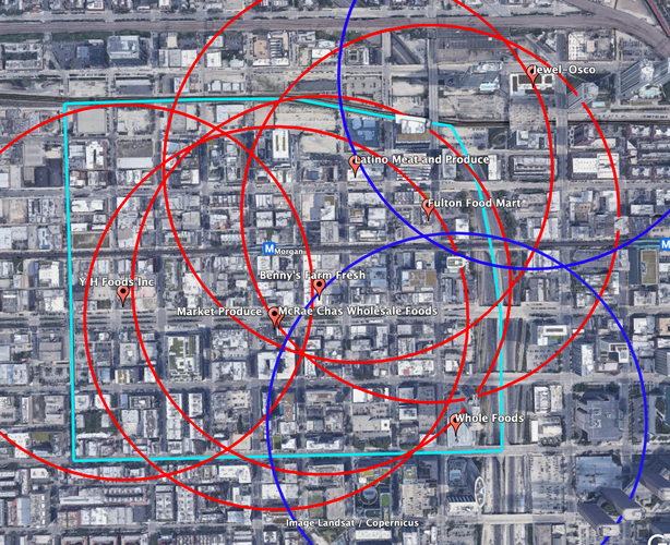
The image above shows the coverage of grocery stores across Fulton Market (outlined in light blue). Red pins point out the locations of both big-box grocery stores, smaller specialty grocers, and locally owned food markets. The red circles are the 5-minute walksheds surrounding each of the two latter options, with the blue circles representing 5-minute walksheds for big-box grocers. Fulton Market at first glance appears to be doing well in terms of grocery store coverage, with nearly all of the neighborhood's residents being within a 5-minute walk of some form of grocer. However, many of these stores are very pricy or only offer a limited selection of produce/products for residents to choose from. This is why I chose to differentiate between these smaller stores and the big-box grocers in and around the neighborhood (Whole Foods and Jewel-Osco) that offer a much wider range of options. Despite having more options and being generally more inexpensive, big-box grocers only cover 36% of Fulton Market with their 5-minute walksheds.
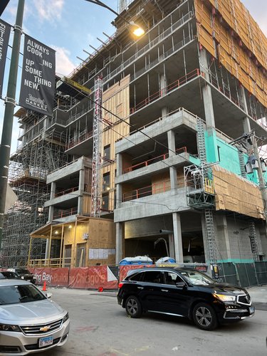
In terms of walkability and safety, most of these stores have safe, walkable paths to allow residents to access them freely. However, in recent years navigation of Fulton Market's gridded streets has been interrupted by large construction projects. Several visitors to the neighborhood expressed concerns surrounding these projects, with one couple walking their dog saying that the broken glass and construction trash poses a risk for their safety. Another factor to note is that the Jewel-Osco is located across the Kennedy Expressway, making the walk for those who choose to shop there very unpleasant due to the bridges' lack of basic pedestrian safety and accessibility infrastructure.
[A construction project that has closed the sidewalk on Morgan Street]
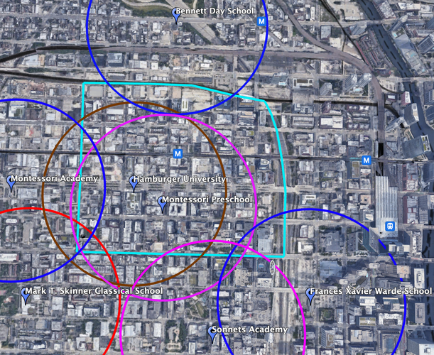
The school presence in Fulton Market paints a completely different picture of coverage than the grocery stores. All schools in the above image are marked with blue pins. To begin, there are no high schools whose 5-minute walksheds cross the neighborhood's boundaries. The closest one is a magnet school that is nearly 10 minutes away by walking from the neighborhood's edge. Following this trend, elementary schools are also in short supply. Private elementary schools (with blue walksheds) are all located outside of the neighborhood's boundaries and only provide coverage to 20% of the neighborhood. There is only 1 CPS public elementary school whose walkshed (in red) crosses the boundaries, and it leaves Fulton Market with only a 1.4% coverage. Where the neighborhood does see a lot of coverage, however, is pre-schooling, with 64% of the neighborhood being within a 5 minute walk (shown in pink). Additionally, higher education has one notable presence in the neighborhood with a coverage (shown in brown) of 60% due to Hamburger University owning a building on Randolph Street.
In terms of walkability and safety, there does appear to be a benefit to having elementary schools located outside of Fulton Market's borders. While it may be challenging for children to walk within these borders due to the aforementioned heavy construction, once they leave they can typically find calmer and cleaner streets to walk on. However, the distances will be quite far for many people living toward the neighborhood's center and also pose accessibility challenges for those with low mobility. This safety factor does not hold, though, for preschool and college students who attend school inside the neighborhood and must still deal with closed sidewalks and construction. There are also exceptions for Francis Xavier Warde and Bennett Day elementary schools, who are both located across very hard boundaries with the former being the Kennedy Expressway and the latter being two sets of Metra tracks.
Both on the ground and on the map, the evidence shows that Fulton Market is severely lacking in amenities that provide for its residents everyday needs. With the vast majority of residents forced to buy food at small, specialty stores and with very few or even no options for education (particularly affordable public education), the neighborhood has a long way to go before it can effectively meet the needs of its growing population. These factors are no doubt key in the homogeneity of Fulton Market both in terms of income and the lack of families. The claim that Fulton Market is built for the middle-aged, college educated, door-dash ordering, childless professional is backed by the neighborhood's lack of grocery stores and schools.
[A birds-eye view of the blocks in Fulton Market]
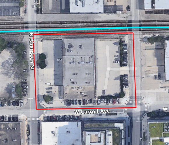
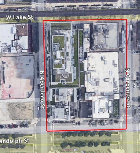
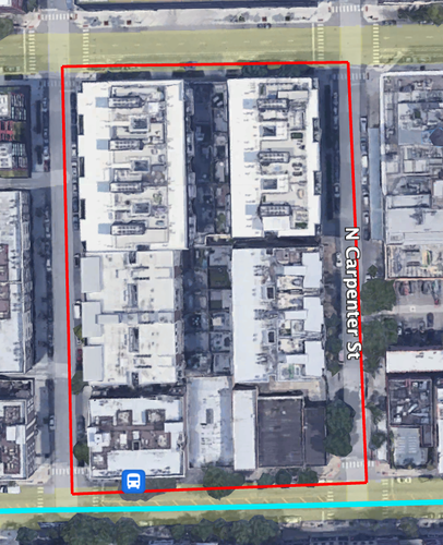
The types of blocks used in Fulton Market vary slightly as one moves from north to south. While all of them are considered "Elongated Blocks" under the Lexicon of the New Urbanism, the northernmost blocks between Lake Street and the Metra tracks more closely resemble "Square Blocks," measuring at roughly 300 ft x 260 ft. South of Lake Street, the blocks begin to elongate, measuring in at roughly 270 ft x 370 ft. Then, they reach their longest south of Washington Boulevard at 285 ft x 450 ft. All of these examples are both narrower and shorter than the typical Chicago block which measures at 330 ft x 660 ft.
[Northernmost square-like block bounded by W Carroll Avenue and N Aberdeen Street]
[More elongated block south of W Lake Street bounded by W Randolph Street and N Aberdeen Street]
[Most elongated block south of W Washington Boulevard bounded by W Madison Street and N Aberdeen Street]
[Image of "Savanah" type network structure between W Fulton Market Street and W Randolph Street]
The network arrangement of Fulton Market almost perfectly resembles the "Savanah Pattern" outlined in the Lexicon of the New Urbanism. Although the blocks vary slightly in length and width, the near-perfect gridded streets are an obvious feature of the neighborhood when reviewing the image above. Fulton Market never defers from this pattern.
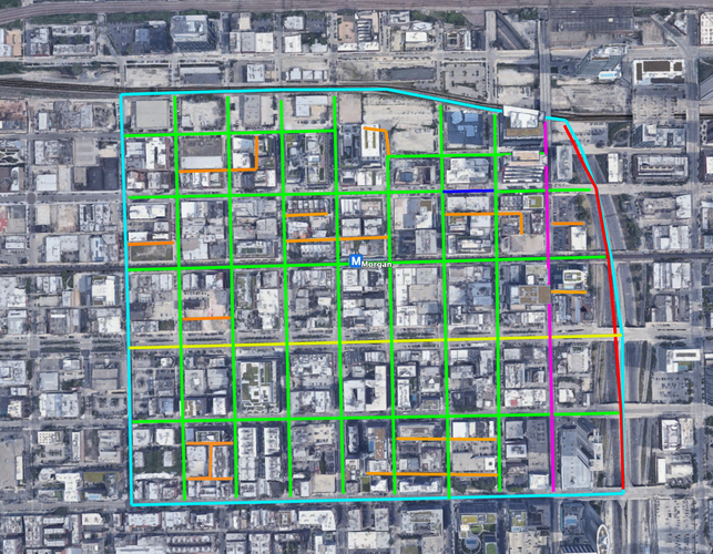
[A map of Fulton Market's thoroughfares]
[Key: Light Blue = Neighborhood Border, Red = Expressway, Green = Street, Yellow = Boulevard, Orange = Alley, Dark Blue = Passage, Pink = Avenue]
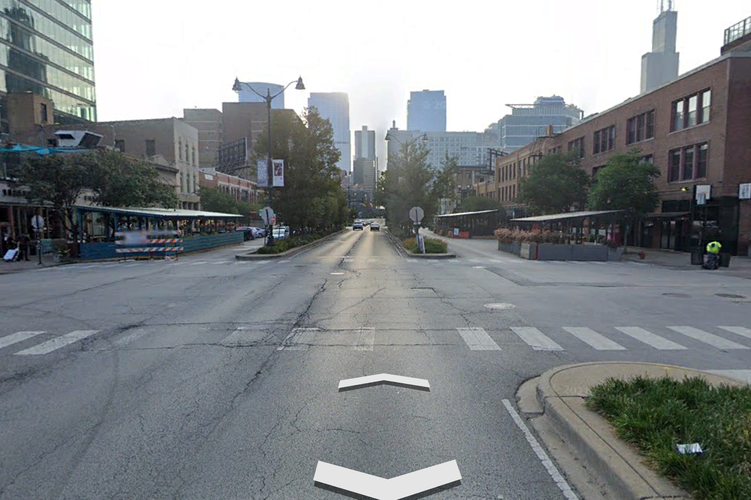
As can be seen with the map above, Fulton Market's thoroughfares largely consist of streets. The large Kennedy Expressway to the east marks the neighborhood's boundary. The neighborhood's only Avenue is Halsted, which is considered such due to its high-capacity design with wide lanes and center turning lanes to aid vehicle throughput. The main diversion from Fulton Market's street-only design is (unfitly named) W Randolph Street, which is classified as a boulevard. This thoroughfare is quite unique in that it has both local and express lanes separated by two medians (imaged below). The other unique feature is the closure of W Fulton Market Street between N Green Street and N Peoria Street to cars, instead creating a pedestrianized area best classified under the Lexicon of the New Urbanism as a "passage."
[Google Streetview image of W Randolph Street, displaying its clear design as a boulevard with express lanes for through traffic and local lanes for business access and parking]
When it comes to block type, Fulton Market is extremely well connected. Unlike most neighborhoods who are also made up of elongated blocks, Fulton Market's blocks are nearly square in the north and only slightly longer in the south. This leads to there being smaller distances between intersections, meaning that people traveling via all modes (particularly walking) have an easier time cutting through blocks that would normally be blocked under the typical 330 ft x 660 ft Chicago block. The one downside to the smaller block elongation is that parking is often very difficult to find in the neighborhood, which is a fact that many neighborhood residents resent, especially as more and more surface lots are being bought up and developed into mid-to-high-rises.
On the subject of network types, Fulton Market conforms exactly to the Savannah Pattern, with nearly perfectly straight roads in a grid pattern. The only small interruption of this grid is at the neighborhood's eastern boundary where the Kennedy Expressway plows its way from a perfectly northward alignment to a northwest alignment, giving the neighborhood a dog-ear type shape. Interestingly enough, the bridges that cross this sunken freeway continue the gridded pattern almost perfectly as if the expressway where never there. This reason is in part why there have been longstanding calls from neighborhood residents and city planners to place a cap over the expressway, linking Fulton Market with the West Loop Gate. Moving west from the freeway, the network type is strictly Savannah, albeit with no urban parks dotting the grid. While this setup is quite monotonous and robotic at face value, it does make navigating the neighborhood extremely easy with streets almost perfectly lining up with a compass rose. This promotes accessibility to both new and old residents.
Finally, when it comes to thoroughfare types, Fulton Market is again lacking in diversity. The vast majority of the neighborhood is criss-crossed with typical streets, providing low-speed, low capacity movement. While the low capacity of these streets are great for pedestrian connectivity via jaywalking and accident safety, the constant noise of backed up car traffic on W Lake Street and N Morgan Street is hectic for visitors and residents. This is, in part, due to the faulty design of the Kennedy Expressway, as it spits traffic out onto the low-capacity W Lake Street. On another note, some thoroughfares in the neighborhood are one-way, such as W Washington Boulevard (ironically designated a street). These one-way thoroughfares often have two lanes of one-way car traffic, but are still fairly low speed and capacity at the end of the day. The main interesting feature in Fulton Market's thoroughfare portfolio is W Randolph Street. W Randolph is considered a boulevard with its garden-separated local and express lanes. This setup incorporates landscaping and trees to separate through traffic from local traffic that accesses businesses and parking on the lower-speed, lower capacity outer carriage. While this provides benefits for drivers, it leaves pedestrians with quite the hectic crossing and detracts from the neighborhood's overall connectivity. In its current state, pedestrians have to cross the equivalent of 3 normal streets in 1 boulevard, oftentimes in intersections lacking traffic lights and walk signals.
Over all, Fulton Market is a well connected neighborhood on paper. It has nearly square blocks that allow for frequent crossovers, an easy to navigate Savannah pattern grid, and the vast majority of its thoroughfares are low-capacity, low-speed streets. While W Randolph Street provides some challenges for accessing the neighborhood's southern area due to its long crossing distance, the traffic along the thoroughfare remains slow and infrequent enough to be manageable at most times of the day. All of these factors allow for the neighborhood to be quite well connected, which is clear from the constant presence of joggers, dog-walkers, and tourists mingling about the crowded sidewalks.
Fulton Market is often said to have it all: food, fashion, high-paying jobs, and state-of-the art high rise housing, but it doesn't have much in terms of public space. Humans are social creatures and require spaces to congregate and, after exploring the neighborhood as it is today, there is a constant presence of pay-to-play spaces that aim to fill the neighborhood's void including bars and food halls. However, good social connection through interaction in public space requires a blending of all types of people at all hours of the day. These restaurants and food halls do not allow for this because not everyone can afford to spend money, especially if it is only to access a public space.
Now that it has been established that Fulton Market is severely lacking in free-to-use public space, the question presented is how to fix it. One cannot simply run a wrecking ball through historically protected buildings, and vacant land is extremely scarce in a neighborhood so close to Chicago's downtown. To solve this problem, Chicago must do what it did over a century ago upon the completion of the world's first skyscraper and build up.
Fulton Market 2.0 is a project that plans to revolutionize land use in Fulton Market through a stacked approach defined in three key interventions (outlined here as Phases 1 - 3).
"Make no little plans. They have no magic to stir men's blood and probably will not themselves be realized." - Daniel Burnham.
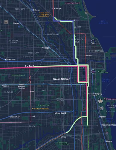
Phase 1 on Fulton Market 2.0, should it be completed, would go down in history as one of the most ambitious projects ever undertaken in Chicago's history and by far the most ambitious project in the 21st century, but in a city that raised the buildings in its downtown 4-14 feet over a century ago, this will be nothing in comparison. The key part of this phase of Fulton Market 2.0 is to burry the 'L' system across downtown Chicago to provide vast improvements to the CTA system. This phase will allow the neighborhood (and the city's downtown as a whole) to utilize the 'L' tracks for a new, elevated park system comparable to the High Line in Manhattan, New York. Figure 1 shows a detailed map of this project, including the construction of quad-tracked tunnels allowing for express services (pink), a new alignment of the eastern loop tracks onto the State Street Subway (also pink), a new brown/purple line alignment (purple), and a pedestrianized elevated park (light green). This elevated park (which will run along Lake Street in Fulton Market) is the key contribution of Phase 1 to improving Fulton Market's public space and will serve as the base requirement for the development of later phases.
[Figure 1: Hand-Drawn Map of "The Big Dig" (Map of Chicago from Apple Maps)]
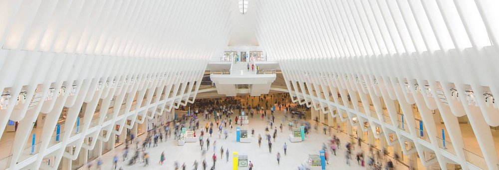
While this project will make city-wide waves, it is bound to revolutionize transit in Fulton Market especially. Increased connectivity through the addition of a new express line as well as the removal of loud noise from West Lake Street will bring more people onto the street to mingle in an enhanced public space. In addition, Figure 2 shows a photograph of the new community spaces that could be created from subterranean stations, which fits the theme of layering presented in this project (this example being from the Oculus in New York City which doubles as a subway station and mall).
[Figure 2: The Oculus Station and Mall in New York City, From officialworldtradecenter.com]
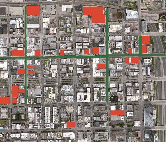
Phase 2 of Fulton Market 2.0 involves the transformation of the built environment to favor people over cars through the retrofitting of Morgan Station into a community center, the construction of dense housing over parking lots, and the pedestrianization of West Randolph Street. Figure 3 shows a map of this phase, which has surface-level parking lots highlighted in red as prime targets for affordable housing to be constructed, and the new elevated park highlighted in green along with its possible North/South extensions. The construction of this housing could also employ policies that give retail and restaurant workers who are employed in the neighborhood preferred status when applying for units in the new buildings, therefore increasing the diversity (both racial and economic) of the neighborhood as a domino effect.
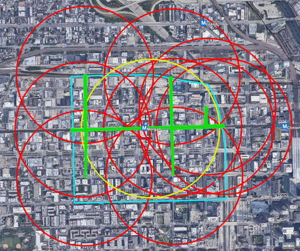
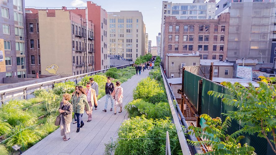
The goal of this construction project is to connect the neighborhood like never before through the grade separation of pedestrian traffic onto elevated green space, serving to promote safety and access to a third place. By moving most pedestrians to an elevated, well landscaped park, they no longer need to worry about crossing times, heavy car traffic, or dimly lit streets at night. This project would also allow for direct connections between buildings at the second or third floor, directly connecting residents of new housing to green, public space. With the construction of this elevated park, the entire neighborhood would be within a 5 minute walk (0.25 mile radius) of free-to-use green space (shown in Figure 4). With its use as a train station no longer needed, the CTA Green/Pink station at Morgan Street could be converted into a new community center as well. With the new, buried station located directly below it at the same intersection, visitors and residents will be deposited directly into the community's hub upon getting off the train. Uses of this space could range from art display, neighborhood history museums, meeting spaces, or anything in between. Figure 5 shows what this elevated park could look like using imagery from the High Line in New York.
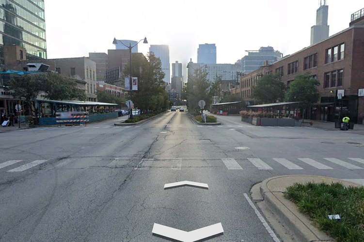
Additionally, this project would revitalize "Restaurant Row" on Randolph Street by removing perpendicular parking and the local traffic lanes, replacing them with wide sidewalks and restaurant kiosks as shown in Figure 6. Figure 6 is an image from a section of Randolph Street near Morgan Street where the old parking has already been converted to restaurant outdoor seating. Should this model be applied to the rest of this street within the neighborhood, the benefits of increased walkability, restaurant capacity, and, as Strong Towns found in one article, the 49 times higher profitability of this space in comparison to the parking originally there.
[Figure 3: A Hand-Drawn Map of Affordable Housing Construction and Elevated Park Retrofitting in Fulton Market]
[Figure 4: 5-Minute Pedestrian Walksheds (Red) for Elevated Green Space (Green) and Community Center (Gold) Created in Google Earth Pro]
[Figure 5: A Picture of the High Line in Manhattan, New York City, From timeout.com/newyork/parks/highline]
[Figure 6: A Screenshot from Google Earth Pro of the Intersection of Randolph Street and Morgan Street Showcasing the Replacement of Parking with Outdoor Dining].
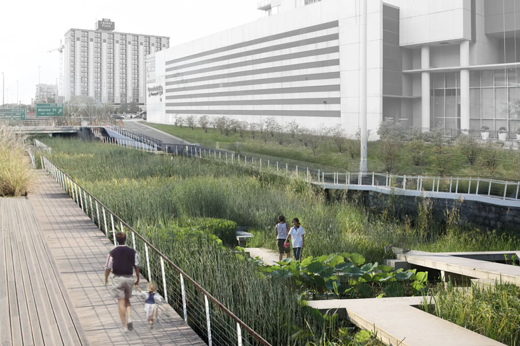
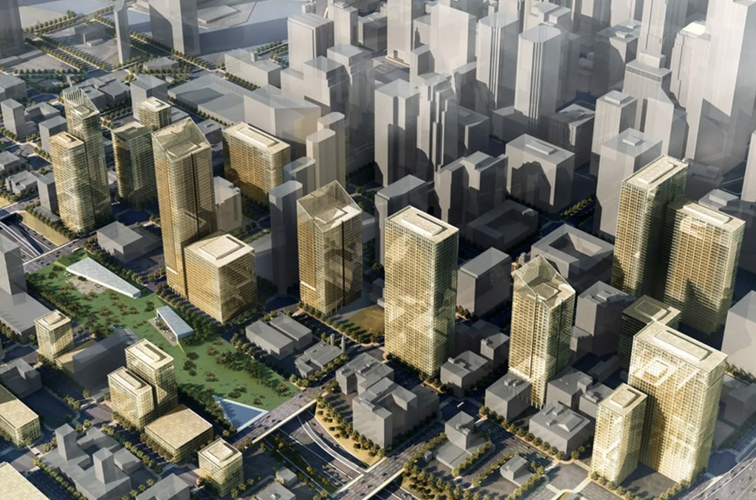
While the first two phases aim to revolutionize public space through large, newly imagined projects, the third and final phase of Fulton Market 2.0 aims to bring a more traditional approach into the mix. The idea of capping the Kennedy Expressway that carves through the West Loop has been on the minds of Chicagoans since its original proposal in a 2003 draft of the Central Area Plan. With freeway caps becoming relatively popular in their implementation in cities across the nation, Chicago is no doubt overdue in this respect. Capping the Kennedy would create some of the most valuable land in the city and reconnect the West Loop Gate and Fulton Market as it was a century ago. The new land could be used for any number of developments including housing and office space, but to truly best benefit the residents of Fulton Market, Phase 3 suggests the construction of a public park across the entirety of the cap. The completion of this project would bring an enormous park right to Fulton Market's doorstep, creating a space where residents can relax atop some of the only green, grassy areas in downtown west of Millennium Park. Figure 7 illustrates what this project could possibly look like for residents, should the Kennedy Cap be turned into a park / nature preserve. Figure 8 shows another possibility for this phase where park land on the Kennedy Cap is surrounded by dense, new development as rendered by Scott Sarver/RATIO Architects.
[Figure 7: A Rendering of Possible Park / Garden Space Atop a Kennedy Expressway Cap, From https://chicago.curbed.com]
[Figure 8: A Rendering of Possible Park and High-rise Development Around a Kennedy Expressway Cap, From Scott Sarver/RATIO Architects]
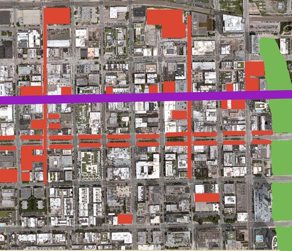
Fulton Market 2.0 is an ambitious project to say the least, but it showcases the interventions that are necessary to build free, green, public space in a complicated location. All of these phases combined are designed to preserve the neighborhood's historic character, as the neighborhood is a historic district, to provide unparalleled access to public space, and to combat gentrification through affordable housing. Shown in Figure 9 is a full map of Fulton Market 2.0's phases with Phase 1 in purple, Phase 2 in red, and Phase 3 in green. As can be seen in this image, the project will leave almost no part of the neighborhood untouched. While change can sometimes be scary, the benefits in tourism, connectivity, resident life, public health, and many more through a greener Fulton Market will positively impact both the neighborhood and the city at large.
[Figure 9: Hand-Drawn Full Map of Fulton Market 2.0 And Its Phases]
Gleason, Will. “High Line NYC: Full Guide to the Elevated Park Including What to Eat.” Time Out New York. Time Out, July 1, 2022. https://www.timeout.com/newyork/parks/highline.
Koziarz, Jay. “Would You Visit a Park on Top of the Kennedy Expressway?” Curbed Chicago. Curbed Chicago, January 14, 2020. https://chicago.curbed.com/2020/1/14/21065818/cap-kennedy-expressway-park-west-loop.
“Oculus Transportation Hub.” Official World Trade Center. Accessed December 5, 2022. https://www.officialworldtradecenter.com/en/local/learn-about-wtc/oculus-transportation-hub.html.
Roeder, David. “'Cap the Kennedy' Plan, Dormant for Years, Still Has Backers.” Times. Chicago Sun-Times, January 10, 2020. https://chicago.suntimes.com/2020/1/13/21059587/kennedy-expressway-open-space-deck-over-highway.
Sheppard, Seairra. “Toronto's Curbside Patios Made 49 Times More Money than the Parking They Replaced.” Strong Towns. Strong Towns, November 28, 2022. https://www.strongtowns.org/journal/2022/11/22/torontos-curbside-patios-made-49-times-more-money-than-the-parking-they-replaced.
Social Mix
Upon reviewing demographic data on Fulton Market gathered from Social Explorer, one finds a neighborhood that is very homogenous in nearly every way. It is no secret that Fulton Market is a gentrifier neighborhood, it has been since the former industrial land was rezoned, and its demographics match that status. For ease of comparison, the Simpson Diversity Index results were transformed into a 10-point scale. What is seen here is that Fulton Market ranks half as diverse as the greater city of Chicago on race with a score of 3.32/10 versus 6.02/10. This lack of diversity makes Fulton Market an interesting case, given that the West Side Region of Chicago scores above average for racial diversity at 6.58/10. It is also not diverse on the education front, scoring a 6.4/10 versus the Near West Side's, Greater West Side's, and Chicago's respective 6.44, 7.17, and 7.39. Finally, it is not diverse in terms of age, scoring a 6.43/10 compared to the city's 9.25, region's 9.22, and community area's 8.60.
This data all begs the question: why does Fulton Market lack diversity? The answer lies in the neighborhood's character, as illustrated by the 3 B's: bars, bistros, and bitcoin boys. Fulton Market is built to attract the white-collar, middle-aged worker with its sports-bars, high-paying corporate/tech jobs, and expensive housing. When these factors combine, the result is a neighborhood climate that is hostile to anyone who makes under a 6-figure salary. The makeup of the neighborhood only reinforces this inference, with a whopping 83.6% of residents older than 25 having graduated with a college degree, with 0% (yes zero) having no high school education or equivalent. Additionally, 49.6% of residents over 25 have a graduate degree. This is caused mostly by the plethora of consulting and tech jobs that have moved to the area, enticing many workers to follow in order to live close to work. The age demographics support this as well, with 63% of residents being between 25 and 44 years old, which is the prime age demographic of the white-collar office crowd. As a result of these factors, Fulton Market has a high population of career-oriented people, but also a low population of families. The data shows that 64.8% of residents are living without families, which makes sense given that the neighborhood has no playgrounds, one (private) school, and a food scene geared toward those 21 and up. The price of homes is also worth analyzing and is a probable cause behind the lack of racial and educational diversity within the neighborhood. Most homes (41.8%) are priced between $500,000 and $749,999, which is a price out of reach for many people, even those who are highly-educated or relatively well paid. These housing prices are certainly a factor behind Fulton Market's 76.3% white population as well, as many people of color do not have access to the educational resources and job opportunities to make them able to earn the required salaries to purchase a home there. With all of these factors and data combined, Fulton Market is shown to live up to its reputation as a place for adults and professionals only.