Overview
Social Mix
Public Space
Amenities
Connections
Final Project
Size
While it's difficult to approximate the exact population of the neighborhood, as its boundaries do not align perfectly with Census tracts, based on an approximation of Census tracts and block groups, Cabrini-Green is home to roughly 8,000 people. While this is somewhat larger than the ideal neighborhood of 5,000 as proposed by early planners like Clarence Perry, the geographic extent of the neighborhood is relatively small and contained.
Today, there are few visible signs demarcating the neighborhood from its surroundings. On my walk through the neighborhood, I saw no signage referencing "Cabrini-Green." Instead, realty agencies advertised the neighborhood's proximity to downtown, schools and community centers referenced the city of Chicago rather than any particular neighborhood, and the "for lease" signs hanging on new developments identified the neighborhood only as part of the larger geographical area of the Near North Side. In contrast, Old Town, just a few minutes away by foot, was easily identifiable by the large iron-grated signs reading "Old Town" on the neighborhood's most trafficked streets.
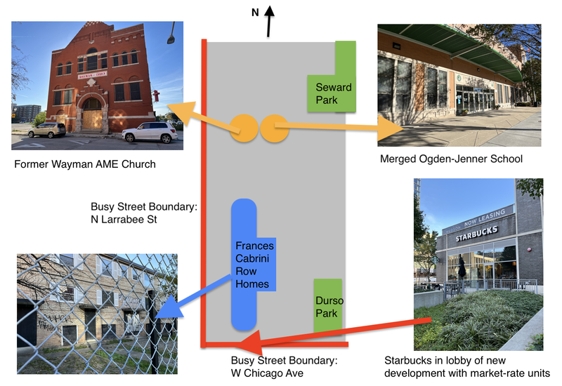
When I visited the neighborhood on a sunny Saturday afternoon, there were few cars on the street or pedestrians on the sidewalk. While I spotted some young adults walking their dogs near the gated townhomes closer to the north side of the neighborhood, the sites of the former Cabrini-Green high-rise towers were almost completely empty. On both W Chicago Ave, which bounds the neighborhood from the south, and N Larrabee St, which bounds it from the west, I was the only pedestrian. The lack of people on the street may be due to the fact that the majority of the neighborhood is residential space, and that a primary factor attracting residents to the neighborhood in the first place is that is makes for an easy commute to already-existing jobs downtown.
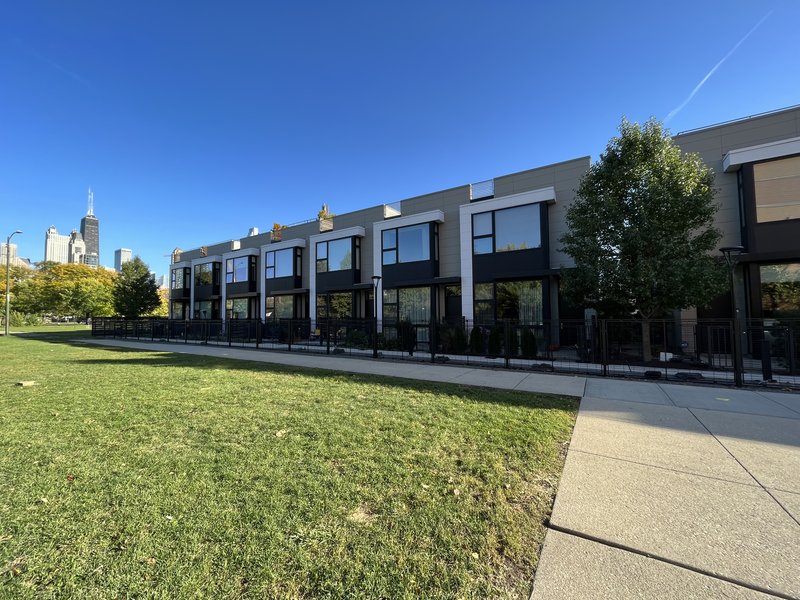
[Above: New townhomes near the former William Green high-rise towers]
Cabrini-Green is home to a large number of open green spaces and parks, but few of these public green spaces provide any shared facilities for residents, whether that be benches, a well-groomed sidewalk or trail, or public bathrooms and trash cans. This too contributed to the sense that this was a neighborhood without a clearly-defined center or identity. Even the streets near neighborhood institutions like the Jenner-Ogden elementary school that often serve as neighborhood centers were little-trafficked; the school sat directly across from the now-closed Wayman AME Church that once served a large congregation of predominantly Black residents of the public housing project—likely acting as a point of neighborhood identity and cohesion—but now serving to shed light on the lack of central gathering places or strong identifying places.
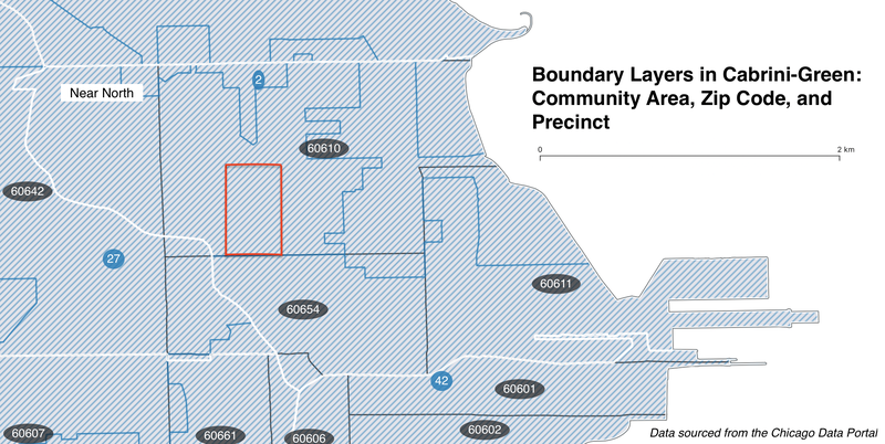
This map depicts the current boundaries of the community areas (in white), zip codes (in black), and ward precincts (in blue) to which Cabrini-Green belongs. The neighborhood boundaries here are roughly outlined in red. As shown above, the entirety of Cabrini-Green, as a relatively geographically contained neighborhood, belongs to the same community area, zip code, and precinct.
Named after the public housing projects that were home to upwards of 15,000 residents at their peak, Cabrini-Green today is a neighborhood in flux, with the boarded-up Frances Cabrini Rowhouses sitting across the street from new market-rate condos from private developers.
Before the neighborhood was known as Cabrini-Green, it was known as "Little Hell," due to the nearby oil refinery on Hobbie St and the slumlike conditions in which the majority European immigrant population lived. In a 1929 book, sociologist Harvey Zorbaugh dubbed the Lower North community to which the neighborhood belonged "The Gold Coast and the Slum," observing the mansions and wealth directly to the east of where of Little Hell. Today, Hobbie St is home to both the neighborhood's newly merged Ogden International-Jenner School, the empty lots where public housing units once stood, and the Basecamp River North development of new mixed-income townhomes. The transformation of the neighborhood from the early 20th century to what it looks like in the 2022 is tied to the extensive Cabrini-Green public housing projects that gave this neighborhood its identity in the mid-to-late 20th century.
In the 1940s, the city of Chicago demolished the shanties and dilapidated homes of Little Hell and began constructions on the first part of this extensive Chicago Housing Authority project, starting with the Frances Cabrini Homes. Today, these rowhomes are the only remaining structures from the Cabrini-Green public housing, although the majority are boarded-up and empty; the last of the high-rise towers that became popular media symbols of the failures of public housing was fully demolished in 2011. But today, rather than the city of Chicago stepping in to to redevelop the area, the neighborhood has become a desirable commercial location for private developers to build new market-rate units.
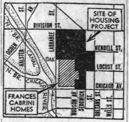
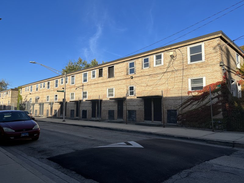
[Above: The Frances Cabrini Homes today, fenced off and boarded-up]
The original Cabrini-Green Homes were home to a racially heterogeneous mix of residents, primarily housing war veterans (due to repurposing for World War II), some of Little Hell's original Italian and Irish population, and increasingly Black Americans, who moved in as they continued to be excluded from affordable, quality housing in Chicago's racially segregated neighborhoods. Early residents were also carefully screened to meet the CHA's criteria for "low-income" but now "extremely low-income," as the city embarked on an urban renewal project with the hopes of remaking Little Hell into a safer neighborhood and a convincing argument for the power of public housing.
In the 1960s, CHA built the William Green Homes on Division St, adding 1,000 units and introducing a new type of housing—high-rise buildings instead of the previous two-story rowhomes. Arguably in part because of the way the high-rise buildings isolated residents from their surroundings and allowed for the extreme spatial concentration of poverty, but also because of factors like neglect and poor maintenance by the city and under-funding and de-prioritization of the CHA, by the 1970s, Cabrini-Green was no longer a "model" of public housing, but an oft-derided example of its failures. The predominantly Black residents of Cabrini-Green experienced a rise in crime, poverty, and further disinvestment in the neighborhood. By 19956, the City had announced a new plan for affordable and public housing in Chicago and planned for the demolishment of the majority of Cabrini-Green.
Since demolition began at the turn of the century, former residents of the Cabrini-Green homes have been protesting how they have been priced out of the new Cabrini Green neighborhood. While new mixed-income development was supposed to provide replacement housing for public housing residents, displaced residents were mostly been scattered across the city of Chicago due to the slow pace and low quantity of construction, with fewer than 400 replacement public housing units built as of 2012, more than a decade after residents were first displaced. In 2015, following years of federal litigation, Chicago agreed to convert at least 176 units of the Frances Cabrini rowhomes to public housing and add additional incentives for developers to build low-income units.
Bittle, Jake. “What Is the CHA Doing?” South Side Weekly, April 16, 2019. https://southsideweekly.com/cha-plan-for-transformation-haunts-chicago/.
Chicago Reader. “‘A City within a City.’” Chicago Reader, March 30, 2021. http://chicagoreader.com/news-politics/a-city-within-a-city/.
Chicago Tribune. “Cabrini-Green Timeline: From ‘War Workers’ to ‘Good Times,’ Jane Byrne and Demolition.” Accessed October 5, 2022. https://www.chicagotribune.com/news/ct-cabrini-green-timeline-20201220-zti7msps6zerxpye72h6qxbfxy-story.html.
Magnusen, Emily. “The Fight to Stay at Cabrini-Green Chicago Public Housing Special.” Public Interest Law Reporter 16, no. 2 (2011 2010): 176–82.
Ruiz-Tagle, Javier. “The Broken Promises of Social Mix: The Case of the Cabrini Green/Near North Area in Chicago.” Urban Geography 37, no. 3 (April 2, 2016): 352–72. https://doi.org/10.1080/02723638.2015.1060697.
Vale, Lawrence. “Housing Chicago: Cabrini-Green to Parkside of Old Town.” Places Journal, February 20, 2012. https://doi.org/10.22269/120220.
Also referenced: GIS data from the Chicago Data Portal and Census.gov.
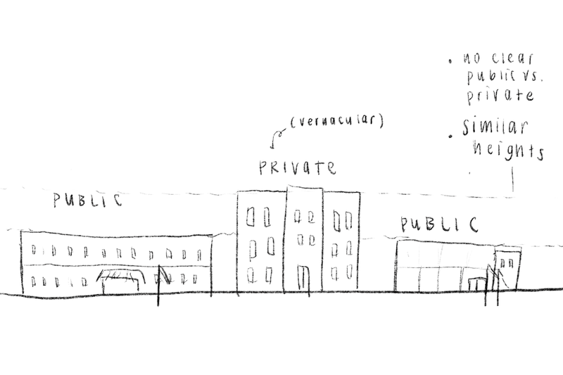
[From left to right: Rough sketches based off the Ogden-Jenner school on N Cleveland Ave, the townhomes on W Hobbie St, and the Chicago Police Department on N Larrabee St]
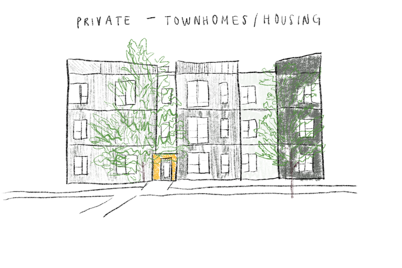
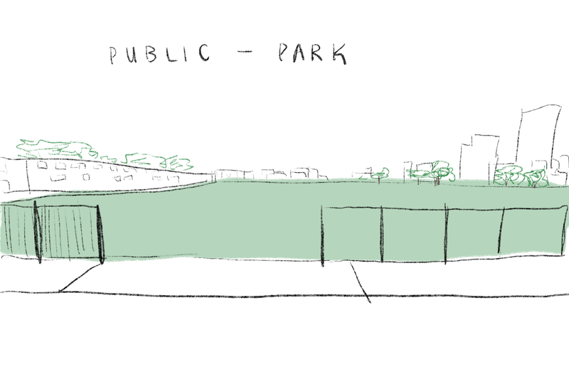
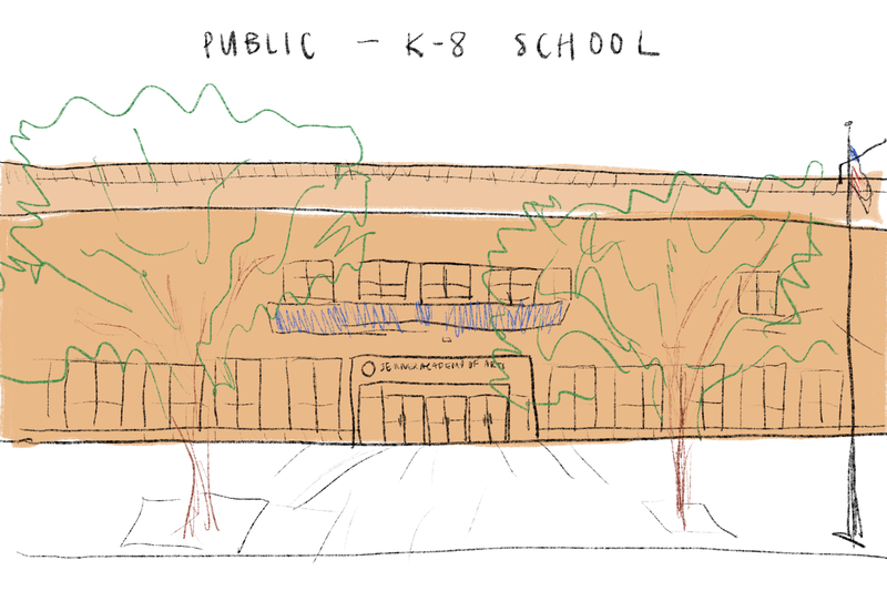
Leon Krier writes in "Nature of the Architectural Object" that architectural objects ought to have a natural hierarchy. Civic buildings and the public elements of a city, for example, are privileged objects with coherent forms and meanings. Private buildings, on the other hand, hold utilitarian rather than monumental meaning and their form ought to reflect that function. In Cabrini-Green, there are no public buildings of the type that Krier would call monumental and sacred. The tallest buildings, for example, are the type of multi-story buildings with residential units that Krier deemed "fake monuments," while civic buildings like the neighborhood school and police station do not have easily distinguishable architectural styles. In the diagram above, I sketch a landscape where public and private buildings do not follow an easy private vs. public visual typography. This is the case in Cabrini-Green, where public and symbolic buildings like schools, churches, and even parks do not have a distinctive visual language, but instead resemble private buildings like condos, townhomes, and retail centers.
The above sketches of townhomes (private building), a park (public space), and a school (civic building) are all based on buildings located in Cabrini-Green. From the view on the street, it's difficult to distinguish the public realm from the private realm. As visible in the diagram, even the traditional public space of the park is not clearly demarcated as open to all. This park, called the Durso Park, is not a place for mixed uses and has no amenities for visitors. While there is a clear entrance onto the street where the fencing opens up, the sidewalks around the park are not frequently trafficked by pedestrians. When I visited, the entrance to the park was partially obstructed by the cars parked right on the curb in front. Even though the park is physically open, accessible by foot, and bears no signs of private ownership (e.g., no signage or security guards), I couldn't help but wonder whether the space was open to visitors when I visited the neighborhood because it was so empty. Perhaps because of these design flaws, there were almost no people at the park when I visited, even though the weather was quite good.
The school and townhomes provide another interesting case study because they are located nearby each other. While the school is not an example of monumental architecture in the style of Krier's monuments and civic buildings, it is distinguished from the surrounding private buildings because of the American flag flow in front and the clear signage on the building, entrance, and sidewalk. The townhomes, on the other hand, are arguably a very recognizable type of vernacular architecture that some online commentators call "gentrification buildings," with its boxy, vaguely modern, black/gray/white facade. Looking at this block alone, the school as a public space is also distinguishable from the townhomes because of the vernacular style we associate with private multi-unit buildings in neighborhoods undergoing rapid real estate development like Cabrini-Green.
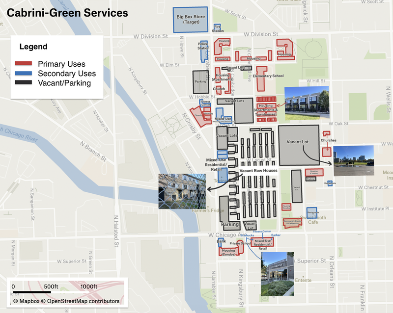
Access an interactive version of the map (with zoom function to view text and images) here.
Jane Jacobs writes that primary uses are those uses which serve as "anchorages," bringing people to the neighborhood (161). Examples include housing, places of work like offices and factories, education and recreation facilities, and, to a certain extent, arts and cultural institutions like museums. Even if a certain place doesn't fall within one of the aforementioned categories, it may still act as a primary use if it effectively attracts people to the neighborhood. In Cabrini-Green, there is little diversity of primary uses, in part because much of the neighborhood is residential-only and in part because there are so many vacant lots and uncompleted construction projects. Apart from housing uses, most of the primary uses are located on the periphery of the neighborhood on streets like W Chicago Ave and W Division St, further away from the vacant Frances Cabrini Homes and the empty lots. The neighborhood's primary uses fall into two main categories: housing and education/recreation.
The neighborhood's most prominent primary use is housing, with a mix of apartments, condos, and townhomes. Beyond housing, an example of education/recreation as a primary use is the Jesse White Community Center and Fieldhouse, which is run by the Chicago Parks Department. The fieldhouse includes amenities like a computer room and indoor gymnasium, and it is the site of several after-school programs for local youth. Although this is an unscientific measure, I also found that the Jessie White Community Center and Fieldhouse has the second-highest number of online Google Reviews among all the sites in the neighborhood, thus suggesting that it is comparatively well-used and attracts new people to the neighborhood.
What most detracts from Cabrini-Green's mix of primary uses is the lack of work opportunities. Jacobs writes that the two primary uses of housing and working dovetail nicely together because they provide some users to liven up the streets during the work day and some to liven up the streets during the evenings and weekends. Looking at Cabrini-Green, however, there are no large office spaces or businesses in the core of the neighborhood. This aligns with developers' pitch of the neighborhood as a convenient home for people who commute downtown to work, but it does mean that the neighborhood draws few users from outside the neighborhood; people are not commuting into the neighborhood to work during the weekday. There are some corporate offices right outside the neighborhood's boundaries, directly east of the river, but their relative distance from the means that they are unlikely to attract users to the neighborhood itself.
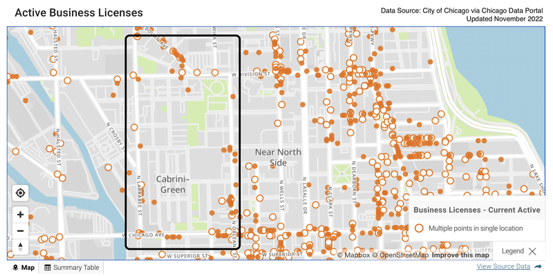
Each orange dot represents an active business license. Data set accessible here.
Both this lack of work opportunities to draw a diversity of primary users and the resulting lack of secondary diversity are illustrated by the map above, which shows all active business licenses in the Cabrini-Green neighborhood and surrounding region. Just a cursory glance reveals that the vast majority of the neighborhood, where the elementary school, parks, and housing facilities are located, is actually home to no licensed businesses at all.
Without a robust mix of primary uses, Cabrini-Green cannot consistently draw people to the neighborhood, resulting in little demand for the types of enterprises that Jacobs calls "secondary diversity." These are the specialized shops and services that "grow in response to the presence of primary uses, to serve the people the primary uses draw" (163). Since Cabrini-Green mostly serves residential primary use, the types of services in the neighborhoods are not very mixed. There are some restaurants, cafes, fitness centers, and beauty/grooming centers, but because these services primarily exist to service one type of primary user (residents), few exemplify the type of urban innovation that Jacobs speaks. Rather than creating a "complex pool of use" and attracting a diverse set of people to the neighborhood, Cabrini-Green runs a narrow gamut of primarily residential uses.
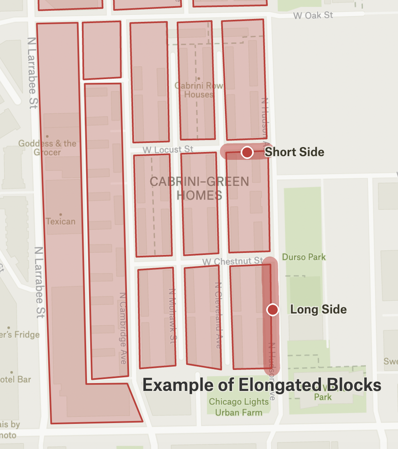
The Lexicon of New Urbanism reduces the variety of blocks down to three key categories: the square block, elongated block, and irregular block. Most of Cabrini-Green's blocks are best categorized as elongated blocks. Unlike square blocks, elongated blocks "provides two distinct types of frontage," with a short side (usually fronting the busier, higher traffic street) and long side (usually fronting the quieter, lower traffic street). Example of these elongated blocks with short and long frontages are provided in the graphic below, which maps the shape of the blocks in a portion of the Cabrini-Green neighborhood near the Frances Cabrini Row Houses.
II. Network Types
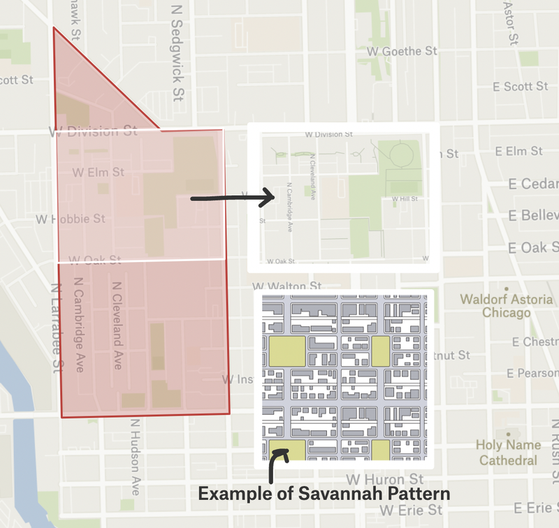
The network of the neighborhood is the arrangement of streets and thoroughfares that constitutes the essential structure of the area. Cabrini-Green is most accurately categorized as following a Savannah pattern. This type of pattern has straight lines, a gridded web of streets, and relatively even dispersal of trafficked streets through the neighborhood, thus facilitating an intuitive directional orientation and controllable lot depths. As common in a Savannah pattern, Cabrini-Green has mostly straight lines and a gridded street system, with lots of varying width and depth but generally straight and rectangular shapes. This allows for the relatively even dispersal of trafficked streets throughout the neighborhood, as demonstrated in the graphic below, which maps a portion of the Cabrini-Green near the well-trafficked W Division St in the north end of the neighborhood.
II. Thoroughfare Types
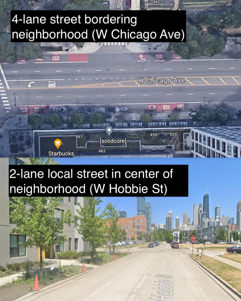
Cabrini-Green has higher-capacity thoroughfares on its edges, and lower-capacity thoroughfares on the smaller local streets within the neighborhood. For example, Hobbie St next to the local elementary school is short and has two lanes, but W Chicago Ave bordering the south of the neighborhood is relatively well-trafficked and has a higher four-lane capacity for vehicles. The graphic below compares and contrasts the two thoroughfares using images from Google.
Most of Cabrini-Green's minor thoroughfares are also connected to major thoroughfares outside the neighborhood, although sometimes this is not perfectly efficient. Hobbie St, for example, terminates on one end into N Cleveland Ave, which itself ends where it meets W Division St. W Division is a major thoroughfare that runs beyond the boundaries of the neighborhood, but to navigate there from a local street like Hobbie St might require some extra foresight. The variety of itineraries and the dispersal of traffic is thus affected. This is related to a second issue, which is that there are higher-capacity streets acting as edge thoroughfares, but no high-capacity streets running through the center of the neighborhood itself. Finally, the neighborhood is almost entirely made up of streets, with no highways/parkways or major boulevards in or directly bordering the neighborhood.
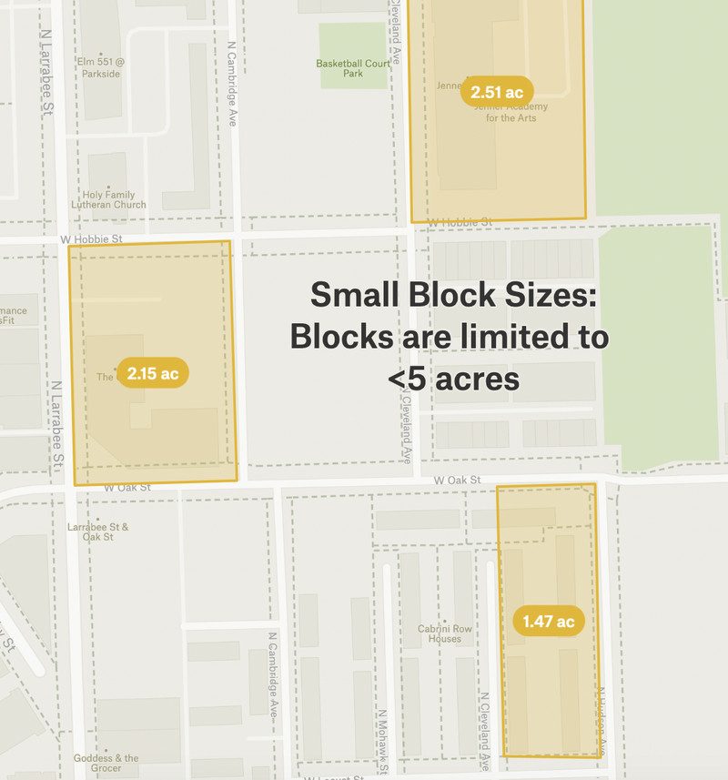
Cabrini-Green meets many of the standards for good connectivity. For example, the neighborhood has few cul-de-sacs and few dead-end streets, and all local streets have accompanying pedestrian walkways. Intersections within the neighborhood are also relatively small and facilitate easy pedestrian crossing and access, with no intersections longer than 600 feet, except for the most heavily-trafficked streets bounding the neighborhood like W Division St. The diagram below shows some typical block sizes in the neighborhood, showing that the average block size and street widths are on a scale accessible to pedestrians.
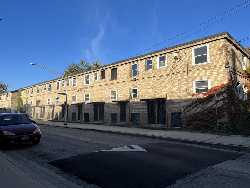
However, the greatest obstacle to connectivity in Cabrini-Green is the large area taken up by the mostly vacant Frances Cabrini Row Homes. These homes have not been torn down, and they sit in the geographic center of the neighborhood, right next to key neighborhood amenities and centers like the local neighborhood school and churches. However, the homes are fenced off, and some of the streets adjacent to the homes are no longer accessible to pedestrians or cars. Other streets adjacent to the neighborhood are still open for car and pedestrian access, but because the homes are visibly vacant and boarded-up, there is no sense of connection and no eyes on the street, such that these streets naturally appear to receive less traffic from residents. This creates a huge connectivity dead space right in the geographic center of the neighborhood. The image below shows a street view of some of these boarded-up row homes, which I took on site in the neighborhood. While you can see that the street is still open to cars, the block is very empty, and there are no people on the sidewalks or looking out onto the street.
While Cabrini-Green's small and regularly-sized blocks, easily navigable street network, and lack of cul-de-sacs and dead end streets should, in theory, increase the connectivity profile of the neighborhood, the health of its urban fabric suffers from the lack of traffic on some of its centrally-located local roads. The neighborhood demonstrates that even if the design of the neighborhood is well-done, it matters what types of uses and users are present. Cabrini-Green may not have an excess of cul-de-sacs, but the excess of vacant or unused lots makes some streets into effective dead-ends, where there is nothing to see but boarded-up homes for several blocks.
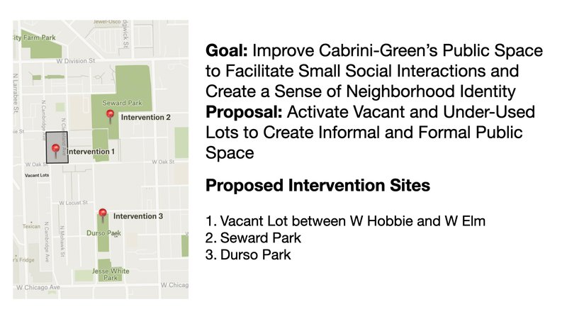
Examining Cabrini-Green's social mix, public space, amenities, and connectivity reveals a diverse but rapidly developing and changing neighborhood. Due to its recent history as the site of a Chicago public housing project, Cabrini-Green has more economic and racial diversity than its neighbors in the Near North Side, but it also suffers from an excess of dead space stemming from recent demolitions, new construction, and now-vacant public housing. To better facilitate small social interactions and foster a sense of neighborhood identity, I propose three interventions focused on repurposing under-used and vacant lots in the neighborhood, thus transforming dead space into active space and providing better and more public space. These interventions are especially needed in Cabrini-Green because of the influx of new residents and the ongoing transformation of the neighborhood from a predominantly low-income community to a mixed-income community: Well-used and accessible public spaces can serve a key role in facilitating regular interactions and a sense of community between Cabrini-Green's diverse residents.
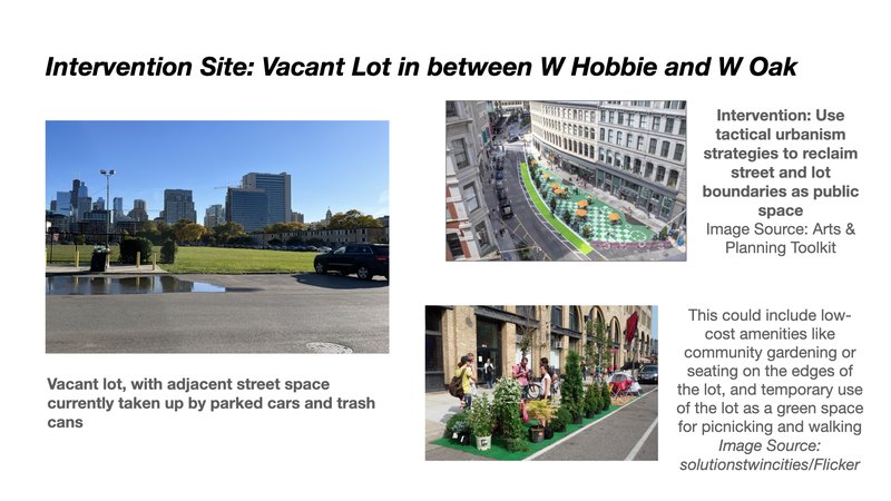
This vacant lot between W Hobbie and W Oaks is the size of an acre and occupies valuable space in the neighborhood near the local elementary school. Because of Cabrini-Green's location near downtown Chicago and high-demand neighborhoods like Old Town and the Gold Coast, vacant lots like these are not abandoned but already privately-owned and waiting for new development. Thus, I propose an intervention on a shorter time-scale: using tactical or guerilla urbanism strategies to reclaim the vacant lot as community public space. These strategies will be low-cost and easily removable, building on the ways that some residents are already using the vacant lot as a space to walk their dogs and relax on sunny days. In particular, reclaiming the street space directly adjacent to the lot by placing temporary street furniture and painting expanded sidewalks, and adding community gardening amenities or green features to the edges of the park will help make the lot feel less like a vacuum in the middle of the neighborhood.
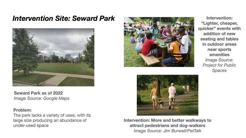
Seward Park is one of three Chicago Park District sites in the Cabrini-Green neighborhood. It is also the largest of the three parks, totaling almost nine acres. While Seward Park has athletic facilities and a fieldhouse, on my visit to the park, there were few users. A visit to the park's website also reveals that the park does not currently offer any free or low-cost activities for families or young children, and no outdoor activities in the fall, summer, or spring that utilize the full range of the park's open green space. Parts of the park also have few pedestrian walkways or seating and activity areas like benches or picnic tables. The park is thus under-used, appearing to passing pedestrians like an empty expanse of green rather than a welcoming and inviting space. To address this problem, I propose a series of "lighter, quicker, cheaper" events inspired by the Project for Public Space's revitalization of public space in downtown Providence, Rhode Island. In particular, adding more benches, seating, and tables in the empty expanses of the park, scheduling and promoting free activities for families like arts and games, and re-designing the empty areas of the park to include pedestrian walkways for activities like dog-walking will help attract users to the park.
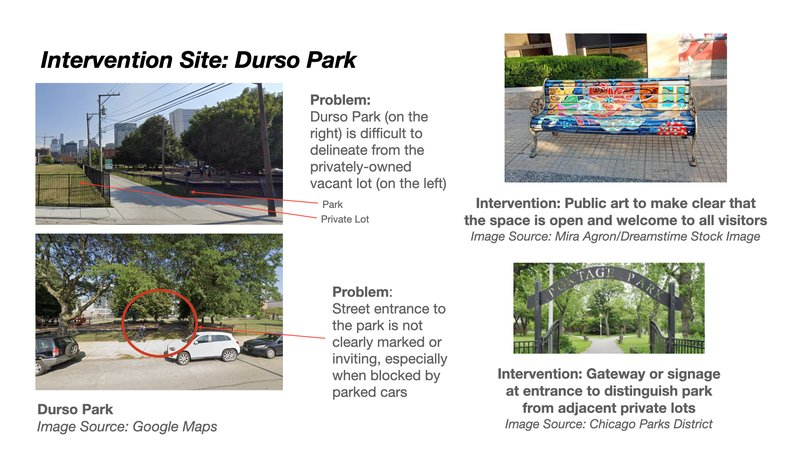
Durso Park is the smallest park in Cabrini-Green, located right across the street from the now-vacant Frances Cabrini row homes and with no fieldhouse or activities. However, given the nearby Jesse White Community Center just a block to the south, I believe that the park's lack of activities is not its greatest problem: rather, the under-use of the park likely stems from the fact that it is surrounded by vacant lots and housing, both of which are unwelcoming and private spaces. The park is right next to a grassy vacant lot, which looks much like public green space but is actually a private vacant lot waiting for development, and right across the street from fenced-up and vacant public housing. The excess of vacant and dead space nearby makes the park feel less safe, as there are less eyes on the street, and it also makes it difficulty for a passing pedestrian to distinguish the park as a public space where they are welcome. To address this problem, I propose adding public art and murals on the boundaries of the park and a clearly-marked, street-facing entrance to the park.
Social Mix
Basic Demographics
To summarize the basic demographic data available for Cabrini-Green, I used ACS 2020 5-Year estimates for three Census block groups: Tract 804, Block Group 1; Tract 819, Block Group 1; and Tract 8383, Block Group 1. While these block groups do not correspond exactly to Cabrini-Green's boundaries — for example, the southeast corner of the neighborhood belongs to a different block group which I excluded because the majority of the block group is outside the neighborhood boundaries — they should be accurate enough to provide a broad overview of the neighborhood's overall demographics.
The tables communicate aggregated data for all three block groups in the neighborhood. I wanted to note a few key demographic differences between these block groups. First, the southern portions of the neighborhood closer to downtown are much whiter than the northern portions of the neighborhood. The Block Groups in Tract 819 and 8383 are majority white, while Block Group 1 in Tract 804 in the northernmost portion of the neighborhood is majority Black. Second, while median house value for owner-occupied units did not vary greatly across the three block groups, median gross rents varied significantly. In Tract 819, Block Group 1, which covers the western portion of the neighborhood and includes the former sites of the Cabrini-Green public housing project, median rent is $2,472—more than double the median rent for the aggregated neighborhood. Finally, Tract 819, Block Group 1 was also the only block group where owners occupied the majority of units; in the other two block groups, the proportion of renters was much higher than of owners.
Diversity
To calculate my Simpson Diversity Indices, I used the same race, age, and educational attainment variables that I used to compile the basic demographic tables above, again using ACS 2020 5-Year estimates. The community area (Near North Side) and the region (Near North Side) to which Cabrini-Green belong share the same boundaries, so the category of "Near North" in the table includes data that applies to both designations. Since the Census Bureau does not collect data on the community area level, I calculated the indices by summing data from each of the tracts included in the community area: tracts 801, 802.01, 802.02, 803, 804, 810, 811, 812.01, 812.02, 813, 814.01, 814.02, 814.03, 815, 816, 817, 818, 819, and 8422.
Analysis
Based on the Simpson Diversity Indices for the Cabrini-Green neighborhood, the Near North Side community area/region, and the City of Chicago, Cabrini-Green is significantly more diverse than the Near North Side but slightly less diverse than the city as a whole. In particular, residents of the Near North Side are more likely to be white and to have a higher level of educational attainment than residents of Cabrini-Green or Chicago. In other words, Cabrini-Green is distinguished from its immediate community area by virtue of its racial and educational diversity, as it is home to more non-white residents (particularly Black residents) and more residents with a high school diploma or less. Given that Chicago, like many big American cities, is known for having a history of racial and economic segregation, it makes sense that individual community areas and regions like the Near North Side are less diverse than the city as a whole. Cabrini-Green's relatively recent history as the home to a large public housing development likely contributes to its relative diversity in the context of the Near North Side. However, while I would argue that Cabrini-Green today is a diverse neighborhood, it's unclear whether the neighborhood will be able to retain its economic or racial diversity or if the neighborhood will, like the nearby River North or Gold Coast neighborhoods, become less affordable or accessible to residents of different socio-economic classes.