Overview
Social Mix
Public Space
Amenities
Connections
Final Project
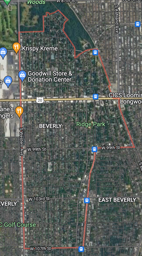
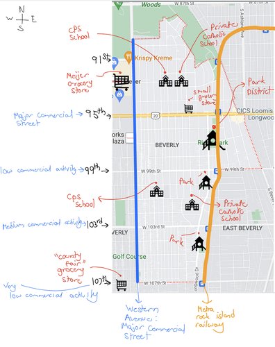
Beverly has a population of 11,844 people. It covers an area of about 1216 acres (1.9 square miles). Its geographic size is comparable to that of a large public 4-year college. It stretches from 87th street to the north to 107th street to the south. Its most western boundary is Western Avenue. North of 99th street, Beverly Boulevard is the eastern boundary. South of 95th street, the Rock Island Metra railway line is the eastern boundary.
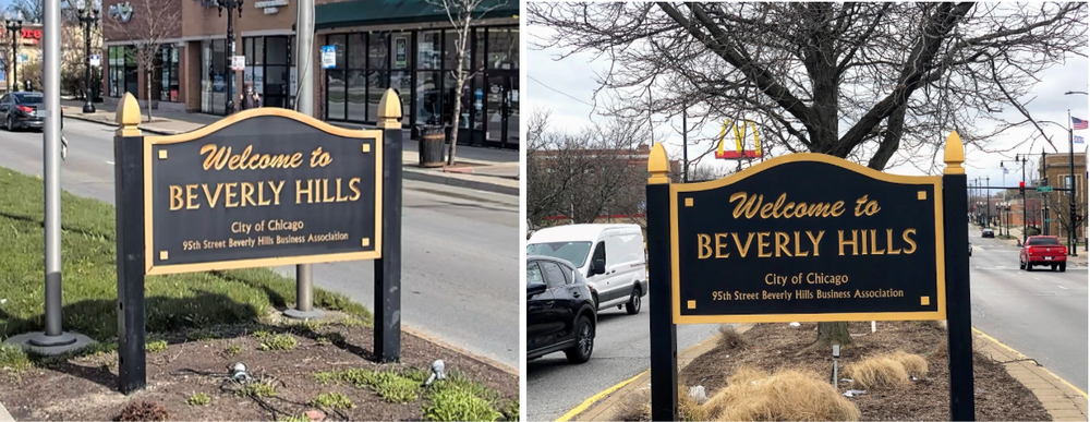
"Welcome to Beverly Hills" signs: The first sign is located east of the intersection of Western Avenue and 95th Street. The second sign is located west of Ashland Avenue and 95th Street. These are the only two signs that let people know that they have entered Beverly.
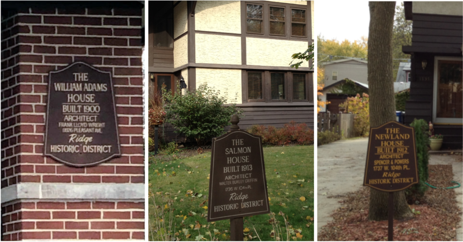
Ridge Historic District Signs: Many blocks in Beverly have a house or two that have a Ridge Historic District sign in front of it. These signs usually list the date the house was built, along with the name of the architect. These signs pay homage to the fact that these homes were built upon the only ridge in Chicago. These signs are only located in two Chicago neighborhoods: Beverly and Morgan Park.
Architecture and Houses: Lots of houses in Beverly are larger plots of land. Some homes have 1 or 2 acres. Not many neighborhoods in Chicago have these big lots (most lots in other neighborhoods are 25 feet by 125 feet). You can find almost every type of architectural design in Beverly. There are 4 Frank Loyd Wright houses. Other famous architects include George W. Maher, Walter Burley Griffin, Daniel Burnham, and Howard Van Doren Shaw. The Frank Loyd Wright houses have the ridge historic district signs too. While there are some apartment buildings in Beverly, single-family homes are the main housing type in Beverly. Other beautiful homes in Beverly lie along Longwood Drive.
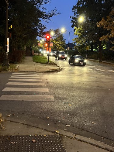
Longwood Drive/Edge of Ridge: Notice the stairs? Beverly is built upon a ridge! For Chicago being so flat, it is definitely unique that Beverly has streets that bike riders struggle to go up. Longwood Drive runs along the edge of the ridge. Longwood Drive has some of the most beautiful homes in Beverly. West of Longwood is the top of the ridge. Although Beverly is not divided into two separate neighborhoods along this edge, it definitely acts as a kind of dividing boundary.
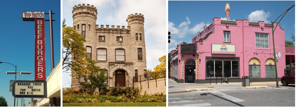
Well-Known Places: You may wonder, "Why is there a castle in Beverly?" You will find out from further exploration on this website. But yes, the castle does stick out, as it is also at the top edge of the ridge. The Original Rainbow Cone on the far right and Top Notch Burgers on the left are two Beverly favorites. Rainbow Cone has quite the design to it, too!
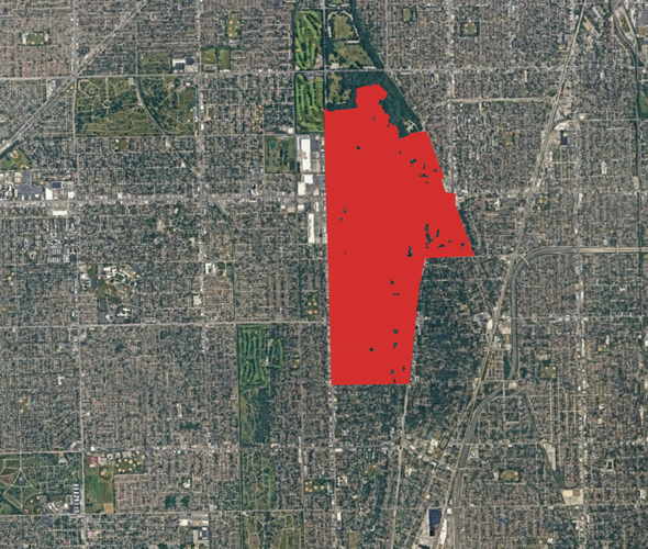
Beverly Shaded in Red
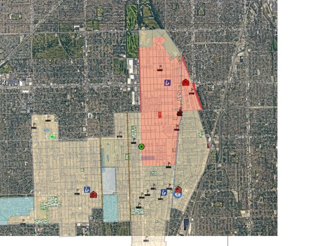
19th Ward Layer: The 19th Ward includes Beverly, East Beverly, West Beverly, Morgan park, and Mount Greenwood. (Beverly, not east or west, is shown in red.
Beverly was not originally in Chicago when it was first made. The neighborhood was originally a part of the village of Washington Heights. It was annexed into Chicago in 1890. It is believed that Washington Heights had the name that it did due to the ridges that quite literally gave the area "height". The rock island railway line began running around the 1870s. Stations that were in the Beverly area were known by the street name that they were connected to. One of those stations was at Beverly Hills and 91st. Then, in 1917, some agencies petitioned for the stations' names to be changed to Beverly Hills and the street number. It has been suggested that the Chicago Telephone Company spurred this movement, as the name Beverly was best suited for telephone use. From then on, people started to call the area Beverly Hills or simply Beverly.
Beverly has strong Irish roots due to immigrants moving here. Givin's Castle (on 103rd and Longwood) was built in 1887 under the direction of Robert Givins. His family was from Ireland, so he built it based on the architecture of castles in Ireland. It originally functioned as his mansion, but now it is a unitarian church. So the area was predominately Irish in the early 1900s. But then it started to transition as black people started to move to the area. In the 70s, the Beverly Area Planning Area Association made it a clear goal to integrate Beverly racially. As many neighborhoods experienced white flight, Patrick Stanton of BAPA worked to make it a welcoming place for new incoming black residents and to keep current white residents. In his plan called "Beverly Now", Stanton said, "There are thousands of black people who want homes, they can afford homes, and certainly they deserve to live where they can afford. They should be welcomed but scattered" BAPA did not want there to be a concentration of all-black residents on just a block or a couple of blocks. Stanton emphasized the importance of showing potential black residents available homes that were on blocks not already integrated so as to continue integrating blocks in the neighborhood. Beverly is now one of the most racially diverse neighborhoods in the city of Chicago.
Citations
Heinemann, Walter F. “A History of Beverly Hills, Chicago.” The Weekly Review of Beverly Hills, Chicago, 1926. http://www.beverlyrecords.com/history%20of%20beverly1926.pdf
Moore, Natalie, et al. How Beverly Maintained Racial Integration and Fought off White Flight. Youtube, WBEZ, 26 Mar. 2014, https://www.youtube.com/watch?v=wDl-MDSpfrk.
Statistics Atlas. “Race and Ethnicity in Beverly, Chicago, Illinois (Neighborhood).” The Demographic Statistical Atlas of the United States - Statistical Atlas, Cedar Lake Ventures, Inc., https://statisticalatlas.com/neighborhood/Illinois/Chicago/Beverly/Race-and-Ethnicity.
Heinemann, Walter F. “A History of Beverly Hills, Chicago.” The Weekly Review of Beverly Hills, Chicago, 1926. http://www.beverlyrecords.com/history%20of%20beverly1926.pdf
Editor, Villager. “BAPA History: 'Beverly Now' Leads to Bapa Reorganization.” Beverly Area Planning Association, 2 Mar. 2017, https://bapa.org/bapa-history-beverly-now-leads-bapa-reorganization/.
“Historical Information.” BEVERLY, https://irishbeverlyethnicneighborhood.weebly.com/historical-information.html.
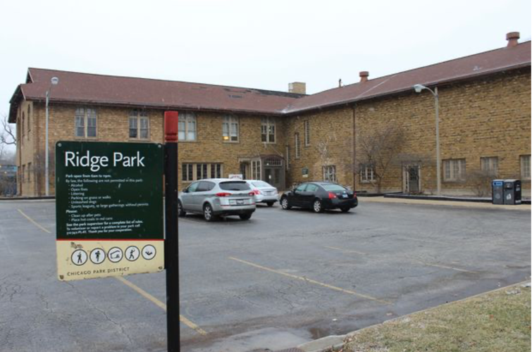
I wouldn’t say there is a true central area in Beverly, but rather that Beverly is made up of several mini-centers that are in no way complete when it comes to amenities. The park district is most central in terms of physical proximity to the entire neighborhood. Ridge park has two baseball fields, tennis courts, a playground, an indoor swimming pool, a gymnasium, some small fitness rooms, and a couple of office spaces/community rooms. Ridge park hosts a range of sports activities for children and adults in the neighborhood, but it doesn’t do much more than this. It is not located particularly close to any restaurants or stores, and most of the time, you will not use the park unless you have something scheduled there.
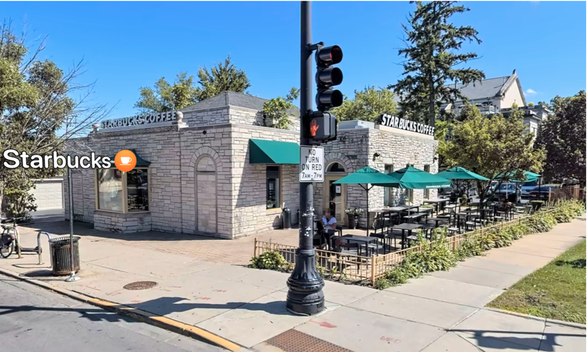
Since Beverly is pretty large in geographic area, it is likely that residents in the north side of the neighborhood associate different places with being the center point of their neighborhood than the south side residents. In south Beverly, 103rd and Longwood seems like a central area. The Starbucks which is on that corner has a beautiful outdoor patio that many people will hang around. There isn’t truly a “public space” on this street though. 99th and Walden has a place called Afro Joe’s which serves a very similar role as the Starbucks on 103rd. Otherwise, there is no true public space. It should be noted that both 103rd and 99th street are streets the metra line has stops at. These streets have commercial activity, but they are small enough and calm enough to act more as a neighborhood joiner than a divider. Both of these streets would benefit greatly from a better public space. They both have small businesses or cafes that people can enjoy themselves at, but if you are not spending money it might be hard to find a space to congregate.
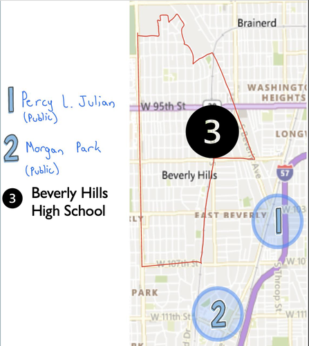
The 2 public schools in Beverly are west of longwood. They each feature a field, a playground, and a parking lot. Other than functioning as an educational institution, these places provide a place for children to play with friends. But considering that there is no quick access to businesses or shops, people don’t spend much time here unless they are bringing their kids to the park.
Although 95th street is a major commercial area where many residents spend their time, it acts as more of a divider between the north side of Beverly and the rest of it. North Beverly has two schools in the center of it, but these do not function as major public areas of congregation.
Would Beverly benefit from a more defined center? Most households in Beverly own a car. Many residents in Beverly can get by just fine without ever accessing businesses on 103rd or 99th street. If there were to be a development of some kind of center, that could be delayed for some time considering the development of the evergreen plaza on the west side of western in Evergreen Park (which is a suburb of Chicago). Many residents do their shopping in this area. There is a good argument for the alderman and community to try to support the development of the 99th and 103rd street corridors, especially their public areas, so people will continue to shop in Beverly. How big of a role does the east of western being a dry area (where no alcohol can be sold) play in there being these underdeveloped centers? Future restaurants and grocery stores could be attracted to these areas and start building even better centers in Beverly.
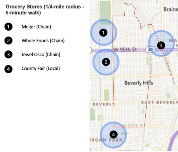
Practically all residents of Beverly do not live within a 5-minute walk shed of a grocery store. The walk shed around Meijer and Whole Foods cut a little bit into Beverly, but even then, residents have to walk across the busy street of Western Avenue, which is not pedestrian friendly. The Jewel Osco contains a larger portion of residents in its walk shed. The County Fair walk shed barely cuts into Beverly. The lack of grocery store walk sheds that are in Beverly demonstrates Beverly residents' reliance on cars. All of these stores contain large parking lots, but really no sidewalk's for pedestrians.
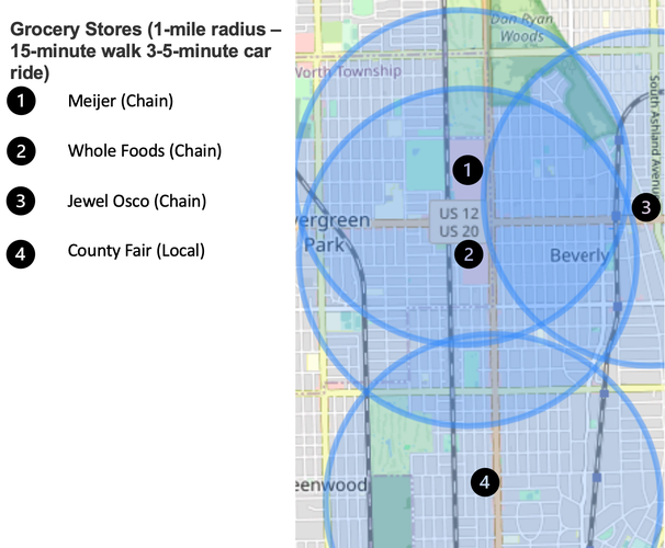
These are circles with a radius of one mile around the same grocery store. Most of these stores are accessible with either a long walk, closer to 15 minutes, realistically maybe over 20 for some residents. People in Beverly are car-dependent, and this map shows that the grocery stores are within a couple of minutes of driving All of Beverly is covered by this.
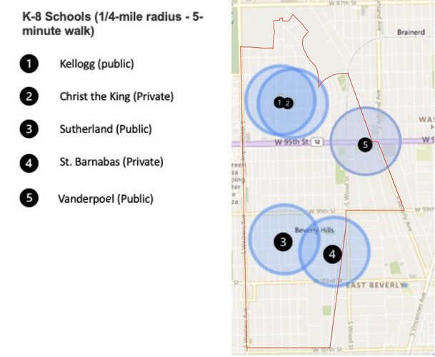
The elementary schools in Beverly are much more accessible than the grocery stores are. Practically all residents in North Beverly (north of 95th) are within a 5-10 minute walk of either Kellogg or Christ the King. Sutherland and Barnabas are also quite accessible, however, children who live close to 95th street or close to 107th street will have to commute between 10-15 minutes if walking to Sutherland. But then there is Vanderpoel on the east side of the neighborhood, which gives parents the option of sending their kids to a closer school.
There are no high schools in Beverly. So while the plethora of elementary schools does give young kids the ability to walk, high school students will have to either take public transportation or drive a car to get to their school.
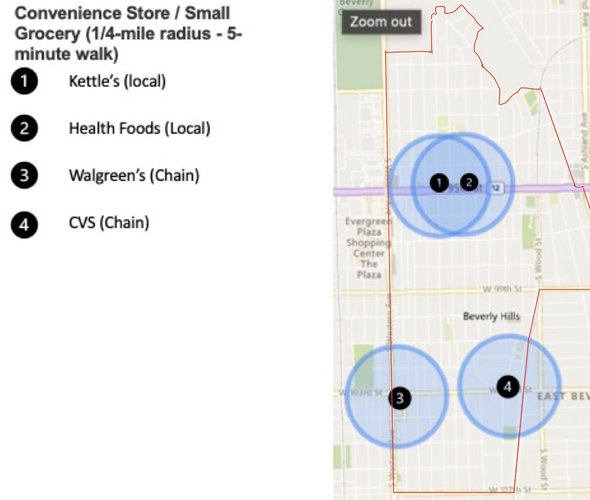
Two small convenience/grocery stores are located on 95th street, giving residents in the immediate area an option for quick things that they might need. The Walgreens and CVS cover a good range of areas in the southern part of Beverly. But many residents are not within a 5-minute walking distance of their homes.
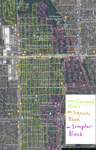
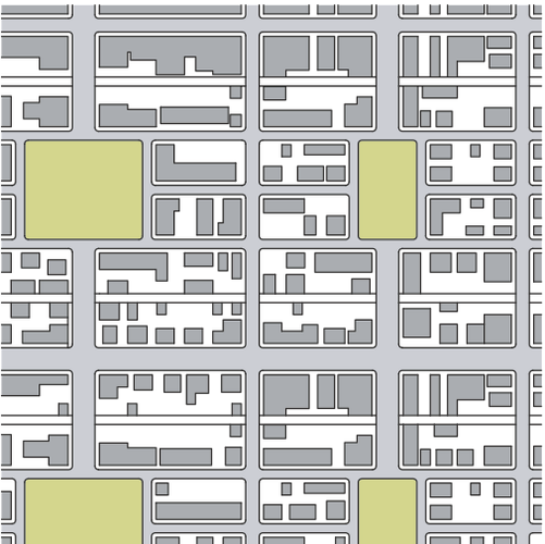
Green Blocks = Elongated Blocks (Large Majority), Pink Blocks = Irregular Blocks (Along east side of Beverly), Orange Blocks = Square Blocks (only 3-4 in Beverly)
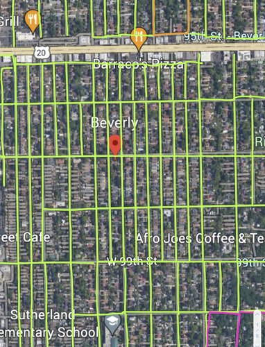
The blocks in Beverly are mainly of the elongated type, as shown in the diagram above. Elongated blocks overcome some of the drawbacks of square blocks. Lot depths do not very much along these types of blocks. These types of blocks are typically good for having alleys with easy access to parking space, like a garage. This access to parking in the alley is especially important in a neighborhood like Beverly, considering it is a car-dependent neighborhood. This also allows gives pedestrians more options for their route while walking. They do not have to walk to the end of a block necessarily to change directions.
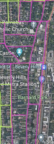
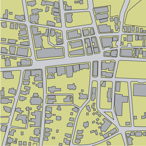
The second most popular block type in Beverly is the irregular block. Irregular blocks can be used to "organically negotiate sloping terrain"(Plater-Zyberk). Notice how these blocks lie primarily along the east side of the neighborhood. These blocks are located where they are due to the edge of the ridge. Along the edge of the ridge, the land is very hilly, so these blocks have been designed the way they are because planners and builders likely had to account for changes in the slope of the land. The Dan Ryan Woods are also to the east of Beverly, blocks had to be built with the woods in mind and likely dictated how the blocks would be designed.
The square block practically does not exist in Beverly. This might be because the square blocks typically do not have alleys, and alleys are an important feature of Beverly for access to parking.
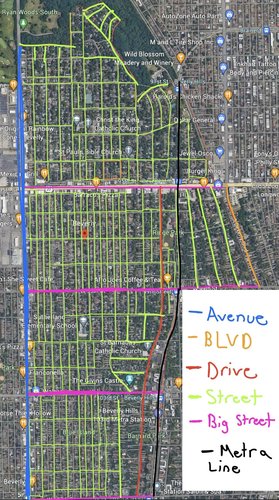
Blue = Avenue, Orange = Boulevard, Red = Drive, Green = Street, Pink = Big Street, Black = Transit Line
There is one avenue in Beverly. That would be Western Avenue (eastern border of Beverly). Avenues have high vehicular capacity and low to moderate speed. Along Western Avenue, at minimum, there are four lanes, and at maximum, there are six lanes. There are many commercial areas/shopping areas along this avenue. This bigger thoroughfare type allows cars easier access to these shopping areas, so there is less congestion or traffic than there would be if there were fewer lanes. This avenue also acts as a connector to other parts of the city, as it runs all the way to the north side of the city.
----- Note: Between most elongated blocks, there is an alley. So, between the long green lines, there is an alley that gives access to parking and where most residents leave their trash.
There is one boulevard in Beverly, which is Beverly Boulevard. This is on the east side of Beverly. This boulevard has only two lanes, and only houses lie along the sides of it. Cars often drive fast down it. It leads directly to Ashland, which is a very busy avenue.
Longwood Drive is one of the more well-known "streets" in Beverly because of its beautiful houses that lie on top of the ridge. Drives are typical of an area that must manage a natural condition, which makes perfect sense considering that Longwood drive winds along the edge of the ridge.
Streets are the most prominent thoroughfare type in Beverly. These streets are 2 lanes and have very low-speed limits, which is very good for a neighborhood that has many children running around. Streets in Beverly provide free parking, which is good for the residents, who mostly have cars. The speed limit is typically 20-25 MPH.
103rd street, 99th street, and 95th street are the bigger streets in Beverly. The speed limit is usually around 30-35 MPH. 95th street is a four-lane street, while 103rd street switches back and forth between two and four lanes. Drivers have to pay for parking along these streets. While 99th street and 103rd street include houses and businesses, 95th street is exclusively commercial.
The Metra line on the east side of Beverly is the line Beverly residents would use to get downtown. There are stops at 107th, 103rd, 99th, 95th, and 91st street.
Savannah Pattern
This is the primary pattern in Beverly. The Savannah pattern has "excellent directional orientation, controllable lot depth, even dispersal of traffic, and efficient use of alleys"(Plater-Zyberk) .
Nantucket Pattern
The Nantucket pattern along the east side of Beverly can be attributed to the wild slope changes along the edge of the ridge.
The low-speed, low-vehicle capacity streets make the residential area of Beverly extremely walkable in the sense that pedestrians do not have to worry much about car traffic. Practically every intersection of streets has a stop sign or stop light. The elongated blocks and safe streets make it enjoyable to walk around Beverly. Even in the northeast area of Beverly, where there are no sidewalks, pedestrians can roam without stress because cars do not have easy access to that area due to the use of cul-de-sacs. Even though it is enjoyable to walk around Beverly, it is not practical for running errands. Yes, busses run along the busier streets of 99th, 103rd, and 95th, but moving along foot for errands is a rarity. Residents rely on their cars for running errands. So the access to parking because of alleys and free street parking allows residents to easily hop in their cars and go to their needed destinations. The grid-like layout, typical of the savannah pattern, makes it easy to navigate along the streets for drivers to get to where they need to go.
The extra lanes on Western Avenue and 95th Street, along with faster speed limits, give residents easy access to commercial locations by car. The capacity of these streets is extremely important in a car-dependent place like Beverly. Because practically everyone is driving to get to where they need to go, if there weren't wider streets like these, it would be mayhem. These streets are not fun for pedestrians to cross, though. The crosswalks for traversing across both sides of the western avenue are very limited. There are parts of western where the sidewalk is very wide, which gives pedestrians enough comfort from the cars. But in the north end of Beverly on Western, the sidewalk is more narrow, so typically, there are fewer pedestrians in this area due to the lack of safety from cars. 95th street has very wide sidewalks and more frequent crosswalks, so it is a more comfortable street for pedestrians to cross. 103rd and 99th street have narrow sidewalks, but because the traffic is not as heavy as it is on Western or 95th, the narrowness does not feel like as big of an issue. Because the main streets are so wide, and overall the commercial areas in Beverly are very limited, traffic will usually never be an issue.
The Nantucket pattern on the east side of Beverly is due to the hilly terrain associated with the ridge. Because of the woods to the east, residents that have to run errands will 100% take cars because they will have to travel west through all the residential areas of Beverly to get to the commercial areas. So, overall, the neighborhood is designed very well for connecting residents by car. But on foot, it is not so easy because the commercial areas are concentrated on busy streets, and these busy streets are not that safe for pedestrians due to the reasons described above.
The main issue that I want to focus on in Beverly is the neighborhood's walkability and access to amenities. Beverly residents depend on their cars to satisfy their daily needs. Over 96% of households in Beverly have access to one or more cars. A car is practically a must in Beverly. There is a ban on the sale of alcohol east of western avenue. Grocery stores only lie upon the western border of Beverly, making daily needs very inaccessible by foot for residents that do not live very close to Western Avenue. Restaurants also primarily lie on Western Avenue, with a few on 95th street. There is no high school in Beverly, meaning young adults must travel out of the neighborhood for school. Walkability and access to amenities are important features for creating relationships in a neighborhood, feeling a sense of belonging in one's neighborhood, and also for sustainability purposes. Cars are bad for the environment, so it is also important to decrease residents’ dependency on cars to lower their carbon footprint. Here are three proposals for making Beverly more walkable and increasing access to amenities in the neighborhood:
Increase Density with Building of Apartments:
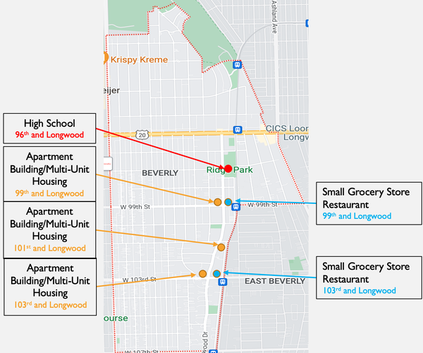
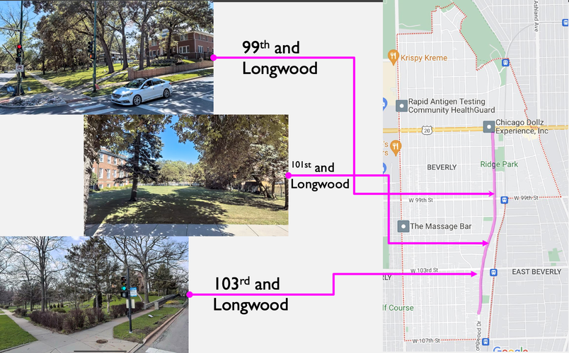
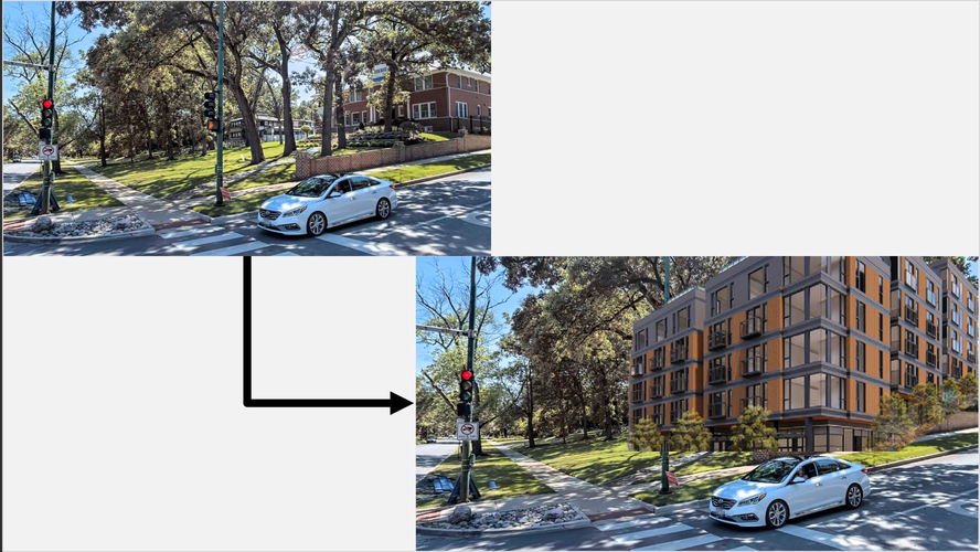
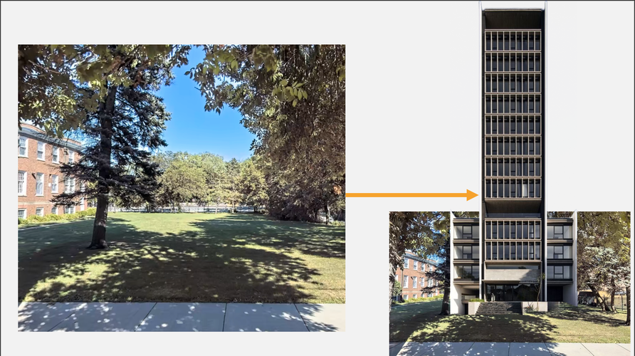
For one thing, at 5.16K people per square mile, Beverly has one of the lowest population densities in the city. 80% of housing in Beverly is single unit/single family. Most neighborhoods with a high number of amenities have a density somewhere between 10-20K people per square mile. This low level of density cannot sustain a higher number of amenities. So the first goal will be to increase Beverly’s population density, as this is the first step to increasing access to amenities. Longwood Drive in Beverly is a street notorious for its huge plots of land. These properties have one house on them that takes up a small portion of the lot, with the rest of the lot being lawn space. Because these plots of land are plenty, and would also lead to the displacement of as low an amount of people as possible, it makes a lot of sense to build apartment buildings or multi-unit housing structures upon Longwood Drive. The intersections of 99th and Longwood and 103rd and Longwood are good spots for apartment buildings because these intersections are in commercial zones. While these commercial zones are somewhat lacking in amenities, an increased level of density could be a first step to growing this commercial zone. This is just a start to increasing the density. Even more apartment buildings could be added to additional lots along Longwood.
Lift the Ban on the Sale of Alcohol:
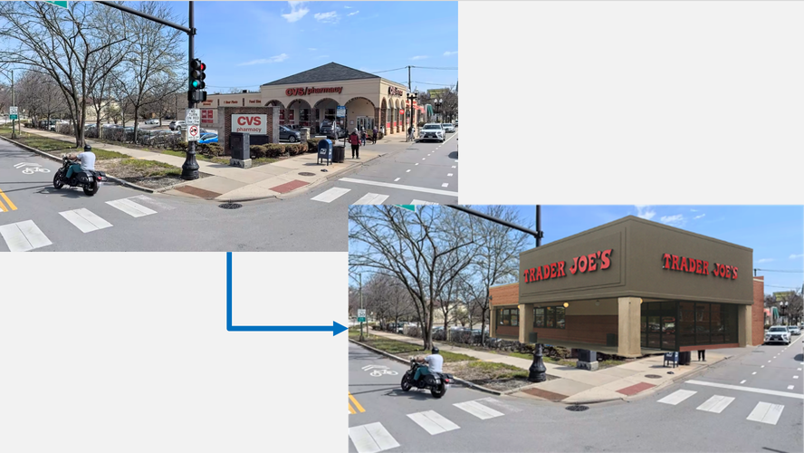
Next, the ban on the sale of alcohol east of Western Avenue needs to be lifted. Almost all of Beverly is covered under this ban. This seems to have played a major role in food service places failing east of Western Avenue. There have been several cafes, such as Ellie’s cafe and Cafe 103, that have closed because they cannot make a large enough profit. At least 25% of restaurant sales come from the sale of alcohol. If this ban is lifted, this will mean there is one less barrier to restaurants being successful. 8% of grocery store sales come from alcohol. The ban on the sale of alcohol means grocery stores are missing out on sales that can be made on Western Avenue, so why would they limit themselves by going east of Western Avenue? Same with the restaurants on Western. That is why the ban on the sale of alcohol must be lifted. Restaurants and grocery stores need to see the commercial areas east of Western Avenue as being real opportunities for them to establish their business. If the ban is lifted, the CVS store that is at 103rd and Longwood could maybe be replaced by a small/mid-sized grocery store, like Trader Joe's. This would allow residents in the southeast area of the neighborhood to have access to groceries within walking distance of their homes. A restaurant could potentially be placed in a very large median next to the railroad tracks. Assuming this restaurant is able to stay for many years because it is now able to sell alcohol, residents that live closer to the east end of the neighborhood will have a new restaurant option close to them. With the increased population, there will be more residents to provide demand for these amenities.
Build a High School in Beverly:
Finally, there needs to be a high school built in Beverly, as currently, there is none. This is a problem in several ways. For one, kids are forced to drive to schools that are outside of the neighborhood because they cannot walk to school. Secondly, schools are primary ways of building strong relationships among community members, so if kids are going to different schools all around the area, when they come back to the neighborhood, their relationships are often limited. Thirdly, schools act similarly to primary uses. Having a high school in Beverly would be good for supporting the other amenities we are trying to bring to the area. Young adults like to get food during lunchtime and also after school, so this would help support local businesses and increase their chances of making a profit. On 96th and Longwood, there is a park district called Ridge Park that would be a great location for a high school. It is in a relatively central location in the neighborhood. This location has 10 acres of land. This is large enough space to build a mid-sized high school. The fieldhouse that is already there can function as the athletics building for students, while also still supporting some community activities. An academic building can be built, as well as a proper field.
Social Mix
Simpson Index Analysis
Race: Beverly has a Simpson score of 2.36 for race. As shown in the table and graph, Beverly's score is around 32% lower than Chicago's score. This is extremely misleading, though. Beverly is one of Chicago's most racially diverse neighborhoods. While Chicago might be diverse as a whole, races are generally segregated into either the north, west, or south side- or, more specifically, into neighborhoods. One would think the score being lower in Beverly means it is less diverse relative to other neighborhoods, but in fact, most neighborhoods are an even larger majority of one race. The two significant races in terms of percentages are white (54%) and black (35%). The remaining 11% of the population is primarily Hispanic but also includes Asian and Others. Compared to East Beverly, we see a very similar score of 2.32; however, the white population makes up 24%, and the black population makes up 60%.
Household Income: The 2.77 Simpson score for household income is much lower than Chicago's score of 4.48 (close to 40% lower). This makes a lot of sense when you consider that Beverly is primarily single-family homes and is relatively homogenous in the household types. Most people own their homes in Beverly. 55% of households in Beverly take in over $100,000.
Age: For age, it looks like Beverly is only marginally less than the city of Chicago. (Beverly is 3.38 and Chicago is 3.52, only 4% less). The very small percent difference might be due to the fact that residents might need to be a little older and have worked more so they can afford to buy a home.
Summary: Beverly is racially diverse compared to most other neighborhoods in Chicago. But compared to the city as a whole, it seems quite less diverse using the Simpson index. Beverly is relatively homogenous when it comes to household income: a majority of households make over 100K. Age is quite similar to that of Chicago.