Overview
Social Mix
Public Space
Amenities
Connections
Final Project
Since its founding in 1886, Edgewater has been defined by its glamorous condominiums which sit on Sheridan Road, right on the coast of beautiful Lake Michigan. Though the neighborhood sits nearly eight miles from the center of Chicago, it is lined with a row of tall condos, each ten to twenty stories in height with sprawling balconies and beautiful lake views. Within a city defined by its industrial nature and cold, harsh weather, Edgewater’s condos construct an oasis from the inhuman city. However, just like the neighborhood, these condos haven’t always been what they seem and despite their luxurious appearances, there is a complex history behind how these condos came to be what they are today.
Edgewater’s modern history began when developer John Lewis Cochran purchased a large swath of land north of the Lakeview community in 1886. The neighborhood originally consisted of a collection of mansions along the lakefront built for wealthy families in Chicago looking for places to stay during the warm summer months. These mansions were the precursor to the construction of the luxurious condos which now sit on the lakefront. The Edgewater neighborhood had many luxurious features such as sidewalks, streetlights, and sewers installed on the streets even before the arrival of residents, however, the one thing it lacked was direct access into the city via rail, which would truly solidify Edgewater as a neighborhood. In order to mitigate for this, Cochran convinced the Chicago, Milwaukee, and St. Paul Railroad to extend their service to Bryn Mawr Avenue, a central thoroughfare of Edgewater.
With the extension of railroads to Edgewater, a plethora of Chicago residents fled into Edgewater prompting the development of the high-density condo buildings seen today along Sheridan Road. The Edgewater Beach Hotel and the Edgewater Beach Apartments were built during this time in a sunrise yellow and sunrise pink color. These two buildings came to define the Edgewater neighborhood and its excessive wealth and glamour. This was assisted by a “Highest and Best Use” zoning ordinance which made high-density apartments part of the building code and prompted the construction of apartment buildings all along the coast. Buildings like these began popping up along the lakefront throughout the early 1920s, and Edgewater began to solidify itself as one of the most luxurious areas in Chicago. As housing prices rose along the lakefront, multi-family apartment buildings and single-family homes started filling in the western areas of the neighborhood. During this time the historic Lakewood-Balmoral district was constructed, along with many of the historic single-family homes in Edgewater Glen.
With the onset of World War II and the continued struggles of the Great Depression, Chicago entered a city-wide housing crisis, and the large mansions and condos which defined the neighborhood were forced to be broken up into small units in order to make room for more residents. This attracted many new ethnic groups to Edgewater and neighboring Uptown. The increase in the density of residents led these once glamorous condos into disrepair, and residents began to grapple with overpopulation and pollution in their living quarters. This decline in glamour and unique character led sociologists at the University of Chicago to declare that Edgewater was in fact not its own community, but a part of Uptown. As soon as the glamour along the lakefront began to deteriorate, the character of Edgewater also achieved a low point.
As the housing shortage eased in the early 1950s, and the country began to work its way out of the Great Depression, developers in Edgewater began constructing multi-unit condos along the lakefront in the locations of old family mansions, however as residents began moving out of the city for the suburbs, Edgewater began to see high levels of vacant residences. At this point, Edgewater was in desperate need of organization, and a strategy to save the neighborhood from vanishing. Because of this, the Edgewater Community Council was formed. This group strove to deal with the problems created by the deteriorating housing that had made the strip of roads adjacent to the lake unsafe and unattractive. This included the demolition of the sunset-yellow Edgewater Beach Hotel which had defined the character of Edgewater only fifty years prior. With the demolition of this building, a new era of Edgewater was born. Immigrant groups continued to flood into the Edgewater area as conditions began to improve. Libraries, museums, and community centers were constructed in the new Edgewater community, and the neighborhood seemed to be on a trajectory to become a great neighborhood once again. In response to this, Edgewater was finally recognized as its own community area by the city of Chicago in 1980.
Today, Edgewater is still a neighborhood defined by its residential buildings with its high-rise condos along the coast, apartment buildings around Broadway, and single-family homes in the western reaches of the neighborhood. The sunset-pink Edgewater Beach apartment building stands as a reminder of the neighborhood's glamourous past as it towers next to other high-rise condos which nowadays house a diverse group of residents. Much like the Edgewater Beach Apartments, Edgewater had to be shifted, repurposed, and rebuilt in order to reach its current status as one of Chicago’s great neighborhoods.
Sources:
Maly, Michael T., and Michael Leachman. “Chapter 7: Rogers Park, Edgewater, Uptown, and Chicago Lawn, Chicago.” Cityscape 4, no. 2 (1998): 131–60. http://www.jstor.org/stable/41486480.
Marciniak, Ed. Reversing Urban Decline: The Winthrop-Kenmore Corridor in the Edgewater and Uptown Communities of Chicago. 1981.
Seilgman, Amanda. “Edgewater.” Encyclopedia of Chicago. http://www.encyclopedia.chicagohistory.org/pages/413.html
Wikipedia contributors, "Edgewater, Chicago," Wikipedia, The Free Encyclopedia, https://en.wikipedia.org/w/index.php?title=Edgewater,_Chicago&oldid=1116565554
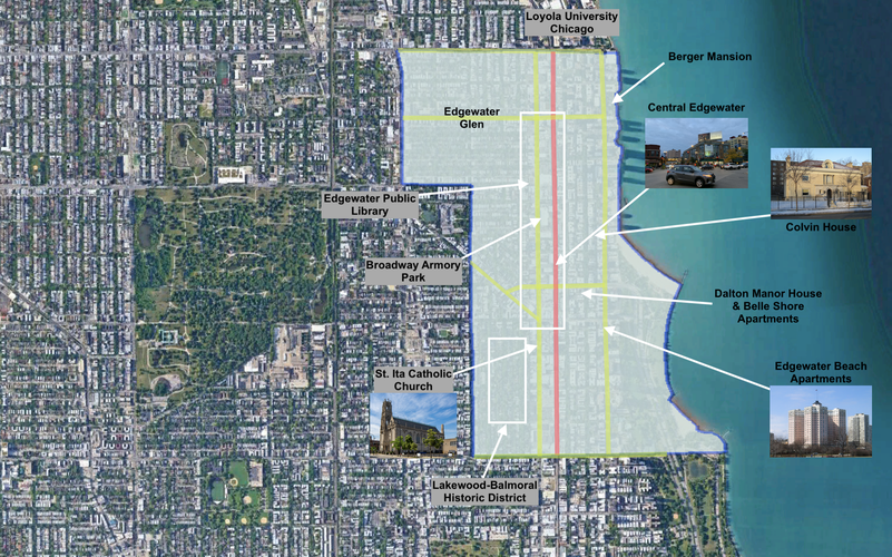
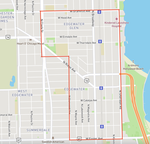
Edgewater is a large neighborhood, both in the sense of geography and
population. The following map is a representation of the neighborhood
boundaries of Edgewater which I determined best defined the extent of the
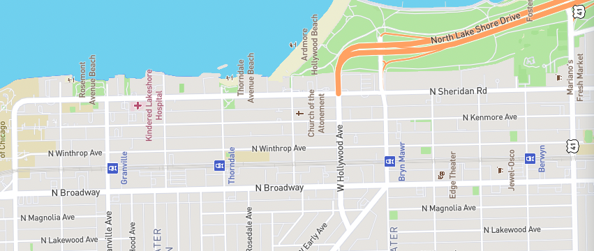
neighborhood. The map is also labeled with major thoroughfares and
transit lines that run through the neighborhood. Using Google Earth, the
area of Edgewater is determined to be 716 acres or 1.12 square miles.
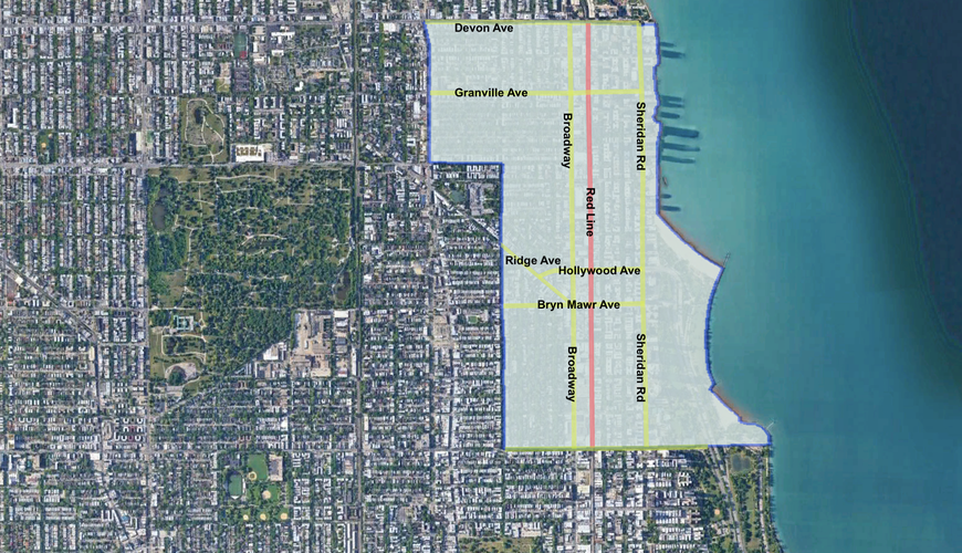
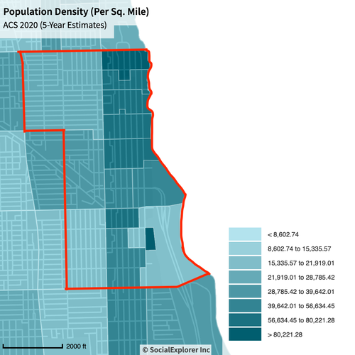
Using socialexplorer.org the population of Edgewater within the above boundaries was determined to be within a range of 40,000 to 45,000 people. The uncertainty of this value is a result of neighborhood boundaries cutting through census blocks, requiring estimation of the population within certain census areas. The following map shows the distribution of population in census blocks around the Edgewater neighborhood with the neighborhood boundaries drawn on top.
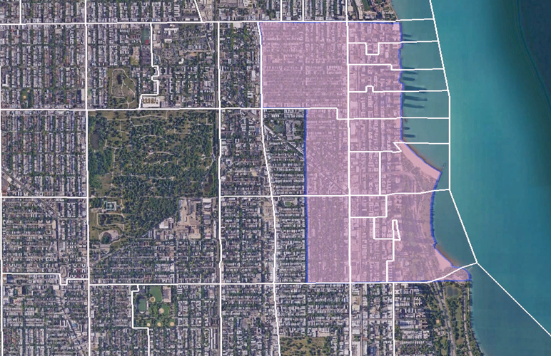
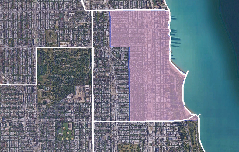
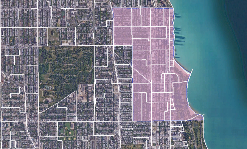
The following maps show various borders overlayed on a map of Edgewater
using Google Earth. The spatial data is provided by the Chicago open
data portal.
Census Tracts overlayed on Neighborhood Boundaries:
Community Area map overlayed on Neighborhood Boundaries:
Ward Map overlayed on Neighborhood Boundaries:
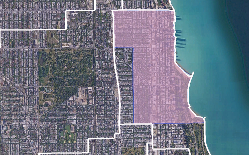
Precinct Map overlayed on Neighborhood Boundaries:
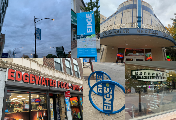
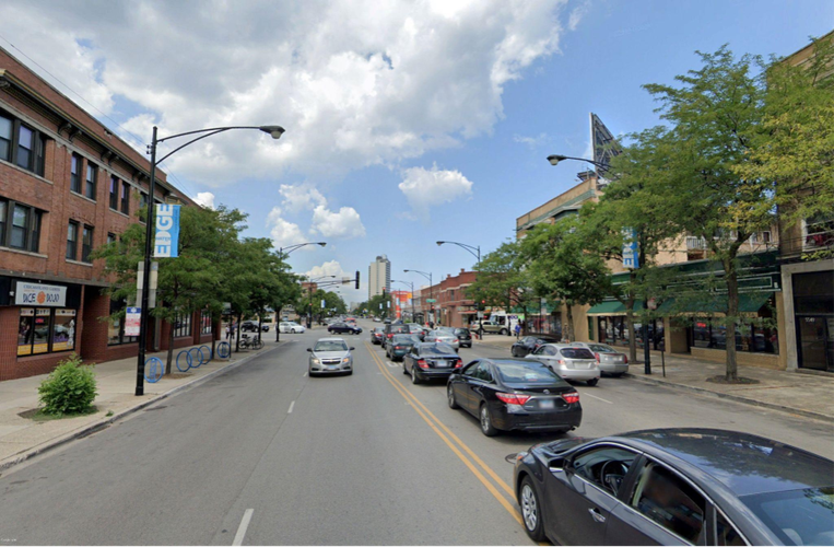
Upon arriving in Edgewater via the red line, a neighborhood identity is quite apparent. The central stop of the Red Line in Edgewater is Bryn Mawr station which stops on the avenue of the same name. Along Bryn Mawr Avenue are custom bike racks with the neighborhood logo, and several businesses with the “Edgewater” in their title. Further west on Broadway, this identity is also apparent with street guides of the neighborhood and signs hanging on light posts with the Edgewater logo. Bryn Mawr and Broadway are two of the main thoroughfares through Edgewater, and both streets house plenty of paraphernalia to suggest a certain level of neighborhood identity. While walking along these streets, visitors and residents are fully aware of what neighborhood they are in. Another element of Edgewater’s identity which helps boost this identity is the strong boundaries the neighborhood has with its surrounding communities. There is a clear distinction between Edgewater and the neighborhood to its south, Uptown, as well as the neighborhood to the southwest, Andersonville. Immediately upon crossing Foster Avenue to the south, street signs begin to read “Uptown,” and the paraphernalia which defined Edgewater disappear. The same goes for Clark Avenue on the southwest side, as the neighborhood abruptly shifts into “Andersonville” upon arriving on Clark, and for Devon Avenue on the North with abrupt shifts to Loyola University’s community area upon crossing over Devon.
Overall, along the main thoroughfares, the identity of Edgewater is very strong. However, this identity is limited, almost completely, to the main thoroughfares such as Bryn Mawr, Broadway, and Devon. Outside of these areas, there is very little infrastructure that suggests a neighborhood identity. There are no signs on lamp posts, very few businesses with Edgewater in the name, and no streets with names concerning their existence within or without the Edgewater community. This is especially pertinent in the northwest area of Edgewater, where there is no sense of a neighborhood border. The northwest corner does not border any large neighborhood area, so unlike when crossing out of the neighborhood from the south, southwest, or north, there is no real sense for when Edgewater begins and ends.
Interestingly, along Sheridan Avenue towards the central and southern portions of the neighborhood, a separate identity seems to override the neighborhood identity shown on streets such as Bryn Mawr, Broadway, and Devon. Many of the high-rise apartment buildings here are named in relation to their proximity to the beach, and a certain identity is built amongst these dwellings separate from the identity of Edgewater. While there are a few Edgewater signs scattered along Sheridan Road, the main characteristic which much of this street shares are property names like “Beach Side Apartments,” “Beach Point Tower,” “Edgewater Beach Apartments,” “Sheridan Lakeside Condos,” and “Shoreline Tower Condos.” This messaging, combined with reduced messaging surrounding the Edgewater neighborhood as a whole create a sub-community within Edgewater’s boundaries creating confusion regarding this area’s involvement in the greater Edgewater neighborhood.
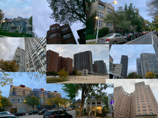
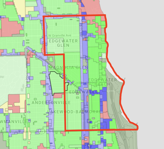
Housing in Edgewater is also varied throughout subsections of the neighborhood, creating a mixed identity within small areas. Locations closer to the beach have their own architectural style, large high-rise condo buildings, balconies, and bright colors. This area is often deemed “Edgewater Beach,” which connects to earlier ideas surrounding the strong connection between this area and its proximity to the lake. To the west of the Edgewater Beach area, between Sheridan and Broadway, much of the housing takes the form of apartment buildings with three to four stories. Many of these buildings share a similar form and image and create another sub-community that is referred to as “Edgewater Proper” given its proximity to the city center and its concentration of population. To the northwest of Edgewater Proper, many of the multi-family apartment buildings become single-family homes, making way for a third subcommunity referred to as “Edgewater Glen.” This area is home to many families, has some of the lowest population densities in the neighborhood, and is one of the farthest areas from the center of Edgewater. These characteristics have similarly separated this area of Edgewater from the rest. This separation of housing types is seen in the diagram below provided by secondcityzoning.org which represents zoning ordinances that separate Edgewater into areas where multi-family homes are supported, townhouse and multi-unity facilities are supported, and where single-family homes are supported. The incongruity between these areas limits the strength of neighborhood identity within Edgewater as each of these areas has developed its own idea of community. Harsh boundaries created by roads have also made each of these communities isolated within themselves, limiting frequent interaction between each sub-community on a regular basis.
Léon Krier, the famed architect, and urban planner known for his creation of the Poundbury community in Dorset, England, was a strong advocate for the separation of the so-called res publica, which consists of public squares, monuments, and parks and the res economica, the areas of commerce, housing, and industry. He believed that in order to spark a sense of community solidarity and to create meaningful public spaces, the res publica should be well-constructed, glamourous, and definitive of community sentiments. These spaces should be long-contemplated and highly adored for their noble usages and appearances. In his eyes, modernist movements had created lazy public spaces, both in the means of construction and appearance, leading many important community areas to be ugly and decrepit. Krier feels nostalgia for the classical architecture of Roman public spaces seen in their public buildings and squares and advocates for the construction of similar edifices within modern cities. The res economica, on the other hand, was less of a contentious topic than the res publica. Houses, factories, and offices are used only by their inhabitants and serve less of the purpose of bringing the entire community together. While there are no sentiments that these buildings should look ugly, there is no auspicious need for these buildings to breed a definitive environment within a community.
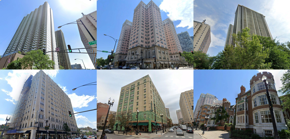
The community of Edgewater nearly inverts the ideas of Krier. As remarked in the historical introduction of Edgewater, it is a community that is by and large defined by its residential buildings. Many of the landmarks and iconic buildings associated with Edgewater that give the neighborhood its defined appearance are the residential buildings spotted along the shore of Lake Michigan. This creates an interesting and paradoxical public domain in the Edgewater community, after all, the defining public features of the neighborhood are primarily private. Below are photos of some of the most historic and defining buildings found along the lakeshore in Edgewater:
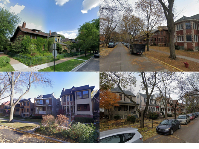
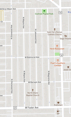
Another defining area of the neighborhood is the Lakewood-Balmoral area, which is a district not defined by its public space or infrastructure, but rather by the historic mansions which line its streets. The area is even listed on the National Register of Historic Places, yet it consists only of private infrastructure. Below are some images of the area which show its distinct style, and its completely residential composition.
While the Sheridan Road lakeside properties and the Lakewood-Balmoral district are defining residential areas of Edgewater, beautiful and intricately designed housing structures are found all over the neighborhood. The majority of streets beyond major thoroughfares such as North Broadway, Bryn Mawr Avenue, Devon Avenue, and Hollywood Avenue are lined almost completely with these beautiful apartment buildings and single-family homes.
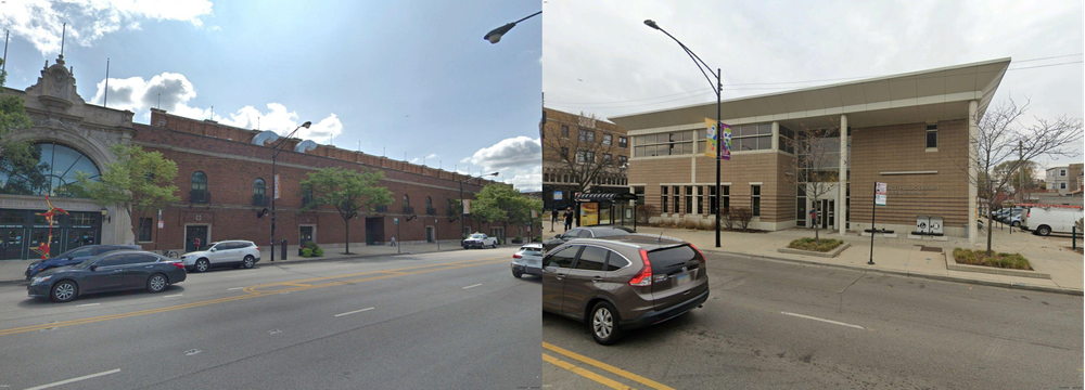
According to Krier’s ideas behind the res publica and the res economica, these private apartment buildings should be overshadowed by the public spaces which compose and connect the community. In the case of Edgewater, this relationship does not necessarily hold up. Looking at distinct public spaces in the neighborhood such as the public library, and a major civic center in the middle of the neighborhood, it is clear that the glamour of the iconic buildings in the neighborhood overshadow these public spaces in terms of appearance. Below are photos of Edgewater’s Broadway Armory Park, a large indoor public park and recreation area constructed in an old military armory building, and the Edgewater Public Library.
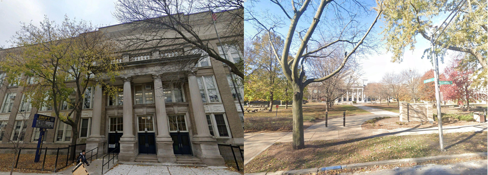
However, this trend does not exist across all of Edgewater’s public areas. Below are photos of two public schools in Edgewater, George B. Swift Elementary School, and Nicholas Senn High School. Housing two of Chicago’s most prestigious high schools, these buildings are beautifully constructed, made in Krier’s ideal. The entrances are clearly demarcated by large columns, and the façades are adorned with artful stone and brick work, giving these important public spaces a special feel. These schools are well-constructed and stand-out amongst other buildings in the neighborhood, proving themselves as a positive example of a well-implemented res publica in the Edgewater neighborhood.
Overall, the res publica in Edgewater is far from Krier’s ideal, but
it still shows glimpses of hope. The neighborhood clearly lacks the
presence of important civic centers as it is limited to the not-so-ideal
Armory Park and public library. To compete with Krier’s ideal there
needs to be further quantity and far better quality buildings that serve
similar purposes as the library and Armory Park. As is seen, the public
schools in the neighborhood are great examples of Krier’s ideal public
spaces, which shows hope for Edgewater. However, it is also important to
note that public spaces like schools are important civic centers, but
they are traditionally limited in their scope of interaction with
students. Even in the best-case scenario, schools are not sufficient
enough locations to handle all of Edgewater’s civic interaction.
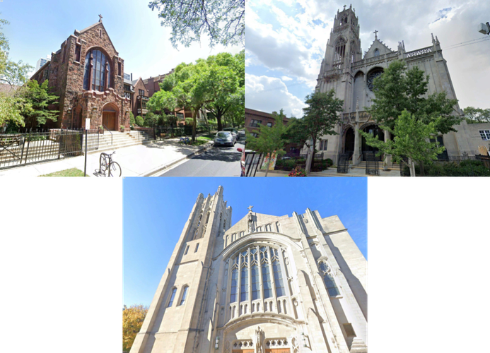
Despite imperfect storefronts along North Broadway and other thoroughfares in Edgewater, there are several “Third Spaces” in Edgewater that are successful in creating a distinctive community image. The Third Spaces that tend to be the most successful in Edgewater are its churches. Three of Edgewater’s most iconic churches, Saint Ita Catholic Church, Episcopal Church of the Atonement, and Saint Gertrude Catholic Church were all built between 1910 and 1930 and stand as some of the most beautiful, and eye catching buildings in Edgewater. Unlike the other Third Spaces described before, these buildings stand out among other elements of the neighborhood, making them important landmarks in the res publica of the Edgewater community.
References:
Krier, Leon. 2009. The Architecture of Community. Washington DC: Island PressDespite this appearance, this is far from the truth. Edgewater actually houses a robust array of local amenities that have the potential to serve a wide variety of the community and give the neighborhood a distinctive feel that many urban neighborhoods seek out. However, with the current orchestration of corporate amenities and local amenities along Edgewater’s major commercial thoroughfares, these local institutions are often overshadowed by the glowing signs and sprawling parking lots which define corporate storefronts.
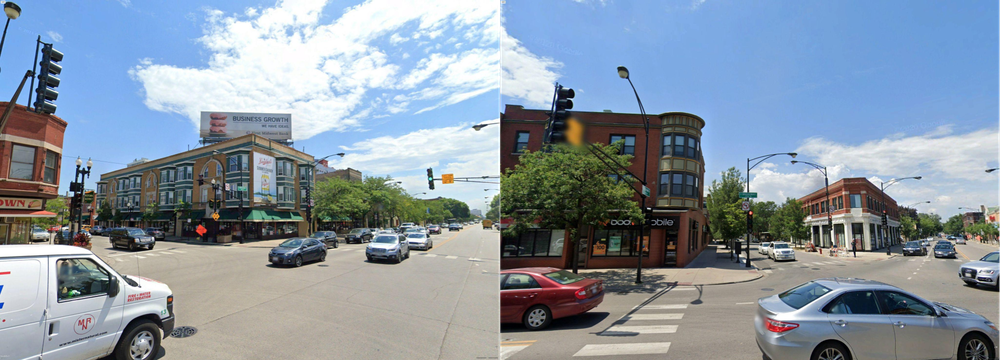
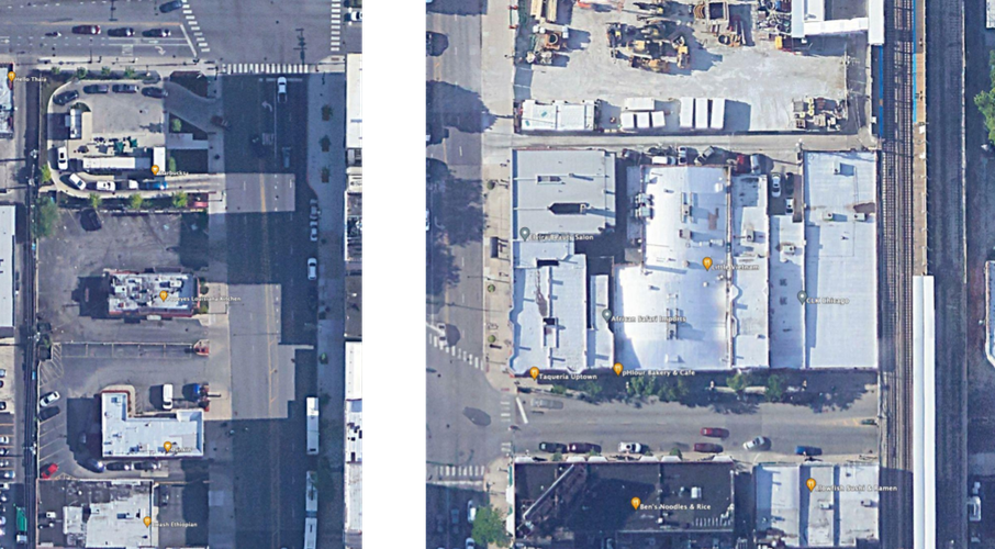
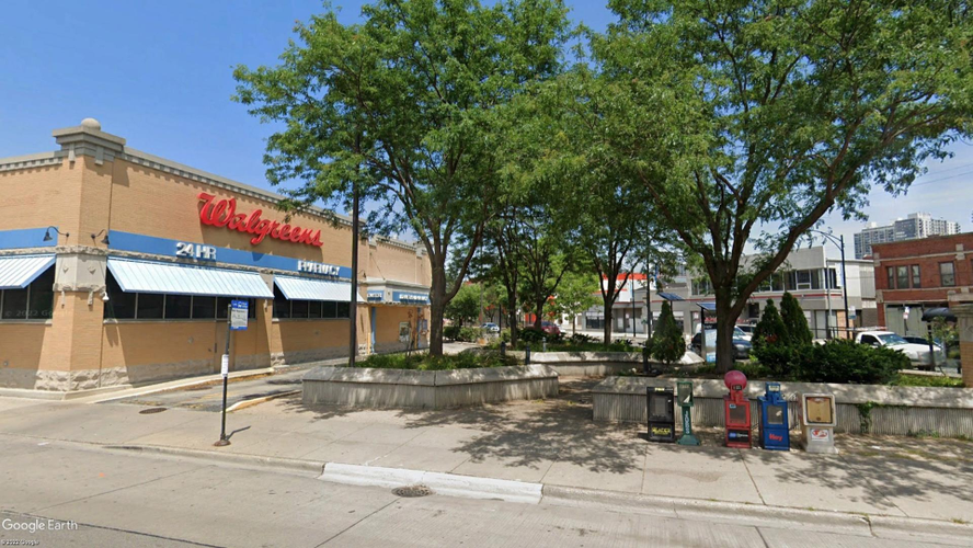
From the street level, the battle between corporate and local amenities is quite obvious. The first example of this battle is the presence of parking lots. Above are a few examples of local shops and amenities next to corporate shops and amenities on the street level. The corporate shops each have large parking lots taking up just as much space, if not more, than the building itself. In order to cater to the large number of customers using cars to commute to these amenities, these corporations purchased wide swaths of land dedicated solely to their customer’s cars. The local shops, on the other hand, are found directly on street level with no visible or private parking lots found around their storefront. Parking lots play many roles in creating unwanted neighborhood dynamics, they are unsightly, they are not environmentally friendly, and they destroy historic buildings and iconic street corners.
Beyond take up space, parking lots outside corporate stores also exclude local shops from good real estate such as busy street corners and intersections along major thoroughfares. The corner store is a classic trope of the great American Main Street because the corner of streets were prime locations for attracting a wide array of customers. Beyond their iconic and distinctive appearance which gives neighborhoods an attractive quality, these corner stores were crucial for ensuring local stores could be successful economically. When these areas are taken by parking lots serving corporate stores, they are stripping precious real estate that could be used more effectively by local stores. Above is a photo of a Walgreens on one of the most important intersections in all of Edgewater, the intersection of Bryn Mawr Avenue and North Broadway.
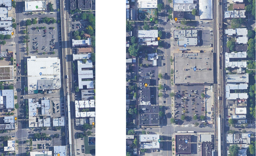
Another example that highlights the battle between the local and the corporate is the sheer size of the corporate entities. Along with their vast parking lots, the sizes of the actual corporate shops and amenities are incredibly large, especially in comparison to the local shops. This creates two problems for local shops, the first being very similar to the problems mentioned earlier regarding parking lots. These massive shops take up a third of entire blocks, and when you add on the parking lot, these corporate shops almost occupy an entire block. The photo above shows the sheer dominance over street blocks that two corporate shops in Edgewater hold.
Through these examples and analyses, it is clear that corporate entities in Edgewater have the winning edge in their battle against local entities. Through their brutish occupation of the neighborhood, they have cast a shadow over the existence of the many small businesses and services found along commercial thoroughfares. Because of this, Edgewater’s central area, North Broadway has taken on an image dominated by corporate forces, but it really doesn’t have to be that way. Corporate forces in Edgewater have successfully bullied many small businesses into the corners of the neighborhood’s commercial district, but it can’t be ignored that Edgewater still has an amazing base of strong, successful small businesses. The neighborhood is not dominated by corporate entities by necessity, but rather by a lack of planning decisions that prioritize small businesses. This shows that Edgewater has the potential to be a neighborhood with a strong presence of local businesses and services, a universal sign of a healthy and successful neighborhood.
All images are taken using Google Earth.
Once again, we must remember that Edgewater is a neighborhood largely defined by its residential features, and due to its interesting mix of diverse residential areas and residential types, its streets have taken on interesting characteristics. Edgewater’s streets house many purposes whether it be commerce, transportation, or housing, yet the streets continually favor residential purposes, creating less-than-ideal characteristics for streets serving other purposes. In order to begin to unpack the elements of Edgewater’s streets that favor residential purposes, we will first look at the block types found around Edgewater and determine how these block types affect Edgewater’s connective abilities.
The area east of North Broadway up to the lake is often referred to as Edgewater beach. It is defined by its many tall apartment buildings, high density, and diverse population. Shown below, this area has elongated blocks in the Savannah pattern with the long side heading north-south. The length of the blocks in this area ranges from 650 feet to 1000 feet, and the width ranges between 400 and 450 feet, making the block especially long and tedious to walk, yet useful for residential development.
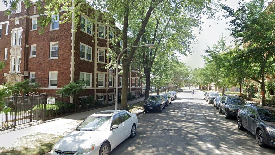
The roads in this area heading east to west are primarily one way roads with widths of around 30 feet. These streets are lined with parallel parked cars, and are mostly low traffic and low speed, making the streets bikeable while not offering designated biking lanes. These streets are all lined with protected sidewalks with green barriers between the pedestrian and the street, allowing for easy pedestrian usage.
East-west running street in Edgewater Beach
The exceptions to this are east-west streets like Bryn Mawr Avenue, Granville Avenue, and Hollywood Avenue, which are all commercial streets that house two way traffic and have a width of around 42 feet. These roads similarly have parallel parked cars along the street, but house higher traffic volume and speed, making the streets less bikeable. The sidewalks are extra wide to account for the store fronts and allow pedestrians easy walking access along these commercial thoroughfares. Given their proximity to residential buildings, and their relatively short block length due to their orientation on the short side of the blocks, these streets are especially effective regions for pedestrian commerce. The number of store fronts and street level businesses on Bryn Mawr Avenue is evidence of this reality.
East-west running Bryn Mawr and Granville Avenues
The roads in this area heading south to north include Kenmore Avenue and Winthrop Avenue, which are almost entirely residential, one way streets with designated biking lanes and parallel parking on each side. These streets are very bikeable and have protected sidewalks on both sides making them very walkable. Additionally between these roads there are rear lanes where residents can access storage spaces, garages, trash disposal, and additional parking. These constitute some of the most beautiful and well maintained roads in Edgewater given their pedestrian friendly design, enveloping foliage, and intricate architecture. This once again shows the extra focus placed on residential areas in Edgewater.
North-south running Kenmore and Winthrop Avenues
Sheridan Road is a boulevard running north to south on the eastern edge of the neighborhood and runs between the many high rise apartments along the lake shore. This boulevard is two way and has high traffic volume and speeds and is one of the busiest thoroughfares in Edgewater despite its location within a highly residential area. Sheridan Road has a width of around 40 feet, and because many apartment complexes along the road have their own parking lots in the back of the lot or underground, there is no street parking along the road. The combination of a wide street with little to no obstacles along the way leads the traffic to move especially fast and dangerously. On top of this, Sheridan Road’s sidewalk has a disproportionately small sidewalk size given the size of the road. The sidewalk is protected by a strip of green space, but the walking space is small and, in many areas, overrun. This makes for a very poor pedestrian experience along this boulevard, although, given the boulevard’s lack of commercial options, pedestrians is not of the utmost importance on this thoroughfare.
North-south running Sheridan Road
Overall, the Edgewater Beach area needs improvement when it comes to connectivity. Its long block size makes it hard for residents to easily walk from their residence to the main commercial hub of the neighborhood, North Broadway, which sits on the western border of the Edgewater Beach area. As mentioned earlier, many blocks are around 650 to 1000 feet long, which is far from the ideal 300-400 feet long blocks for local streets. For residents who live along Sheridan Road, their walk to North Broadway will be very tedious, dangerous, and unpleasant, limiting their connection to the rest of the Edgewater neighborhood. Further, while Bryn Mawr Avenue is a good example of a street successfully housing commerce, walkability, and pedestrian enjoyment, there is a lack of streets built like this in the Edgewater Beach area. Streets like Bryn Mawr Avenue not only provide Edgewater Beach residents with commercial offerings beyond North Broadway but serve as pathways for residents to other parts of the neighborhood. Bryn Mawr Avenue is an amazing example of what a street like this can look like, but Edgewater Beach lacks a sufficient quantity. In their current orientation, Edgewater Beach’s thoroughfares are fitted to best accommodate residential traffic, and people traveling to or from their houses. However, it lacks in its ability to connect residents with the commerce and life happening in parts of the neighborhood farther to the west. Further development to accommodate pedestrians connecting the central areas of Edgewater and the Eastern areas is crucial to creating a more successful and connected neighborhood.
All of the thoroughfares in Lakewood-Balmoral are low speed, low volume, one way r0ads with widths around 30 feet. These roads have parallel parking on each side of the street, protected sidewalks on each side, but no protected bike lanes, although the low traffic make biking achievable on these streets. Like Edgewater Beach, the north-south roads have rear lanes running between them for residents to access the back portion of their house. Each of these streets are safe for pedestrians and lined with trees and historic residences creating a rich pedestrian experience. However, streets in this area run into the same problems as Edgewater Beach when it comes to connectivity. The block length is too long, and access of the North Broadway area is a long and tedious affair for residents of Lakewood-Balmoral.
North-south running Lakewood, Magnolia, and Catalpa Avenues
Edgewater Glen is another small section of Edgewater found in the northwest portion of the neighborhood, west of North Broadway and north of Thorndale Avenue. This area is highly residential with primarily single-family homes, making for a similar street atmosphere to Lakewood-Balmoral. The streets in this area are in the Savannah pattern with elongated blocks, however, because of the different orientations of blocks, there is a lack of organization of thoroughfares in the area.
East-west running Rosemont and Hood Avenues, and North-south running Greenview Avenue
Street discontinuties at Thome and Wayne Avenues
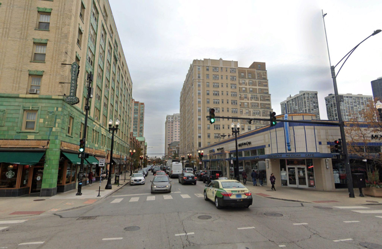
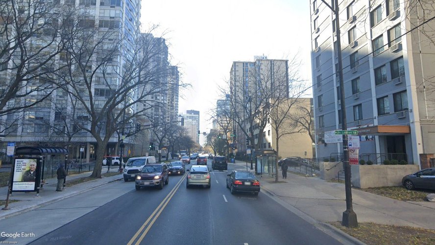
North Broadway is the main boulevard in Edgewater and runs north to south through the middle of the neighborhood. While not necessarily a section of the neighborhood like the past examples shown, it is the central commercial and community location in the neighborhood, making its street layout crucially important. North Broadway is lined with services, stores, parking lots, parks, and residential buildings, making it a street that serves many purposes and methods of transportation. It is also the physical demarcation that separates the west side and east side of the neighborhood across which there are many demographic differences, making its ability to connect people especially important for the creation of neighborhood solidarity.
Three images of North Broadway highlighting its wide, car-centric design
Edgewater’s most signature building, the pale pink Edgewater Beach Apartments, tells a story about the neighborhood’s rich past. During the early twentieth century, the peak of Chicago’s industrial period, the Edgewater Beach Apartment building was the defining feature of the neighborhood. Among a gray city filled with concrete, steel, and smog, stood the Edgewater Beach Apartments, a glimmer of beauty and luxury in the dark urban environment. On the doorstep of the building were sandy beaches, and the bright blue waters of Lake Michigan; Edgewater was the place to be. It was a retreat from the roughness of the city for lucky Chicagoans and a home for the luckiest. Overall, it was more than just a residential neighborhood, it was a destination. Edgewater has been a place of tumultuous change in the time between the early twentieth century and the present, a time period where the neighborhood has undergone a complete change in its image. The pink Edgewater Beach Apartments along the shore of the lake and the stately mansions throughout the Lakewood-Balmoral district stand as a testament to Edgewater’s luxurious past, yet the otherworldly appeal Edgewater once boasted has changed slowly changed to indifference.
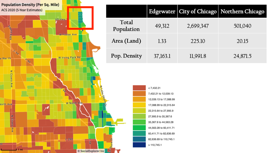
Living in the shadow of its past, Edgewater is now but another north-side neighborhood with quiet streets and all-American storefronts. However, if nothing else, Edgewater’s history stands as evidence that it has the ability to be one of Chicago’s most unique and magical neighborhoods, even today. The premise of this project is to bring back the Edgewater that excited and enticed so many people and to create an environment as unique as the pale pink Edgewater Beach Apartments, a symbol of paradise within an urban jungle. This project will build on the remnants of the old Edgewater that still remain and use these strengths to make the neighborhood the destination it once was. Through the recommendations of this project, Edgewater will become a place where people want to live and spend their time, and where people from all over Chicago will come again and again. Edgewater may have quieted down in its last 100 years of existence, but the neighborhood it once was has not yet vanished and will provide a strong basis for the existence of this neighborhood in the twenty-first century.By many standards, Edgewater has amazing potential to be a very strong Urban neighborhood. The first element of potential concerns the neighborhood’s uncharacteristic population density, which is actually one of the highest of any area in Chicago despite its distance from the city’s center. Edgewater’s density is measured at 37,163 residents per square mile, and as seen in the figure below, this is far denser than the city of Chicago as a whole, as well as the northern region of Chicago. The figure below also shows how several census tracts in Edgewater (the area within the red square) stand out among other north-side regions and are grouped within the same range of population densities as Lincoln Park, Streeterville, River North, and other high-density regions found close to Chicago’s downtown. It becomes clear that Edgewater is a hidden gem of Chicago when it comes to population density, as this neighborhood lies far from the regions of the city that are traditionally dense.
Figure 1: Population Density (per sq. mile). Data provided by socialexplorer.com/
This density is very crucial to Edgewater’s potential as a neighborhood. Jane Jacobs notes that one of the key factors to a successful neighborhood is the density that Edgewater exhibits. Jacobs’ writing suggests that density creates a chain reaction of important neighborhood features such as safety, diversity, equity, reduced car dependency, and neighborhood resilience. This proves that Edgewater’s density is a strong indicator of its potential to be a successful neighborhood.
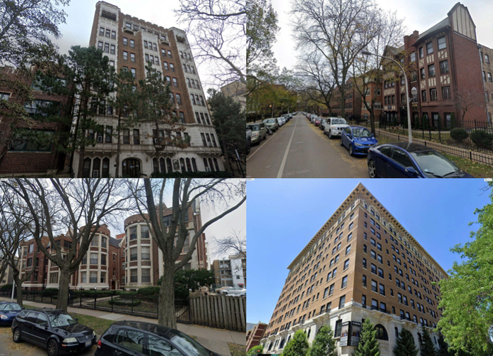
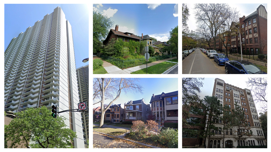
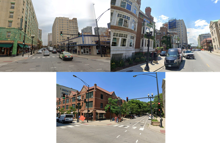
Accompanying this population density are similarly strong housing, economic, and racial diversities. Edgewater exhibits a wide range of housing types from high rises accommodating 50 residents or more, to single-family homes with nearly everything in between. The figure below shows images taken from Google Earth of this variety of housing.
Figure 2: Housing Diversity in Edgewater. Image source: Google Earth.
This diversity attracts a wide range of family types to the neighborhood, as well as economic classes and races given the wide variety of accommodations and housing prices available in the vicinity. The benefits of diversity to a neighborhood are countless, including increased economic vitality, equitable distribution of resources, the elimination of concentrated poverty, and many more. Diversity is an undeniably important aspect of a healthy urban environment, and Edgewater’s strength in this area further solidifies the neighborhood’s prospect as a strong neighborhood.
Figure 3: Racial Composition. Data provided by socialexplorer.com/
Edgewater’s demographic strengths are some of the most unique and important aspects of the neighborhood, however, the neighborhood’s strengths extend beyond just demography. One of Edgewater’s great strengths is Bryn Mawr Avenue, an east-to-west running street in the neighborhood that exemplifies what a good commercial corridor in Edgewater could realistically look like.
Figure 4: Bryn Mawr Avenue streetscape. Image source: Google Earth.
Bryn Mawr Avenue is the oldest commercial street in Edgewater and has served as the center of the community since its founding. This street houses both local businesses and high-density developments, it is home to historic buildings and architecture, and it is relatively friendly to pedestrians in terms of safety and enjoyment. For these reasons, this street is a great example of what commercial thoroughfares in Edgewater could look like if more investment was placed in creating meaningful thoroughfares. This street was a topic of the Red and Purple Line modernization project bolstered by various city agencies, with a special focus on the preservation of this street as a historic pedestrian thoroughfare. Regulations kept historic buildings from being torn down, from new developments having setbacks, and from the strong mixed-use nature of the street from being compromised by zoning laws. These regulations were incredibly helpful in preserving this important public space and show that Edgewater has the regulatory capacity and desire to have successful pedestrian streets like Bryn Mawr Avenue.
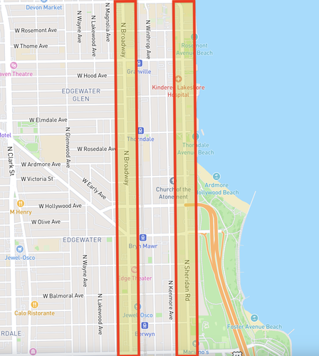
Edgewater’s main weaknesses as a neighborhood revolve around its main boulevards, North Broadway Avenue, a commercial boulevard passing through the center of the neighborhood, and Sheridan Road, a residential boulevard passing through the eastern edge of the neighborhood. These streets are both in central areas of Edgewater: North Broadway is situated in the social center, and Sheridan is situated in the population center.
Figure 5: North Broadway Avenue and Sheridan Road
However, despite this, these boulevards are completely fixated on using the street solely as a means of transportation rather than a public space. These streets account for many of the problems in the Edgewater neighborhood.
More specifically, North Broadway’s problems stem from a major lack of walkability. This boulevard is the centerpiece of the Edgewater, physically, commercially, and socially. It not only runs through the center of the neighborhood, but it is also the place where many Edgewater residents go shopping, use services, and engage in other consumer activities. Despite this, Broadway does not feel like a public space. It is not a place where one can linger, mingle with fellow residents, or spend leisure time. This road is completely dominated by cars whether that be manifested in the lack of safe crosswalks, the orientation of businesses away from the street, or the sheer number of parking lots along the boulevard. Broadway is unsafe, unsightly, and loud and incentivizes the use of cars, corporate businesses, and amenities based outside the neighborhood. This misuse of this central space detracts greatly from Edgewater’s ability to connect residents and support a local economy and is one of the major problems this neighborhood faces.
Figure 6: North Broadway Avenue streetscape. Image source: Google Earth
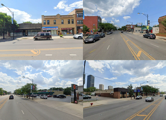
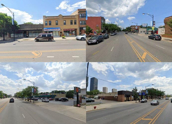
One of the main outcomes of having a street like North Broadway Avenue is the overpowering of corporations over small businesses. Broadway is scattered with corporate businesses like Jewel-Osco, Whole Foods, L.A. Fitness, and Mcdonalds, all of which provide necessary services. However, the problem with these services is not their mere presence, but how they occupy North Broadway. The juxtaposition of corporations to small businesses is shown in the diagrams below, with the local businesses on the left side, and the corporate businesses on the right.
Figures 7-11: Broadway's local businesses in conversation with Broadway's corporate businesses. Image source: Google Earth
Along Broadway, corporate businesses occupy far more space, detract from the streetscape through building setbacks, and waste land through the use of parking lots. On the contrary, small businesses along this corridor take up far less space and are normally situated in mixed-use developments, housing multiple stores and amenities, and historic buildings which contribute to the character of the street.
This comparison shows that corporations are taking up far more space than they should be afforded, and they are undermining the presence of important small businesses which provide more to the neighborhood in both an economic and social sense. The high-speed car traffic along Broadway contributes to the success of corporate businesses as car traffic will be more inclined to utilize businesses with more robust car infrastructure. The presence of, and the contribution to these corporate businesses along Broadway is something inhibiting Edgewater’s central area from achieving the environment that it needs to truly function as a public space.
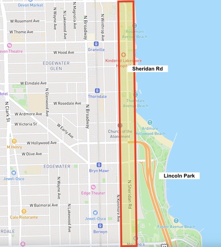
Sheridan Road suffers from similar issues as Broadway, as it is completely unable to act as a public space given its car-centric design. Separately from Broadway, Sheridan Road is situated in the residential center of the Edgewater neighborhood, but this doesn’t make the walkability of the boulevard any less important. First, high car speeds, a lack of crosswalks, and underdeveloped sidewalks outside residential areas prevent residents from venturing from their residences on foot, stopping foot traffic in the neighborhood from its source.
Figure 12: Sheridan Road streetscape. Image source: Google Earth.
Additionally, Sheridan Road is a major impediment to Edgewater residents looking to access Lincoln Park, one of Chicago’s greatest lake-front parks found in the southeast corner of Edgewater. This is the biggest and most highly used park in Edgewater, yet Sheridan Road acts as a barrier to this important resource.
Figure 13: Map visualization of the spatial relationship between Sheridan Road and Lincoln Park
Further, this street, despite its central location within the neighborhood’s population serves residential purposes almost exclusively. This is primarily due to zoning which keeps many portions of the street residential-only, keeping this busy district, a place where multi-use development would thrive, from non-residential developments.
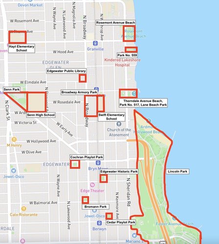
Edgewater’s boulevards are unable to foster pedestrian-friendly public spaces, but the need for these public spaces along Edgewater’s boulevards only exemplifies the need for more fully devoted public spaces in the neighborhood. The map below shows how few public spaces are spread throughout Edgewater. The public spaces included in this diagram are primarily public parks which are fully public spaces, but some of the spaces shown are high schools or elementary schools which are, traditionally, quasi-public spaces only available for use by the broader public on special occasions.
Figure 14: Diagram of public and quasi-public spaces in Edgewater.
The area of the neighborhood made up of parks and public spaces is quite small, and there are areas such as Edgewater Glen and Lakewood-Balmoral that are almost completely unserved by the area’s parks and public spaces. However, not only the quantity of parks and public spaces is concerning, but also the concentration of park space on the periphery of the neighborhood in Lincoln Park, far from other potential public spaces, resources, and amenities. This park is separated from the central area of the neighborhood, and as mentioned previously, getting to this park also requires crossing Sheridan Road and passing under Lake Shore Drive making travel to this park treacherous and unpleasant.
The final weakness of the neighborhood that I would like to speak to
regards the number of Edgewater residents who travel outside of the
neighborhood for work. Because of Edgewater’s location so close to the
Red and Purple lines, the most highly used rapid transit lines in
Chicago, and the beginning of Lake Shore Drive, Edgewater is a great
location for commuters who work in other parts of Chicago to reside. According to The Chicago Metropolitan Area for Planning, 31.5% of Edgewater residents work outside of Chicago, 22.0% work in the loop, another 50% work in other areas of the city, and only 3.5% of residents both live and work in the neighborhood. This means that during the day, 96.5% of the work force that does not work from home is leaving the neighborhood, leaving the streets, shops, restaurants, and parks empty for almost the entire day. In order to have safe, economically healthy, and enjoyable streets, one of the prerequisites is accommodating usage at all times of day, something that Edgewater’s streets cannot deliver given the sheer number of workers who leave the area every day. Edgewater’s streets are a major problem for the neighborhood, as mentioned earlier, but without consolidating the workforce into the neighborhood, even successfully designed streets wouldn’t reach their full potential. Successfully designed streets need residents to use them at all times of day before they can truly be successful public spaces.
My interventions in Edgewater will attempt to take better advantage of the strong natural features of Edgewater detailed at the beginning of this piece. Further utilizing the uncharacteristic density and diversity which is so unique to Edgewater will naturally begin to address the neighborhood’s biggest weaknesses. The general theme of my interventions will surround the creation of public spaces along important boulevards to curate pedestrian spaces for community members to convene, new areas for small businesses to open storefronts, and places for employers to house workspaces. Edgewater is a dense area, something that makes it stand out among other neighborhoods in Chicago, and something that gives it the necessary resources to have a healthy, self-sustaining economy and dynamic public spaces. Therefore, the thematic framework of my interventions will surround the development of spaces in Edgewater that will allow residents to stay in the neighborhood during all times of the day. These interventions will also attempt to reach beyond the neighborhood and attract residents from various other places in the city to make Edgewater a destination.
My first set of interventions will concern North Broadway Avenue and the conversion of this boulevard into a pedestrian-friendly public space. The following is a diagram created using an online tool called Streetmix which documents the distribution of space to cars, pedestrians, and other features of the street. The dimensions are all to scale using measurements taken from Google Maps.
Figure 15: To-scale diagram of North Broadway's street dimensions. Created using Streetmix.
The first step to making this boulevard more pedestrian-friendly will be slowing the speed limit from 35 miles per hour to 25 miles per hour and substituting stop signs at each intersection for stop lights. Traffic moves too fast along this boulevard, which is one of the primary concerns for pedestrian usage of this street. Slowing the speed limit by 10 miles per hour will mitigate some of these concerns, and the placement of stop signs instead of stop lights will force drivers to be more attentive to traffic, and traverse intersections at slower speeds. In order to further incentivize slower speeds, and to make the street more compatible with the use of stop signs as a means to regulate intersections, I propose for North Broadway’s traffic to be limited to one lane in each direction and for street parking to be removed from the street. Consolidating traffic to one lane will further slow down cars and allow for the usage of stop signs in place of stop lights. Removing street parking will allow for the extra two lanes of traffic to be converted into a protected bike lane, outdoor dining space, and extra room for pedestrians. To accompany these new additions to the pedestrian experience, I also propose the addition of sidewalk extensions at each intersection along North Broadway and the addition of more defined crosswalks. Sidewalk extensions, shown below, are devices that have already been implemented in parts of Edgewater and add significantly to pedestrian safety by shortening the length of crossings and providing pedestrians with greater sightlines. These three proposals together will add to the pedestrian experience by making the street safer, and more oriented towards people, not cars.
Figure 16: Visual depiction of curb extenstions. Image source: natco.org/
It will also be important to solidify North Broadway as a place where residents can linger, relax, and mingle, as opposed to a place that is completely transitory. To promote the use of this space in this way, I propose the addition of a grassy median between the two lanes of traffic with bushes, plants, and trees. Further, I would like to add more foliage to the sidewalks as well as benches, and street lamps. These features will further enclose the pedestrian and allow them to linger night and day as if North Broadway was a public plaza or park. Given these changes to the street, the final design will look like the following diagram.
Figure 17: To-scale diagram of North Broadway's street dimensions following interventions. Created using Streetmix.
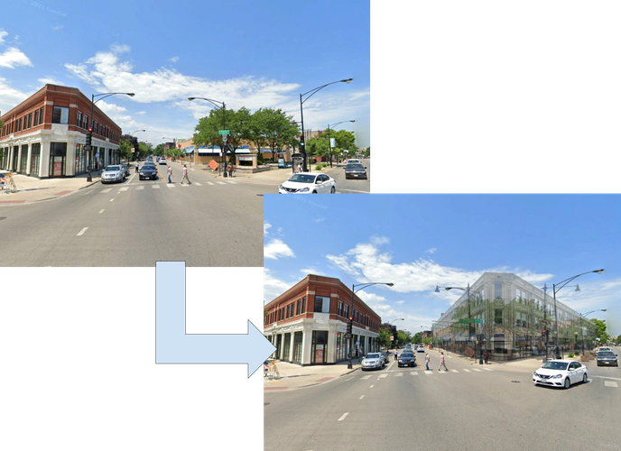
Beyond the design of the street, North Broadway needs to start building around the presence of corporations. These proposed street designs will accommodate more pedestrian traffic, but with the current array of car-centered businesses and amenities, the increased pedestrian traffic will not be able to build a strong relationship with the businesses along the boulevard. The first step in making a more pedestrian-friendly commercial environment will be writing policy that requires developments to build up to the street level. There is a place for corporations along North Broadway as many of them provide services that members of the Edgewater community need, but these corporations must be forced to orient their business toward pedestrians given the new changes to Edgewater’s pedestrian design.
Figure 18: Potential revision in North Broadway's streetscape at the intersection of N. Broadway Ave and Bryn Mawr Ave. Image source: Google Earth
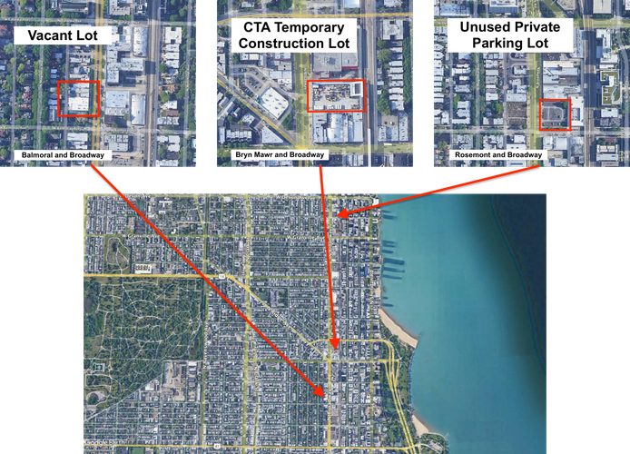
Building setbacks force pedestrians to walk farther, and through undesirable locations, like parking lots making them incompatible with a street like my proposed version of North Broadway. Policy should not only require developments to build up to street level but should also incentivize developers to create mixed-use spaces. I propose the creation of tax incentives and directed government loans to developers proposing to build low-cost, high-density, multiuse buildings along the North Broadway commercial corridor. Building spaces like these accomplishes many goals, including an increased presence in small businesses, more traffic on the street at all times of day, and a healthy local economy, to name a few. Developers must be incentivized to build places that can accommodate a wide variety of needs, from offices to storefronts, to public spaces in order to preserve the health of North Broadway. These multiuse developments will be placed in vacant lots, abandoned buildings, and parking lots in order to begin building around the corporations which now overpower North Broadway. Below are three prime locations for these proposed multi-use developments.
Figure 19: Diagram documenting three areas for potential mixed-use developments along N. Broadway Ave. Image source: Google Earth
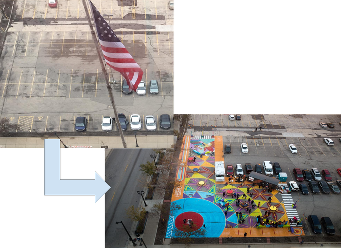
In order to mitigate for the lost space created by private parking lots, and to begin building more devoted public spaces in Edgewater, I propose the collaboration of government and private businesses to create multi-use parking lots and public spaces in existing parking lots. The following pictures show a project undertaken in the city of Milwaukee to convert two public parking lots into dynamic public spaces.
Figure 20: An example of how to convert parking lots to public spaces. Image source: Project for Public Space (pps.org)
These two important lots which had long been dead space were handed to the residents of the city to curate a public space. The pavement was painted over, seating was added, a stage was erected, and events started to be held in these previously dead areas. Through government intervention, the same can be done in private parking lots along Broadway, and these areas, which sit empty for many commercial and non-commercial hours in a day, can be activated as public spaces. Farmers markets, community concerts, fairs, and leisure time can all find a place in dynamic public spaces such as these.
The second set of interventions I propose will center around Sheridan road, the other major boulevard in the neighborhood lacking in its ability to function as a public space. Below is a similar diagram as was created for North Broadway.
Figure 21: To-scale diagram of Sheridan Road's street dimensions. Created using Streetmix.
My interventions on this street will look very similar to my interventions on North Broadway. In regard to street design, I propose lowering the speed limit to 25 miles per hour, replacing stop lights with stop signs, adding curb extensions, further delineating crosswalks, constructing benches on the sidewalk, and adding a grassy median, exactly the same as my interventions on North Broadway. I also propose to similarly limit traffic to one lane in each direction and replace the extra lane with a protected bike lane. The motivations behind these changes are similar to the motivations behind the changes on North Broadway, to make a space where pedestrians are safe, and a space that better resembles a public park or plaza than it does a road. Given that Sheridan road is the center of population density in the neighborhood, and the doorstep to many high-density developments, a pedestrian-centered boulevard is especially important to make sure residents are inclined to spend time in public spaces. These changes will attract the many people living in this area to spend more time on the street engaging with their community and fellow residents. This will also make this a thoroughfare that is easier to cross in order to reach the highly important Lincoln Park. The following is a diagram of the street following these improvements.
Figure 22: To-scale diagram of Sheridan Road's street dimensions following interventions. Created using Streetmix.
Similar to North Broadway, Sheridan Road is in need of an intervention in response to the overpowering of parking lots and other forms of automobile infrastructure. To address the parking lots found adjacent to many residential developments along Sheridan road, I will propose a new method for converting these dead, car-centric spaces into public spaces. Instead of converting parking lots into dynamic public spaces like was proposed along Broadway, I propose to convert parking lots into natural areas. This will be achieved through the government funding of buried parking lots, and the construction of public spaces above buried lots. These lots will consist of a layer of underground parking connected to residential developments, and parks built on the street level, similar to Park No. 517 found on Sheridan Road shown below. This will add appropriate public space to this highly residential area and begin to mitigate for the detriments of having parking lots on the street level while still allowing parking infrastructure to remain in the area.
Figure 23: Park no. 517 at the intersection of W. Thorndale Ave and Sheridan Rd. Image source: Google Earth
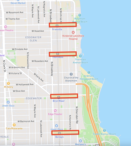
The third set of interventions will concern the streets which run east to west between Sheridan and North Broadway. As they stand, these roads are very quiet, completely residential, and serve as poor connecting streets between the Edgewater Beach area and central Edgewater.
Figure 24: Important connecting roads between N. Broadway and Sheridan: W. Granville Ave, W. Thorndale Ave, W. Bryn Mawr Ave, and W. Berwyn Ave.
This is troubling, because many of the resources in Edgewater lie in the central portion of the neighborhood, while much of the population lives in the Edgewater Beach area, making an easily traversable, and pleasant connection between these two areas very necessary for incentivizing pedestrian usage of North Broadway. For residents from the western portions of the neighborhoods, an effective connection between Broadway and Sheridan is also necessary to access important lakefront parks like Lincoln Park. For this reason, I propose a redesign of these streets to create better connections between the Edgewater Beach area and the rest of the neighborhood. These improved connections will create corridors that are safe and enjoyable to incentivize the mingling of residents from all parts of the neighborhood.
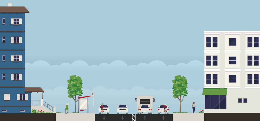
Specific interventions along this street will include a complete pedestrianization of Bryn Mawr Avenue. Bryn Mawr Avenue is already a very successful pedestrian zone, something that has been remarked upon already in this piece, however, it has the potential to be an even more powerful and unique public space that attracts visitors from all over Chicago. This is especially true because of Bryn Mawr Avenue’s orientation along the Red Line, other central bus lines, and Lake Shore Drive, providing easy access to residents of Edgewater and the greater Chicago area alike. Below is a diagram of the current layout of Bryn Mawr Avenue.
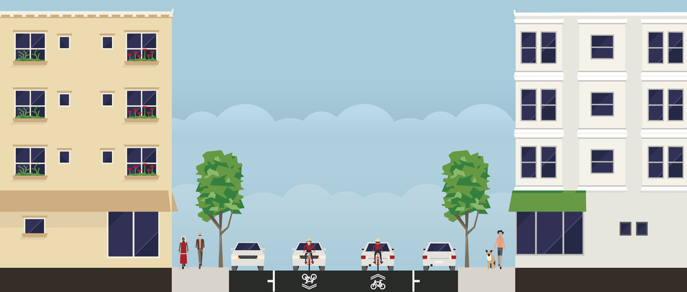
Figure 25: To-scale diagram of Bryn Mawr Avenue's street dimensions. Created using Streetmix.
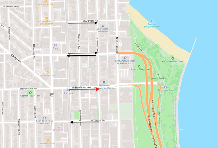
My proposal begins by making the street one way running towards the west. This will reduce traffic and lower speeds, making this important thoroughfare, even more, pedestrian-friendly, and will have little disruption on the automobile patterns of the neighborhood. Currently, Bryn Mawr is used as a means to access Lake Shore Drive, but Hollywood Avenue, one block north of Bryn Mawr, is a four-lane road that accesses Lake Shore Drive directly, making the need for Bryn Mawr to be a two-way street for this reason redundant. Catalpa Avenue just to the south of Bryn Mawr runs one way to the east, making the need for Bryn Mawr to be one-way obsolete.
Figure 26: Traffic flow in central Edgewater. Exisiting conditions (black), revised conditions (red).
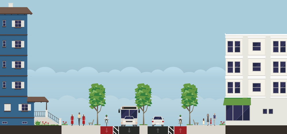
I also propose lowering the speed limit to 15 miles per hour, removing street parking, and using the extra three lanes of traffic as an extended pedestrian and biking zone. The resulting street will be a place where cars have access, but pedestrians and bikes consistently have the right of way. This will make Bryn Mawr a safer and more effective commercial avenue, but also a true public space. Extended pedestrian areas will make room for street vendors, performers, and community events. The reduced reliance on this street will allow it to intermittently be shut down to host block parties and festivals, and other neighborhood-wide events. The resulting streetscape will look like some of the following streetscapes found in cities around the world.
Figure 27: Three pedestrianized streets found in cities around the world. Image source: Project for Public Spaces (pps.org)
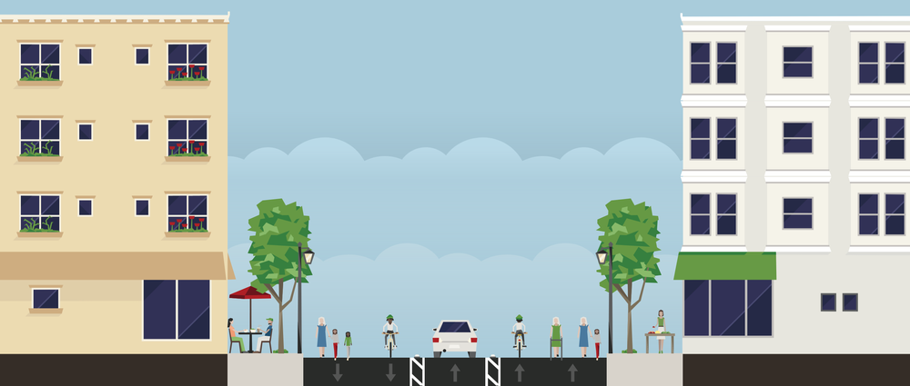
The final portion of this proposal will be the addition of more trees, the construction of flower beds, the use of string lighting, and other various beautification techniques. The overall goal of this is to further define Bryn Mawr Avenue as an enclosed public space, and to carefully delineate that it is for the use of pedestrians, businesses, and bikers, but only occasionally cars. These street interventions preserves Bryn Mawr as the central pedestrian street of Edgewater and develops the thoroughfare into a unique, and effective public space that will attract local residents and residents from all over the city. The final design of the street will look like the following diagram.
Figure 28: To-scale diagram of Bryn Mawr Avenue's street dimensions following interventions. Created using Streetmix.
With these improvements to Edgewater’s main boulevards, and with the addition of many new types of public space, the neighborhood will become a unique and important place that is not only a viable destination for residents of Chicago, but, even more importantly, a suitable place to live, work, and play. Residents will have easy access to important amenities just steps away from their residences making the neighborhood convenient and accessible. These improvements will solidify Edgewater as the amazing destination it used to be 100 years ago while still maintaining it as an area where people can go about their daily lives. This will make Edgewater one of the strongest neighborhoods in the entire city of Chicago.
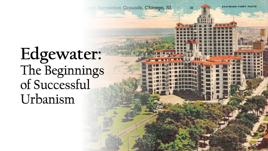
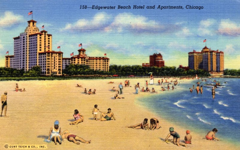
Edgewater Beach Hotel, 1941. Author unknown, Public domain, via Wikimedia Commons
Social Mix
General Neighborhood Statistics::
(With city-wide and regional data provided as reference)
Neighborhood Age Statistics::
Neighborhood Family Distribution::
Race distribution with Simpson Diversity Index::
Property value distribution with Simpson Diversity Index::
Housing type distribution with Simpson Diversity Index::
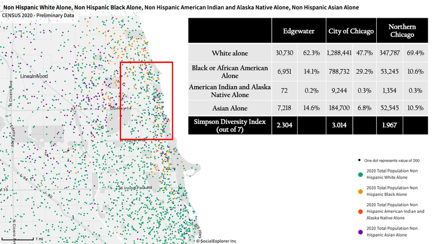
Upon first glance at Edgewater’s primary statistics, the neighborhood is clearly very dense, especially in comparison to Chicago and its subregion. It is over three times as dense as the City of Chicago, and about 1.5 times as dense as its fellow North Side neighborhoods. Being a neighborhood nearly eight miles from the downtown area of Chicago, this density is unexpected, yet this density seems to have interesting implications for the neighborhood’s diversity. First looking at the distribution of races around Edgewater, the neighborhood has a relatively wide array of racial representation, especially in comparison to other neighborhoods on the North Side of Chicago. The Simpson Diversity Index shows that the racial diversity in the neighborhood is 2.3 out of 7, which is a low score, but still around 0.4 higher than the surrounding neighborhoods. Looking closer into racial breakdowns, this is likely because of the Asian population, which accounts for 14% of Edgewater’s population, a percentage twice as high as Chicago as a whole. Edgewater is also 14% black, a percentage 4% greater than the North Side as a whole. Despite this, Edgewater still houses an overwhelming majority of white residents who make up around 62% of the neighborhood. Edgewater’s racial distribution is far from being perfectly diverse, however, it shows a level of diversity that other neighborhoods in the area were unable to foster. This is possibly due to the influx of minority residents during the housing shortage in the 1940s and 50s which attracted residents to the Edgewater neighborhood due to its availability of high-density housing. Along this line, the data above shows that Edgewater has an interesting distribution of housing types. It is far less diverse than Chicago and its region in this regard, scoring a 3.9 out of 7 on the Simpson Diversity Index while Chicago and the North Side scored 5.4 and 6.0, respectively. It seems this is primarily due to the large percentage of housing units that house 50 or more residents in Edgewater, a group that makes up 43% of Edgewater’s renter-occupied housing. In Chicago and on the North Side, this metric is a mere 19.1% and 25.4% respectively. The availability of high-density housing helps reconcile how Edgewater has achieved its high population density and attracted minority groups to the neighborhood in the mid-nineteenth century.
Another aspect of Edgewater’s demographic data which is interesting is the lack of diversity within the values of properties. After calculating the Simpson Diversity Index on the ranges of housing values in Edgewater, it was found that it has a relatively homogenous housing market, with an index of 4.062 on a neighborhood level as compared to an index of 4.982 on a regional level. This lack of diversity seems to primarily account for the large majority of properties within the price range of $150,000 to $299,999. Out of Edgewater’s owner-occupied housing, 41.8% of the properties are within these values, whereas on the North Side, only 27.3% of the owner-occupied housing falls within this range of values. On top of this, Edgewater has higher percentages of houses that fall in the ranges of prices below $150,000, whereas the region has a higher percentage of houses whose values are in ranges above $299,999. Edgewater lacks the wide variety of housing values that its region exhibits, yet its housing values tend to fall primarily in the lower-to-middle ranges.
When it comes to other demographic measures, such as family structure age distribution, Edgewater shows similar trends to its region, and Chicago as a whole. For example, the Simpson Diversity Index of the distribution of family structures in Edgewater and Chicago are 1.799 and 1.851 respectively on a scale of three. This level of diversity within family structures is actually quite impressive, given that the entire city of Chicago is a large area with many different groups of people and family structures, yet Edgewater is able to maintain similar levels of familial diversity on a much smaller scale. The same goes for the age distribution of Edgewater, as it has cultivated an age demographic very reminiscent of the overall composition of Chicago, with no clear majorities in its age groups, and a relatively even distribution of ages across the population. These demographic realities show that Edgewater has maintained a healthy diversity in family structure and age, two elements crucial to maintaining a prosperous community.
Note: demographic measures come from a 2020 ACS 5-year estimate survey accessed through Social Explorer.