Overview
Social Mix
Public Space
Amenities
Connections
Final Project
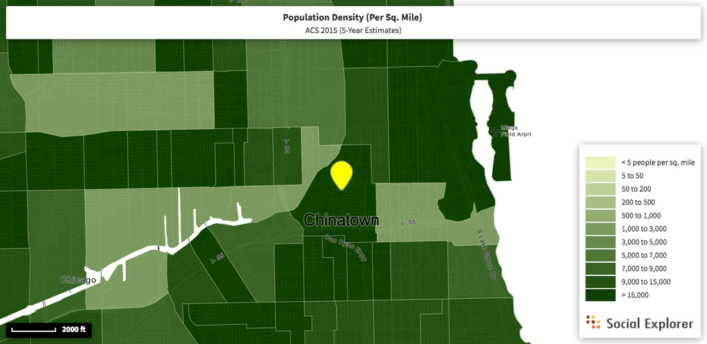
This map depicts population density by census tract. Most
neighborhoods do not align with their census tract. However, Census Tract 8411
aligns nearly perfectly with Christopher Devane’s delineation of Chinatown.
There are only slight differences is the northern and western boundaries. The
census tract has the northern boundary at W 18th Street and Devane has the
northern boundary at W 19th Street. This difference should not
affect the population count or population density because the blocks between W 18th
and 19th Street are mostly parking lots and nonresidential areas. The census tract has the western boundary just past Grove Street while Devane has
the western boundary one street farther east on S Tan Street. This difference
should also have little effect on the population count or density because Grove Street is not
residential.
Chinatown has a population of 7,673 people and a population density of 17,382.9 people per square mile, which makes it one of the more densely populated neighborhoods of the city. Chinatown is more densely populated than the Lower West side to the west (2,276.6 residents per square mile), the Near South Side, the South Loop to the northeast (about 14,000 residents per square mile), and Pilsen to the northwest (about 13,000 residents per square mile). Chinatown has a similar population density to Bridgeport to the south (about 15,000 residents per square mile).
Chinatown has a geographical area of approximately 294 acres
or .46 square miles using Census Tract 8411 delineations. This size is on the smaller
side for Chicago neighborhoods, but the area is densely packed with residents
due to the prevalence of apartment-style housing. Chinatown is a relatively residential area, but it maintains a strong commercial character as indicated by the bustling shops and restaurants all
along Wentworth Avenue and in Chinatown Square on the north side of the
neighborhood.
Chinatown has an impressive coherence, culture, and identity.
The neighborhood does an excellent job of balancing commercial tourism and densely packed residential areas. One might think that it would be difficult to
balance the constant presence of tourists and outsiders within a community. However,
the economy of Chinatown is largely dependent on this tourism and therefore the community must briefly integrate these visitors into their home.
The delineations of the neighborhood make use of natural fixtures, wide
streets, and transportation markings.
These strong delineations also contribute to the strong coherence of the neighborhood.
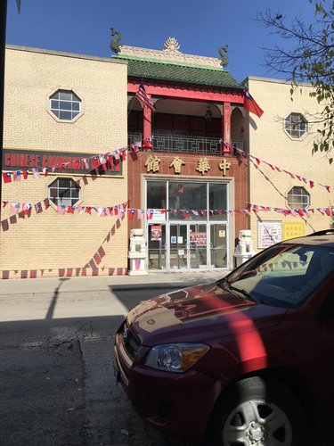
One aspect of Chinatown’s strong is its residential area. Pedestrians are present in all parts of the neighborhood. It is not uncommon to see elderly women walking up and down, quieter, residential streets of the neighborhood. Parents can be seen pushing strollers up and down walkways. A Chinese Community Center is present on 22nd Place, displaying Chinese and American Flags strung along the entrance. The building mixes Chinese and American architecture to create a warm, inviting ethnic character.
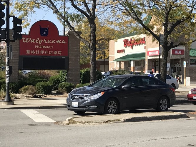
The coherence of the community is evident in the commercial section of the neighborhood. Every store sign is written in both Chinese and English, even the Walgreens. Aside from the Walgreens, Starbucks, and a handful of banks, each of the stores and restaurants in the community cater to the culture of their Chinese residents. On every commercial street, there is at least one Chinese medicine shop, Chinese bakery, Chinese restaurant, and small corner store stocked with Chinese brands. The architecture of nearly all commercial and retail buildings has a hint of Chinese style, whether it be a gargoyle, pagoda, or a fence on a porch.
These architectural accents and shop signs make the borders of Chinatown clear. Once one moves south of I-55, shops with signs in Chinese become sparse and then stop all together, giving way to other shops and restaurants. Each of the larger commercial areas, such as the entrance to Wentworth Ave, has a large gate reading “Welcome to Chinatown.” Likewise, the main public area, Chinatown Square, also has two gates on both the northern and southern entrances. The Northern border of W 18th or 19th Streets are appropriate because there is a border of large parking lots between Chinatown and the neighborhood to the North. The River is an excellent natural border to the West because there are few convenient places at which to cross it. The eastern border of Clark St is strong because that is the street that the ‘L’ Red Line runs along. The southern border is a bit trickier to define due to Chinatown’s growth and expansion in Bridgeport. The delineation is less clear, but it appears to be around W 26th St if one looks to shops and signs as indicators. The strength of coherence and clarity of delineation are evident to anyone who visits Chinatown.Layers:
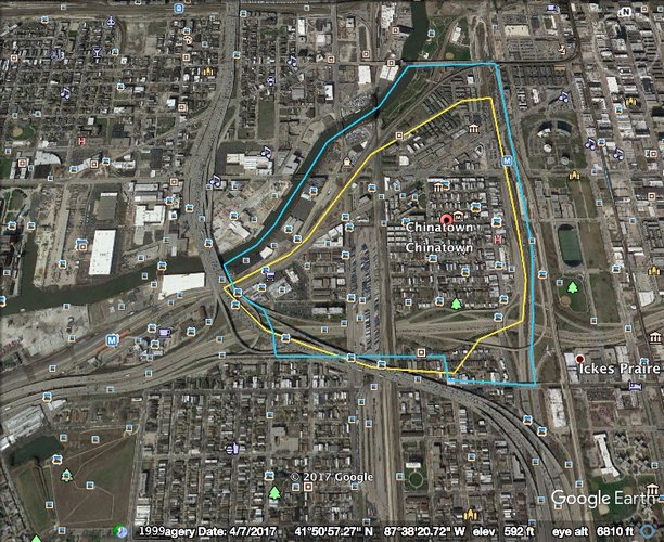
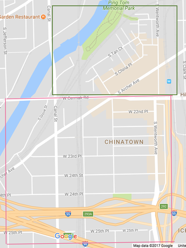
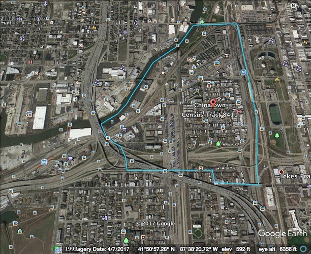
As previously stated, Chinatown is one of few Chicago neighborhoods that very nearly matches a census tract. Census Tract 8411 is represented by the blue outline and Christopher Devane's delineation of Chinatown is represented by the yellow outline. There are very few discrepancies between the two delineations. This similarity speaks to the clarity of Chinatown's borders.
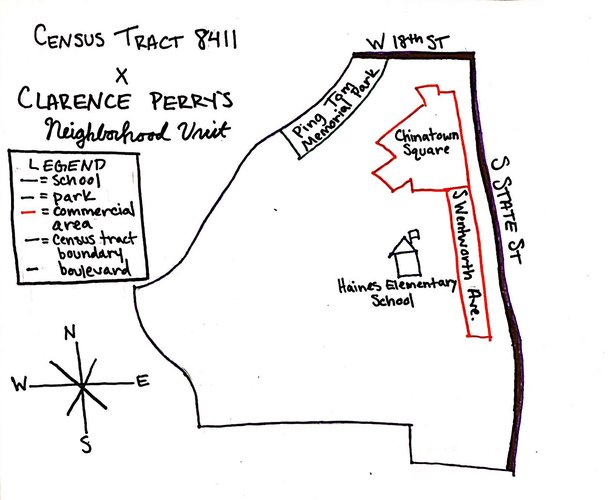
This map layers the delineation of Census Tract 8411 with aspects of Chinatown that align with Clarence Perry's theory of a Neighborhood Unit. The map depicts a central elementary school, significant park area, large boulevards along the border, and commercial space along the perimeter of the neighborhood.
Diagram:
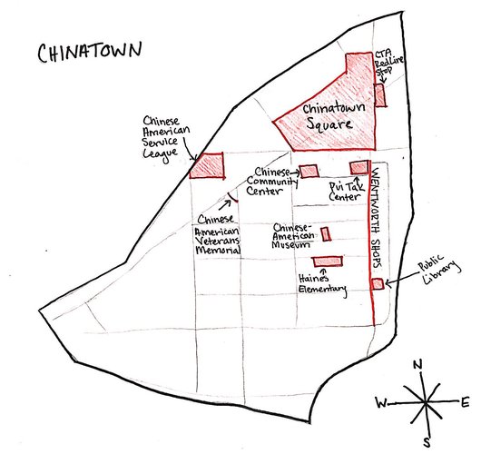
Chinatown was settled around Cermak and Wentworth in 1912. Prior to 1912, 25% of Chicago’s 600 Chinese residents lived between Van Buren and Harrison St in the Loop. However, a variety of circumstances including expensive rent, discrimination, overcrowding, and crime led these residents to migrate south to the Armour Square community area.[1]
The settlement of modern-day Chinatown was not spontaneous. The initial movement from the Loop to Armour Square was spurred by the On Leong Merchants Association, which commissioned the construction of a building along Cermak that could house 15 stores and 30 apartments meant for Chinese use.[2] The building was not constructed in strict Chinese architecture, but has hints of Chinese style. This movement was the seed from which all of Chinatown grew. The ethnic neighborhood of Chinatown expanded from this singular building. The residential areas of Chinatown spread southwest of Cermak and Wentworth and the commercial areas of the neighborhood continued growing along the streets of Cermak and Wentworth. In the late 1980s, businessmen further developed the area to the north of Cermak by erecting new housing options, particularly townhouses, and creating “Chinatown Square,” a public area and shopping mall/dining center just south of the new housing. The development of Chinatown can be organized into two time periods: its initial growth in the early twentieth century and its subsequent expansion to the north in the late twentieth century. There may be a third time period in the making as Chinatown is growing quickly and beginning to expand south into Bridgeport.
Accessibility to Chinatown has grown since 1969 when the Dan Ryan section of the L’s red line was opened. Although this train stop was not present when the neighborhood was first settled and therefore did not significantly influence its inception, this train stop has helped the tourism of the neighborhood flourish. People from all over the city have the ability to reach Chinatown via public transportation, boosting Chinatown’s economy, which is largely dependent on tourism.[3]
As noted in the “Layers” section, the layout of Chinatown very nearly matches Clarence Perry’s seminal model of The Neighborhood Unit. It is possible that the neighborhood developed in this way for a number of reasons. One of which is the presence of already-existing wide boulevards around the perimeter and the permanence of the Chicago River. Another reason is the settlement of commercial areas along the border of the neighborhood, which had been planned in the neighborhood's initial inception. The neighborhood of Chinatown is served by only one elementary school, which is logically placed in the center of the community in accordance with Clarence Perry’s Neighborhood Unit. These characteristics of Chinatown arose out of a delicate balance between urban planning and natural growth.
[1] Kiang, H. (1992). Chicago's Chinatown. Retrieved from http://www.encyclopedia.chicagohistory.org/pages/284.html
[2] Encyclopedia of Chicago. (2005). On Leong Merchants Association Building, 1928. Retrieved from http://www.encyclopedia.chicagohistory.org/pages/11597.html
[3] Chicago Transit Authority. (2017). Red Line (‘L’). Retrieved from http://www.transitchicago.com/redline/
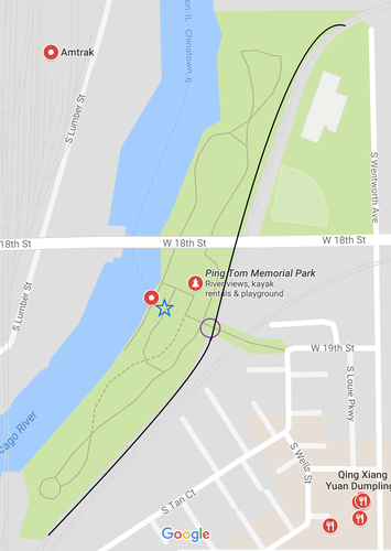
In Chinatown, there are an impressive number of public spaces open to its inhabitants, especially given the neighborhood's small geographic area of just .4 square miles. Some of these areas are well-utilized, while others are not. The sense of ownership of these areas can be determined by a number of factors including:
One public space that Chinatown has a definite sense of ownership over is Ping Tom Memorial Park, which is located in the northwest corner of the neighborhood. The park is well-kept. The grass is green and groomed. The paths are nicely paved, and the gardens are maintained. There is a constant presence of both locals and tourists in the park. It is clear that there is a cultural presence in the park, as indicated by the Chinese architecture of the buildings and park signage written in Chinese. The park has a beautiful pagoda (denoted by the blue star) in which to sit and engage in discourse, whether it be more intimate or within a large group. There is also an ample number of benches scattered throughout the park. Ping Tom Memorial Park is an excellent example of a well-utilized and a well-cared for public space.
The only drawback to this public space (unrelated to the sense of ownership) is the bordering train tracks (depicted as a solid black line), which block the entrance to the park (denoted by a purple circle). These tracks have the ability to trap park goers inside the park as a train passes.
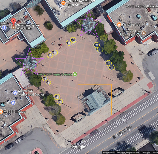
Chinatown Square Plaza is an example of a public space over which Chinatown has very little sense of ownership. The square is bordered by statues depicting the 12 Chinese Zodiac animals (denoted by yellow circles). However, many of these statues are missing plaques that are meant to be hanging below them, and the plaques that are present are riddled with typos. These statues indicate that the square is not very well-kept or cared for. However, the presence of these statues and the pagoda-like staircases (denoted by pink stars) are evidence of a cultural presence in the square. In addition to being uncared for, the square is usually devoid of people, which can be attributed to its lack of seating and area for private discourse. The area does have a center stage (denoted by an orange rectangle), which could lend itself nicely to larger community discourse, but it appears to be underutilized. Chinatown Square Plaza is an example of a public space that is not well utilized or cared for.
All images in this section were provided by Google Maps.
Chinatown is a small, dense, and close-knit community. The neighborhood’s amenities and businesses reflect these characteristics. Chinatown has a strong ethnic identity that is supported by a plethora of neighborhood-scale businesses. Nearly all of these businesses serve the unique demands of a Chinese population. In addition to these locally owned businesses, there are only a handful corporate enterprises. Most of these franchises are situated along the periphery of the neighborhood, which help to integrate the neighborhood with surrounding communities. These corporate enterprises generally serve needs unmet by the local businesses. This is evidence that local businesses and corporate franchises complement one another.
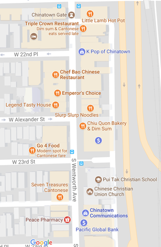
One of Chinatown's largest commercial areas is Chinatown Square. Of the many businesses located in Chinatown Square, none of them are large franchises. Many of these businesses serve local Chinese cuisine. Other establishments are also Chinese-oriented, such as Chinese-speaking electronic shops and tax services.
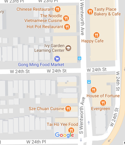
Another one of Chinatown's largest commercial centers runs all along Wentworth Ave. Like Chinatown Square, all of these businesses are small and locally owned. A number of these business are restaurants; however, there are also many corner grocery stores and a few banks.
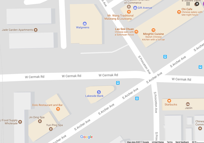
Aside from a handful larger banks including Citibank and Charter One, the only corporate franchises in Chinatown are a Walgreens on the northwest corner of Princeton and Cermak and a Starbucks on the southeast corner of Princeton and Cermak. These establishments are located on the western border of the neighborhood and serve needs that go unmet by the rest of the businesses in Chinatown. There exists no other store for western medicine besides Walgreens, and there is no other coffee shop besides Starbucks. As such, these establishments serve to support the neighborhood and its abundance of local businesses.
All images in this section were provided by Google Maps.
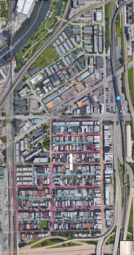
Chinatown features two different types of block structures: the elongated block and the irregular block. The older part of Chinatown (the southern part of the neighborhood) is characterized by elongated blocks (outlined in pink). The shorter sides of the blocks face Wentworth Ave (highlighted in yellow), the largest commercial street in the neighborhood, effectively creating more street corners and directing higher traffic thoroughfare in that direction. The longer sides of these blocks face the more rural, residential areas, allowing for a quieter living space with less traffic. The alleys that run through each of these blocks provide parking in places other than the street (highlighted in blue).
In addition to these elongated blocks, Chinatown also features a number of irregular blocks (outlined in green), particularly on the Northern and Western sides of the neighborhood. These irregular blocks are largely home to apartment complexes that have large lots either in front of them or behind them to provide parking. These irregular blocks vary in size and shape, disturbing the street grid of Chicago.
Like most of Chicago, the majority of Chinatown can be characterized by a Savannah Pattern network type (outlined in pink). The Savannah Pattern features a grid-like orientation of streets. This pattern offers good directional orientation and allows for easy access to alleys. Traffic is relatively evenly dispersed throughout the neighborhood, but the greatest amount of cars runs along Wentworth Avenue, Cermak Road, and Archer Avenue. The Savannah Pattern is an efficient network of streets within a neighborhood, but can be monotonous and does not accommodate environmental interruptions well, such as the Chicago River. The Chicago River interrupts the the grid system on the northern tip of Chinatown, necessitating the formation of irregular block types. Archer Avenue also interrupts the Savannah Pattern by running diagonally through the neighborhood. Although Archer Avenue does not fit with the Savannah Pattern, it is not detrimental to the neighborhood.
The northern tip of Chinatown can be best characterized as a Nantucket Pattern (outlined in green). The Nantucket pattern easily absorbs environmental interruptions such as the Chicago River. This pattern also limits monotony by offering more variation in block type and street size and shape. Although this variation may be interesting, it can sometimes become uncontrollable and hinder connectivity within the neighborhood.
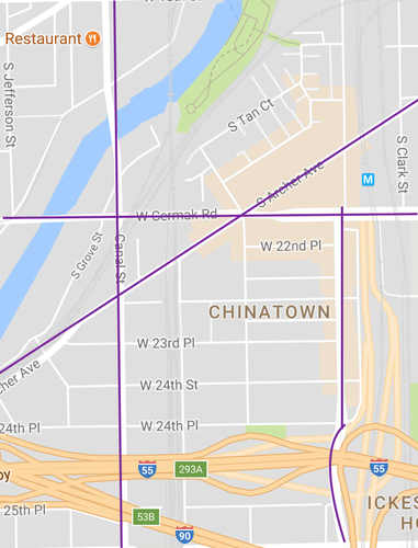
The thoroughfare of Chinatown is best characterized by a combination of streets (outlined in white) and boulevards (outlined in purple). Although many of the streets in Chinatown feature “Avenue” in their names, the majority of these thoroughfares are streets with a low car density and capacity. The remaining thoroughfares most closely resemble boulevards. These thoroughfares include Wentworth Avenue, Cermak Road, Archer Avenue, and Canal Street. They are designed for a high density of traffic at moderate speeds. These boulevards extend beyond the neighborhood of Chinatown and throughout most of the city of Chicago.
Overall, the general connectivity of the neighborhood of Chinatown is relatively strong. The walkways are always populated with residents of the area and there appears to be an air of cooperation among the residents.
The built environment in some ways enhances this connectivity and in other ways hinders it. In terms of block type, the prevalence of elongated blocks helps to keep the residential areas of the neighborhood insulated and intimate. The elongated blocks also direct pedestrians to the main commercial area of the neighborhood, Wentworth Ave. The irregular blocks hinder the connectivity of the neighborhood in that they stand apart from the majority of the residential blocks. They have a different, newer layout that is rather isolating. In terms of Network Type, the Savannah Pattern enhances the connectivity of the neighborhood and the Nantucket Pattern hinders it. The Savannah Pattern allows for easy maneuverability and directional orientation while the Nantucket Pattern is not as easily maneuverable or clearly oriented. The different networks of the northern tip and rest of Chinatown isolates the former from the latter. In terms of thoroughfare type, the combination of boulevards and streets overwhelming supports the connectivity of the neighborhood by bridging the busy, commercial areas of the neighborhood with the quieter, residential areas.
Chinatown is located just southwest of downtown Chicago. It has a population of 7,673 people and covers an area of 0.4 square miles. The population density of the neighborhood is 17,383 people per square mile, which is relatively dense compared to other Chicago neighborhoods. This density can be attributed to the prevalence of apartment-style housing in Chinatown. Chinatown is racially homogeneous, but diverse in terms of other factors, such as educational attainment. The neighborhood has a strong sense of identity fostered by the strong physical character of the area and the appropriate services provided to residents. In many senses, the neighborhood appears rather ideal. In fact, Chinatown's layout very nearly matches Clarence Perry’s model for the Neighborhood Unit.
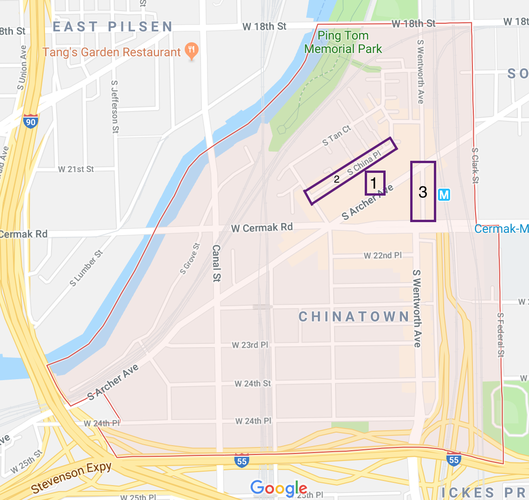
Despite this near perfection when compared to some models, Chinatown has room for improvement, particularly with respect to its public space. For its small size, Chinatown has an adequate amount of public space, but it is not utilized to its greatest potential. The two most prominent public spaces in Chinatown are Ping Tom Memorial Park located on the northwest border of the neighborhood and Chinatown Square located on the northern side of the neighborhood. Ping Tom Memorial Park is well-used and maintained. It accommodates the Chicago River and engages both residents of the neighborhood as well as visitors. On the other hand, Chinatown Square is underutilized. It is not well-used or maintained, and it creates a barrier between the newer, northern tip of Chinatown and the southern remainder of the neighborhood. In Chinatown, the underutilization of Chinatown Square has a detrimental effect on the neighborhood. To remediate this issue, I propose an intervention project called “The North-South Connection”. The purpose of this project is to increase the connection between the northern tip of Chinatown and rest of the neighborhood to the south by improving the public space that separates the two, Chinatown Square. This project contains three specific interventions.
The first invention is the widening of the northern gate of Chinatown Square with the purpose of increasing thoroughfare through the Chinatown Square Plaza. The widening of the gate would allow residents to flow freely from the southern part of the neighborhood into the north, as well as increased access to Ping Tom Memorial Park, which is located just northwest of Chinatown Square. This intervention was inspired the Charles Montgomery’s Happy City, which states, “Sometimes designers used gates and fences to achieve the desired antisocial effect (164).” In this case, the “antisocial” effect is the isolation of the northern tip of the neighborhood. However, I propose that this antisocial effect be removed by widening the northern entrance to Chinatown Plaza.
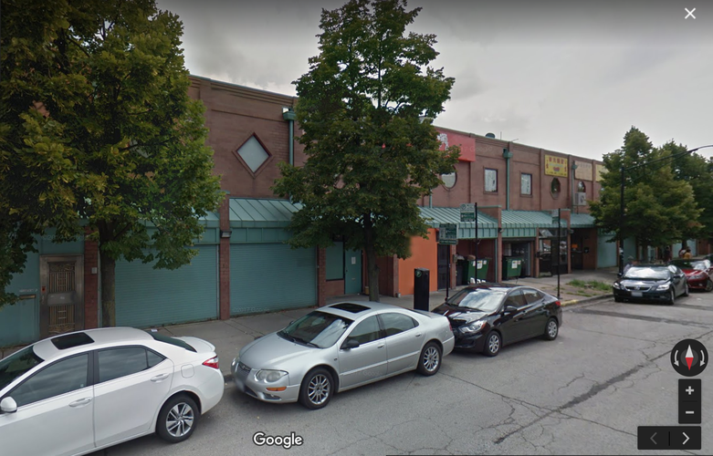
The second intervention I propose is the creation of storefronts and business entrances on the northern edge of Chinatown Square. Currently, the part of Chinatown Square that faces the northern tip of Chinatown looks like an alley. The strip of business is lined with dumpsters and green metal doors shut tightly, and it lacks store signage. Although the southern side of Chinatown Square does not contain the main commercial entrances to Chinatown Square, it does have clear signage for the business as well as many back entrances so that residents coming from the south can directly enter the businesses. I propose that the backs of the northern business are renovated to match those of the southern side, complete with clear signage and back entrances. As discussed in class, the residential blocks of the north terminate with their short sides facing the commercial street, S China Place, as they should. However, further commercial development through the implementation of business signs and back entrances could help to integrate the northern tip of Chinatown with the rest of the neighborhood.
The third and final intervention of this project is the beautification of Wentworth Ave between Archer Ave and Cermak Rd. As Daniel Baldwin Hess said in Pathways and Artifacts: Neighborhood Designs for Physical Activity, “The pathways offers ways to get from one meaningful place to another (64).” In this case, the meaningful places are the commercial drag of Wentworth Ave and Chinatown Square. I propose that this street be beautified to encourage thoroughfare between the northern and the southern regions of Chinatown. Currently, this stretch of Wentworth is desolate and grey, completely devoid of any character or neighborhood identity. This beautification could take a variety of forms. Trees could be planted along the western side of the street to match those on the eastern side. The gate around the parking lot on the eastern side could be replaced with the green metalwork characteristic of Chinatown to give the street a stronger architectural identity and continuity. Chinese flags are prevalent in Chinatown. Therefore, the erection of a Chinese flag to complement the American and Chicago flags at the corner of Wentworth Ave and Archer Ave would be reasonable. Beautification of this street will hopefully encourage greater pedestrian thoroughfare between the northern and southern region of the neighborhood.
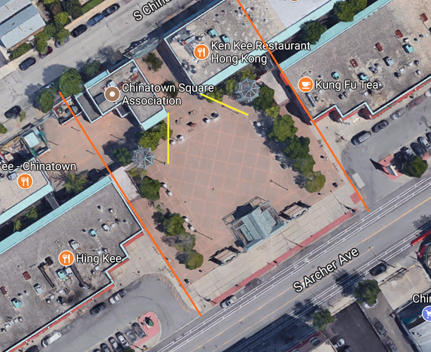
This aerial image shows the current constraint the small gate on the northern side of Chinatown Square causes to pedestrian traffic (shown in yellow). I propose widening the entrance to the size of the southern entrance (shown in orange) so that pedestrian can flow more freely between the north and south.
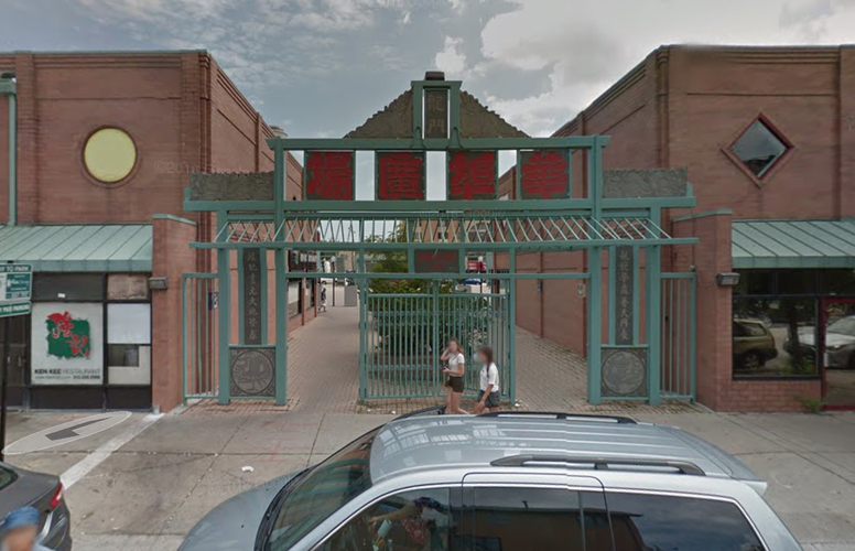
The northern entrance into Chinatown Square is very small. It constricts pedestrian flow into and out of Chinatown Square.
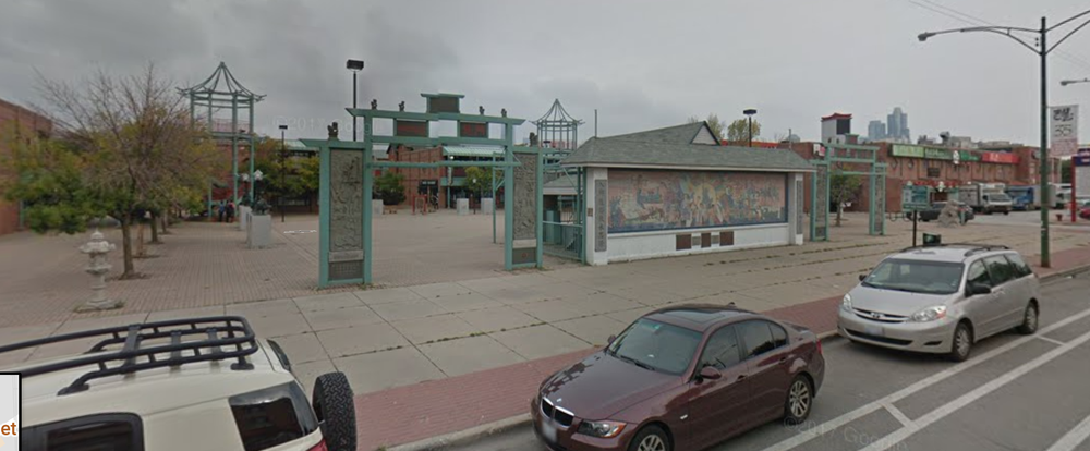
The southern entrance into Chinatown Square is much wider than the entrance on the northern side. This entrance allows for a free flow of pedestrians into Chinatown Square Plaza. I propose that the northern entrance be widened to the size of the southern entrance.
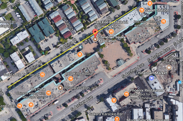
The yellow line indicates the area in which businesses should put up signs and create back entrances to increase the accessibility of their businesses to residents of the northern tip of Chinatown.
Currently, the portion of Chinatown Square facing the northern tip of Chinatown resembles an alley, complete with dumpsters and closed doors.
I propose that the northern edge of Chinatown Square be renovated to better resemble the southern edge, as pictured above. The southern edge of Chinatown appears to be more lively and accessible. It has ample store signage and back door entrances to businesses.
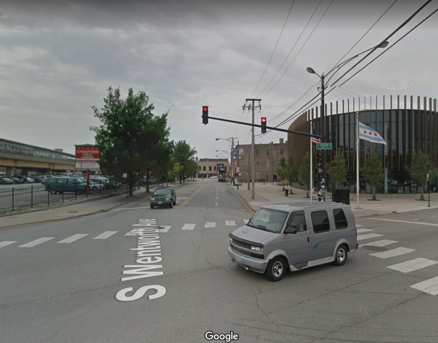
Currently, this stretch of Wentworth Ave is desolate, completely devoid of any character or identity. There is no indication that this street is part of Chinatown, and it is not an inviting place to walk.
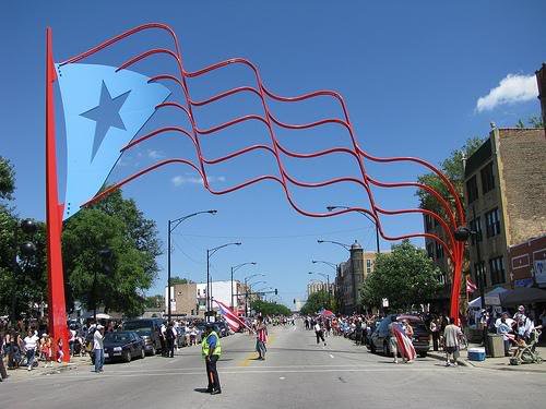
Although this is a dramatic example of a street with a strong neighborhood identity, the beautification intervention of Wentworth Ave could draw inspiration from places like Humbolt Park. The stretch of Wentworth Ave could incorporate the use of the Chinese flag as Humbolt Park has done with the Puerto Rican flag. A Chinese flag could be erected on the corner of Archer and Wentworth to complement the already-standing American and Chicago flags. Another method of beautification drawing inspiration from Humbolt Park could be the creation of murals painted along the sidewalk or sides of buildings. However, the erection of a Chinese flag, the replacement of the gates of the parking lot with the green metalwork characteristic of Chinatown, and the planting of trees and flowers on the western side of the street are the most viable methods of beautification for Wentworth Ave.
Bibliography for images:
Social Mix
The data above compares the diversity of Chinatown with respect to race, educational attainment, and housing value against Armour Square (Chinatown's community area as well as region), and the city of Chicago. The Simpson Diversity Index measures how even the demographic distribution of an area is across "n" numbers of categories. When reading and analyzing Simpson Diversity Index values, it is vital that one takes into consideration the number of categories the Index is measuring. For instance, in the table above, race was analyzed with respect to 5 different categories, so each of the indices should be read as value out of five. The higher the value is, the greater the diversity within the area. The data shows that Chinatown is not very racially diverse, as indicated by its Simpson Diversity Index of 1.41 out of 5. Armour Square is slightly more racially diverse with an Index value of 2.00. The city of Chicago is the most diverse of the areas considered with an Index value of 2.26. In terms of educational attainment, Chinatown is far more diverse compared to the other areas considered. Chinatown has a Simpson Diversity Index value of 4.03 out of 7 compared to Amour Square's value of 1.29 and Chicago's value of 0.83. In terms of housing value, Chinatown is not very diverse according to the Simpson Diversity Index. Chinatown has a value of 2.89 out of 9 while Armour Square has an Index value of 3.11 and the city of Chicago has an Index value of 4.19. The Simpson Diversity Index shows that Chinatown is diverse in some aspects, such as educational attainment, but not as diverse in others, such as race and housing value.
All data for this section was provided by Social Explorer and the 2010 Census.