Overview
Social Mix
Public Space
Amenities
Connections
Final Project
Size
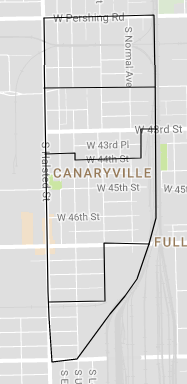
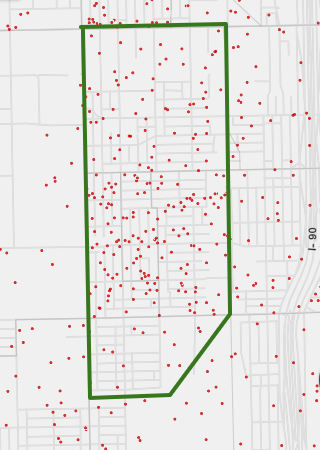
Canaryville has a population of about 6,480 people, according to Social Explorer (the green outline on the map above encloses Canaryville, and each red dot represents 25 people). The neighborhood covers 0.6 square miles, so it is easy to travel. The north end and the south end are 1.3 miles apart, and the east and west boundaries are separated by half of a mile; perhaps more pertinently, the neighborhood is thirteen blocks long and four blocks wide. The narrow nature of Canaryville fits it pretty nicely into Clarence Perry's ideal quarter-mile radius to a neighborhood, and well within Jane Jacobs' population target.
Identity
My walk around Canaryville gave me a strong sense that the neighborhood is a cohesive unit. It is delineated on two sides by wide through streets (South Halsted Street and West Pershing Road), while none of the internal streets running north-south are through streets: in fact, most of the internal streets are only a block long, leading to very light traffic within Canaryville itself and lending the space to a bustling scene of children playing and families walking to church on a bright Sunday morning.
People were out using the public space, although there is not very much of it in Canaryville. Canaryville has only two small parks that I saw, and one is adjoined to the public elementary school. I noticed people caring for and about the public space, which says to me that they are invested in the neighborhood community and interact with their neighbors. Many of the houses I passed were decorated for Halloween in some way, although the holiday is still two weeks off; I imagine that these homes are expecting trick-or-treating neighbors, and decorating so far in advance to add fun and festive spirit to the streetscape shows care for neighbors. There was almost no litter on the sidewalks and streets, despite a total lack of garbage cans provided by the city. To counter this lack of garbage depositories, several houses I walked past had placed plastic bags over the fences surrounding their front yards for neighbors and passerby to put litter into. This extra level of care for the way the streets look indicated to me that people who live in Canaryville care about their community.
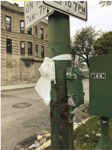
I saw other markers of community in the neighborhood. There were white plastic bows tied around fences and lampposts (both public and private property), which I believe to be vestiges of a recent festival for a Catholic saint. Irish Catholicism as an identity runs high in Canaryville, with many homes displaying a sign for a Catholic high school or a shamrock in their yard decor. Canaryville’s strong history as a home to public employees, specifically veterans, cops, and firefighters was made clear by several flags and signs honoring these groups, especially signs proclaiming that “Blue Lives Matter.”
The name “Canaryville” is also central to this small space, often lumped in with Back of the Yards and other white ethnic neighborhoods on the southwest side of Chicago. Most notably, many homes sported a super creepy sign in the window proclaiming “Canaryville Watch Group: We Call the Police!” I was honestly concerned that being a stranger wandering around taking photographs of people’s homes would earn me a conversation with a cop, but I imagine that the time of day combined with my race saved me from the Canaryville Watch Group’s ire. I was also worried about drawing glares as an outsider, but I experienced the opposite: people called out to greet me from their porches, wished me a nice day, and offered to hold the bus I was rushing towards as I left the neighborhood. While the watch group’s signage was the most prominent proclaimer of the name Canaryville, the Chicago Public Library’s Canaryville branch and the Canaryville Veterans’ Association also made the neighborhood’s name known. Unlike Bridgeport and the Yards, which have mixes of Polish, Chinese, Mexican, and other ethnic residents and have restaurants, shops, and houses of worship dedicated to these cultural groups, Ireland was the only motherland I saw claimed in Canaryville, and I saw it held with pride many times over. From what I saw on my brief stroll, this small neighborhood has clearly defined boundaries and a clear sense of its own history and culture.
Layers
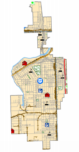
Because Canaryville is so small, both in terms of acreage and population, it is often part of a larger chunk of the southwest side when Chicago is split up into parts (as in Community Areas and aldermanic wards). Above is one instance in which Canaryville is split up rather than being entirely included in one part of the city: four different elementary school districts encompass different parts of Canaryville. Each of these four elementary schools also draws students from other surrounding neighborhoods, and only one of the schools (Graham School) is actually located in Canaryville itself. A single public high school, Tisdale High School, serves all of Canaryville, although it is popular in the neighborhood to school children in Catholic parochial schools. Only one parish, St. Gabriel's, is located within the boundaries of Canaryville, but many other Catholic churches are within close range. Canaryville is encompassed entirely within the eleventh aldermanic ward, along with good-sized parts of Bridgeport and Back of the Yards.
A Brief History of Canaryville
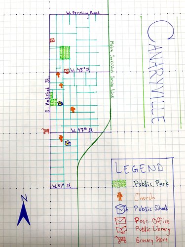
Although culturally distinct from other neighborhoods in the New City community area of Chicago, Canaryville shares history with Back of the Yards in that it was originally populated by Union Stockyards workers from the 1860’s until the decline of the meatpacking industry in Chicago sparked by wartime stress on factories and increased pressure on the industry to treat its workers better and improve its sanitation standards. After the jobs in meatpacking plants began to disappear, the leading employers of young Canaryville men were the United States Armed Forces and the city of Chicago, which employed Canaryville residents mainly as first responders like police officers, firefighters and EMTs.
Because of the high proportion of Canaryville breadwinners who were employed by the city, it was one of the South Side neighborhoods that did not experience White Flight in the years after the Supreme Court’s decision to deem racial restrictive covenants unconstitutional in 1948. Because the residents of Canaryville made modest incomes, and because many were required to reside within the limits of the city of Chicago in order to maintain their jobs with the police or fire departments, Canaryville remained almost entirely white throughout the twentieth century and is still strongly Irish Catholic today. Since people selling their Canaryville homes were legally disallowed from restricting the buyers to white people, but the residents were racist and did not want Black neighbors, teenagers and gangs in Canaryville resorted to racial violence in order to scare Black people away from their neighborhood, which is just west of the CTA Green Line from Black neighborhoods like Bronzeville and Washington Park. As recently as 1989, a group of white teenagers attacked a Black teen who was passing through Canaryville, and on my reconnaissance over the weekend I noticed a faded confederate flag.
I have heard three tales of how Canaryville got its colorful name. The first is that canaries lived in this part of Chicago before it was densely populated, picking over scraps from the Union Stockyards and the train cars passing on what are now the tracks for Metra’s SouthWest Service line. Another origin story derives from “canary” as a nineteenth century slang word for a tough teen, the kind who lived in this part of Chicago and joined one of the gangs that roamed the Southwest side. My favorite is the story that claims that when Appalachian coal miners moved from West Virginia to Chicago to work in the stockyards, others nicknamed their home after the canaries that would be the first voyagers into a coal mine to check for deadly gasses. The fact that the origin of Canaryville’s name is no longer known is a testament to the long history of this neighborhood and how it has endured as a distinct cultural community despite its size.
Works Cited
Archdiocese of Chicago. "Parish Finder." Accessed October 16, 2017. archchicago.org/parish-map.
Barrett, James R. "Canaryville." The Encyclopedia of Chicago. Accessed October 12, 2017. encyclopedia.chicagohistory.org/pages/2476.html.
Barrett, James R., and David R. Roediger. "The Irish and the" Americanization" of the" New Immigrants" in the Streets and in the Churches of the Urban United States, 1900-1930." Journal of American Ethnic History 24, no. 4 (2005): 3-33.
Chicago Public Schools. "CPS School Locator." Accessed October 15, 2017. cps.edu/map.
City of Chicago Office of the Mayor. "Wards Overview Map." Accessed October 15, 2017. cityofchicago.org/content/dam/city/about/banners/WardsOverviewMap.pdf.
Davis, Myron. “Canaryville.” University of Chicago Research Paper, doc. 1a, in “Documents: History of Bridgeport.” 1927. Chicago Historical Society.
Papajohn, George. "Racial Tension Fact of Canaryville Life." Chicago Tribune, August 18, 1991. articles.chicagotribune.com/1991-08-18/news/9103010300_1_black-em-flats.
Shanabruch, Steve. "Canaryville." Accessed October 11, 2017. thechicagoneighborhoods.com/Canaryville.
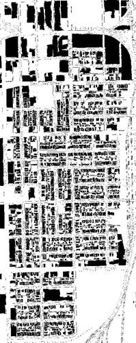
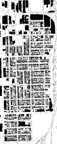
This figure ground map shows built space in black and unbuilt space in white. The effect of the train tracks that create the eastern and northern boundaries of Canaryville is clear in this map: the huge swath of unbuilt space creates a clear edge to the neighborhood and gives it internal community, since it is unpleasant to walk over the train tracks, and they require a lot of empty surrounding land for safety that cannot be otherwise used. The other large white spaces are parks and schoolyards. The big chunks of black area are a parking lots and two large areas in the northeast of the map that used to be part of the Union Stockyards and have never been repurposed. While I saw families using the parks on the weekend, the old Stockyards land is empty and would not be a pleasant place to spend time. The street is vibrant in Canaryville, filled with kids riding bikes, Halloween and saints' days decorations on fences and lampposts, and old people reading newspapers on their front porches. This diagram demonstrates well how the houses in Canaryville are almost all set back from the sidewalk by a front lawn, making the streets less claustrophobic and thus more inviting, even if it would be rude to play in a stranger's yard. I think it captures built and open space really nicely, while missing the nuances of how these spaces are public and private: another vibrant public space is the Canaryville Branch of the Chicago Public Library.
Note: I created this figure ground diagram in GIMP, a free and open-source image manipulation software (www.gimp.org). I made it using information provided by Google Maps (maps.google.com) and OpenStreetMap (www.openstreetmap.org). My personal visits to Canaryville as well as sources cited in the Overview section inform my writing. If you would like to see the diagram in greater detail, you can download a vectorized version below.
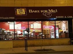
Top: the storefront of Bake for Me!, a popular Canaryville bakery.
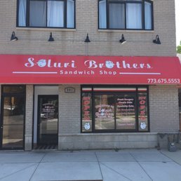
Bottom: Soluri Brothers Sandwich Shop opened in 2017 and has become a local favorite.
Unusually in today's monopoly-driven market, Canaryville is a bastion of local businesses without a corporate chain on the block. Along the main commercial drag of Canaryville, 43rd Street, there are several local businesses including neighborhood favorites like Bake For Me! Bakery and Soluri Brothers' Sandwich Shop. I only saw one chain on this street: a State Farm insurance office. While we might say that it is best not to have any national corporate presence in a neighborhood, a relatively poor neighborhood like Canaryville certainly would not be able to support an insurance set-up, because insurance companies need a wide pool of clients to ensure their bottom line and reduce risk. In fact, because Canaryville is so small, there are some services that it just doesn't have at all, and a chain would be better than the current complete lack. Canaryville does not have its own grocery store, for example; residents must shop at a store in nearby Back-of-the-Yards. A Jewel Osco might not be preferable over a local corner grocer, but right now no grocery at all exists within a ten-minute pedestrian shed of most of the neighborhood's population. Similarly, while local banks have more moral character than corporate Wall Street banks, Canaryville residents need some bank on the block for everyday deposits and withdrawals. This neighborhood has been passed over by corporate chain interests, which has resulted in fewer amenities for its residents.
Note: this section is informed by Google Maps and my personal visits to Canaryville. The images used are sourced from Zagat and Yelp respectively.
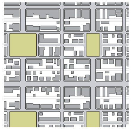
The block types in Canaryville, shown in the figure ground diagram (top), are elongated blocks arranged in the Savannah style (bottom).
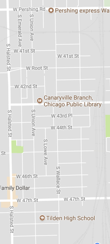
As seen in this image from Google maps, the street network in Canaryville has a dense array of connections. Blocks are tiny and the streets intersect about every two hundred feet.
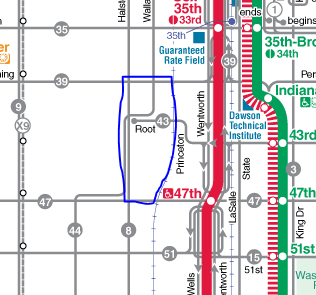
An excerpt of Chicago's transit map. The approximate area of Canaryville is outlines in blue.
Chicago's Canaryville neighborhood is very well connected in terms of block and network type. The small blocks create tons of intersections, meaning that neighbors are encouraged by the infrastructure to interact and there is little traffic through the neighborhood. Small blocks also encourage small-scale development, giving Canaryville a homey feel. The block type creates the dense network; small blocks mean that a neighbor six blocks away is a very brief walk, whereas the same number of blocks might be a mile's trek in a different neighborhood.
Canaryville's great system of blocks and street networks makes it feel like a home; the area is pretty homogeneous, as well, giving its residents a sense of belonging. Canaryville also has a reputation for being insular and even hostile towards outsiders, a problem that may be exacerbated by the few connections to other parts of the city. There are few street thoroughfares in Canaryville, creating the low-traffic conditions that encourage people to spend time on the streets, altogether good for neighborhood community. However, the lack of through streets also mean that the neighborhood has little access to transportation infrastructure like buses, trains, bike lanes, and even easy drives in the car. These three elements of planning combine to create a fenced-off, tight-knit community.
Canaryville has struggled with social isolation throughout its history on Chicago's Southwest side: what little reputation it has city-wide is of hostility towards outsiders, especially those who fall outside its Irish Catholic populace. While no social ill, especially racism, can be attributed solely to structure rather than to the choices of the individuals who perpetrate it, more social connection with people from around Chicago, the Great Lakes region, and the country at large can be hugely beneficial in assuaging fear, hatred, and the perceived need for an in-group mentality in the face of marginalization. Canaryville is small, but by no means does that relegate it to a destiny as a poor residential area adjacent to the amenities that make Chicago a world-class city. On the contrary, Canaryville could be part of what makes Chicago great rather than what make it daily headline fodder if it were more connected to the rest of the city both physically and socially. More connection would be a boon for the small businesses already making their home in Canaryville and provide residents with access to some of the best things about their city.
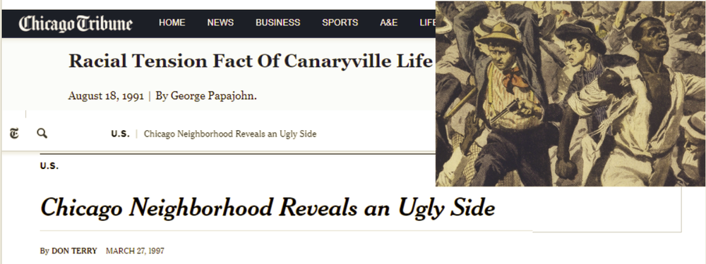
Canaryville struggles to connect with the rest of Chicago: its limited reputation is of hostility towards outsiders. Images (clockwise from top left) are from The Chicago Tribune, The History Channel, and The New York Times.
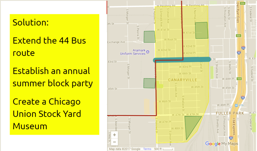
I have designed three interventions with the goal of weaving Canaryville into the social fabric of Greater Chicago: an extension of the bus route marked in red, a block party along West 43rd Street marked in blue, and a new museum dedicated to the history of the Union Stock Yard, for potential sites for which are marked in green. Image is my own illustration overlaid on an excerpt of Google Maps.
First up in the process of connecting Canaryville to the rest of Chicago and vice versa is improving public transit access to the neighborhood. As of now, Canaryville is served most directly by the 8 bus, which runs north and south on Halsted Street, the 43 bus, which runs east and west on 43rd Street, and the 44 bus, which runs north to the Orange Line stop at Archer Avenue and Halsted Street, where it stops.
Canaryville is serviced by three main buses, the 43, 44, and 8, none of which go to the transit hub of Chicago. Image from the Chicago Transit Authority with the approximate boundaries of Canaryville outlined in purple.
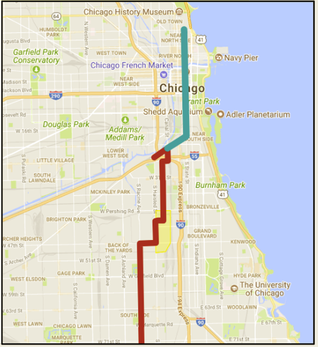
For better or for worse, all train lines in the Chicago Transit Authority system convene in the Loop, making it Chicago's transit hub. Because Canaryville has no direct access to the Loop, riders must transfer two or three times to reach their destination. This makes venturing into or out of Canaryville on transit more expensive, more confusing, and more time-consuming. If the 44 bus ran directly through the Loop rather than stopping at Archer Avenue, it would cut one transfer off of most travel to and from Canaryville. I propose extending the 44 bus route through the loop, across the Chicago River, and all the way to the intersection of State Street and Division Avenue in River North. This change would give Canaryville residents access to downtown jobs, many of Chicago's museums and cultural centers, and the shores of Lake Michigan. Just as crucially, it would make it easier for other Chicagoans and visitors to come visit what Canaryville has to offer.
Canaryville and surrounding communities would benefit from the current 44 bus route, drawn here in red, were extended through the Loop (my proposed extension is drawn in blue). Image from Google Maps with added drawing by me.
One of Canaryville's most distinctive features is its strong Irish Catholic heritage, exemplified in Saint Day celebrations that include fairs and parades.
An outdoor decoration left over from a recent Saint Day celebration. Photograph is my own.
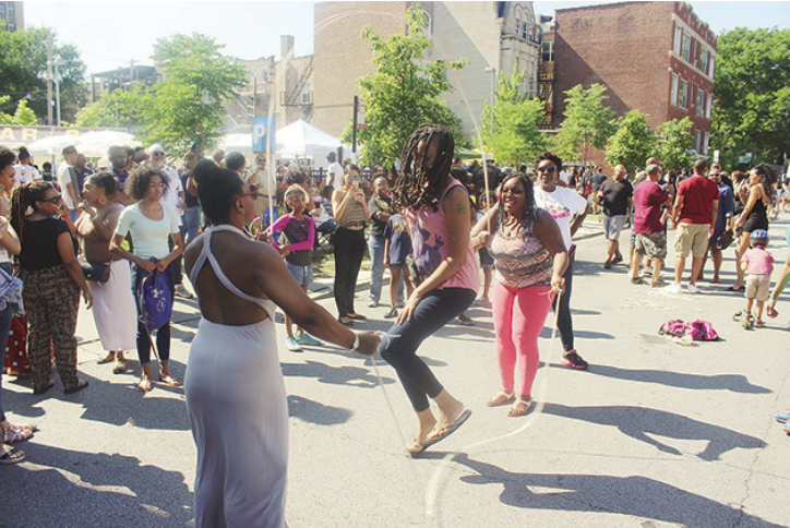
Catholicism has the power to be a unifying force in Chicago, playing a prevalent role in ethnic communities as disparate as Filipino, Puerto Rican, Polish, Mexican, and Irish. My second recommendation for connecting Canaryville to the rest of the city is to invite neighbors from across Chicagoland to these celebrations. Chicago's summer block parties are a highlight of the year, and they bring people together for food, laughter, and community bonding. A main stage could showcase Canaryville musicians while local artisans sell wares from covered booths along with local businesses and food vendors. Canaryville's public space along the main commercial drag would be activated by a community event that closes traffic and focuses on connecting with others.
This picture shows a sweet day to be had by all at this block party held by The Silver Room in Hyde Park in Summer of 2016. Image from the Hyde Park Herald.
The final part of my three-pronged approach to bringing Canaryville closer to the center of Chicago's public life is to establish a tribute to the neighborhood's history that draws people from all over to learn about its interesting past and experience its present charm.
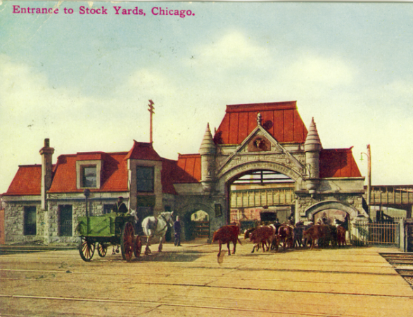
The Union Stock Yard Gate, located at the western edge of Canaryville, is a National Historic Landmark and the only formal commemoration of the Union Stock Yard in the place where it existed. Image from the Chicago Postcard Museum.
Canaryville's history started in tandem with the history of the Union Stock Yard, the giant meatpacking company that was the cornerstone of Chicago's infamous meatpacking industry. This industry, popularized in Upton Sinclair's novel The Jungle, has remained central to Chicago's historical imagination. It is one of the parts of Chicago's history that tourists are most interested in learning, and thus far there has been no institution dedicated to the study of this history in the place where it transpired. To address this need, I would like to establish a museum in or adjacent to Canaryville that contains artifacts and resources to teach visitors about how meat was processed, the lives led by stockyard workers, and the lasting effect Chicago's meatpacking industry had on the city and the country at large. I have outlined four potential sites for a museum focused on the Union Stock Yards: two that are abandoned meatpacking plants in which animals were processed, and two rail yards in which the meat was shipped across the country. This small museum would create jobs for Canaryville's people, and bring geographically diverse connections right to their home neighborhood.
With these three projects, I hope to raise awareness within and outside of Canaryville that this small neighborhood is part of what makes Chicago great, rather than just a residential neighborhood adjacent to the cosmopolitan areas of a world-class city. The first step towards that goal is physical, emotional, and social connection with other neighborhoods and diverse people and parts of the city.
Social Mix
Simpson Diversity Index Table
Canaryville New City community area Southwest Side of Chicago Chicago as a whole
Income (out of 4) 3.814886 1.071513 3.411312 3.950868
Age (out of 4) 3.173016 3.405319 3.46969 3.453295
Race (out of 5) 1.626438 2.720484 3.164233 2.852888
Diversity Analysis
When I completed my initial reconnaissance of Canaryville last week, I came to the conclusion that Canaryville is not diverse: it has a strong ethnic identity as Irish, a strong racial identity as white, and a strong religious connection to Catholicism. After class discussion and after crunching the numbers, I can see the ways in which Canaryville is diverse after all. First of all, while it is firmly middle/working class in its identity, Canaryville has families with a range of incomes. This is represented in the high Simpson Diversity Index score the neighborhood receives for income level, and is underlined by the mix of single- and multiple-family homes and by the near-even split between renters and owners residing in the community’s houses. While I did not create a table that included Hispanic and Latino heritage, I believe that many people in the “Other” and “White categories in the race table identify such, and this makes Canaryville a bit more diverse ethnically than is represented in the table. I chose not to include Latino ethnicity because, being a white Latina myself, I believe that the structural discrimination against Latino communities stems more from many being racially Mestizo rather than from ethnicity, and I believe this is captured in the race category. Canaryville also has a fairly even distribution of age groups, although it skews young; perhaps there are not health or social resources nearby for seniors, making it difficult to “age in place.” While Canaryville has these elements of diversity, its identity as a white Irish Catholic neighborhood makes it hostile for people who do not fit into this category, from what I have read. I would say that Canaryville has the kind of diversity needed for a functional neighborhood, but not the kind of diversity we strive for as planners and as citizens of Chicago.
Note: all statistics and demographic measures come from a 2015 ACS 5-year estimate survey. I accessed them through Social Explorer. The works cited in the Overview section also informed my findings in this section.