Overview
Social Mix
Public Space
Amenities
Connections
Final Project
Size
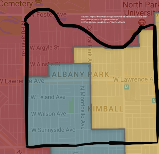
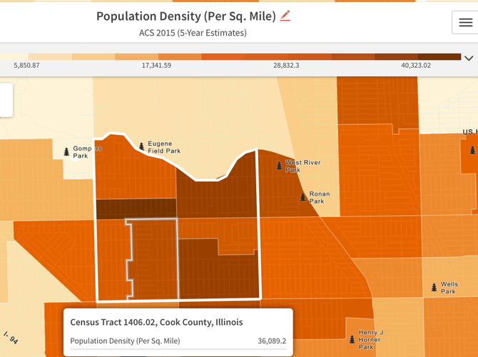
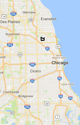
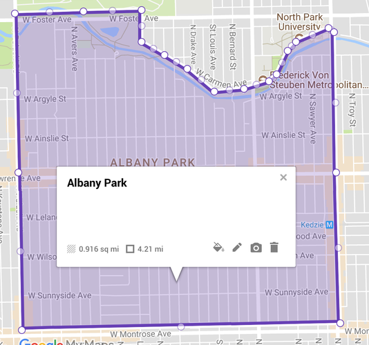
Albany Park is approximately 0.93 miles square, or 595 acres (1), with a population of around 30,109 residents (2). The neighborhood contains multiple elementary schools, indicating it is larger than Perry's ideal neighborhood size of one elementary school. It contains about 2/3 the area and only 1/3 the population of Jacobs' districts.
Layers
Identity
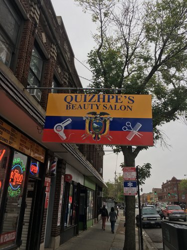
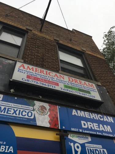
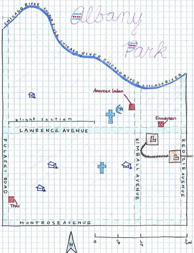
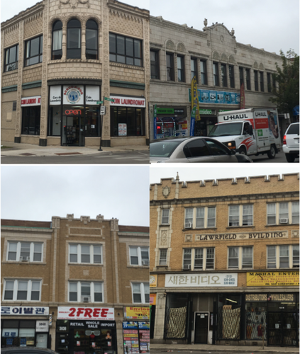
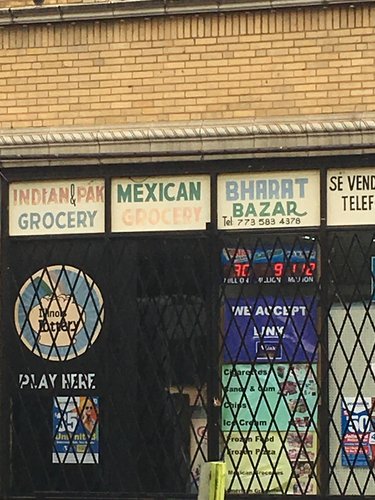
Albany Park’s main commercial thoroughfares give off a strong sense of definition. Lawrence Avenue, the main commercial drag (between Pulaski Drive and Kedzie Avenue), contains a profusion of small businesses packed tightly together. They do not give off the impression of belonging to a particular ethnic neighborhood, but they indicate the importance of ethnic heritage to Albany Park’s residents: Korean, Mexican, Ecuadorian, Yemeni, Chinese, Indian, Pakistani, Thai, and Serbian Americans are represented in the businesses and institutions of the neighborhood, among others. The common feature nearly all the shops share with each other is that the owner’s national origin features prominently in the store’s name, décor, or offerings. This trend extends beyond businesses that normally cater to specific ethnicities, like grocery stores or pharmacies: even hair salons and electronics stores have foreign flags out front. Notably, Lawrence Avenue also contains several businesses and centers providing immigration services. The character of Albany Park’s business community reveals perhaps the two most essential defining characteristics of the neighborhood: its multi-ethnic population and its role as a haven for immigrants.
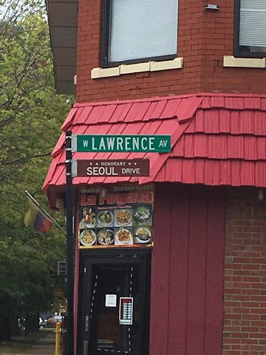
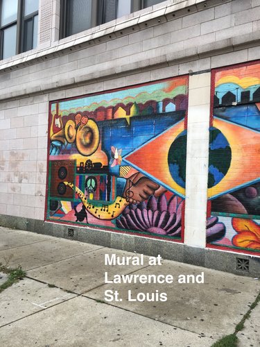
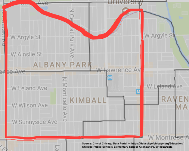
Local business names and public facilities provide a good idea of the neighborhood’s boundaries as well. From The Albany Park Bank & Trust (“Albank”) to the Albany Park Fresh Market to the Albany Square Outlet Mall, Lawrence Avenue abounds with businesses named for the neighborhood. A mural depicting some of the transit that runs through the neighborhood as well as a variety of musical traditions can be found on Lawrence and Saint Louis. The Albany Park Community Center is only a block north on Ainslie Street. West of Pulaski Avenue, however, most businesses bear the name “Mayfair” rather than Albany Park, indicating a sharp boundary. This divide also appears in the nature of the businesses themselves; while the businesses east of Pulaski are almost exclusively local, big-box stores populate most of the business space west of Pulaski. Street names also provide a clue: Lawrence Avenue is officially nicknamed “Seoul Drive” from Pulaski to Kedzie, and several streets within the neighborhood have been named after locally important people.
Diagram
History
Albany Park’s raison d’être has always been its transportation connections. Its first settlers were farmers, mainly of German and Swedish descent; as Chicago’s population boomed in the later decades of the 19th century, it gained popularity as a suburban community. The area was absorbed into the City of Chicago with the 1889 annexation of Jefferson Township, of which is was a part. What really set off the neighborhood’s development, however, was a large land purchase by a group of investors in 1893. These investors, who gave the neighborhood the name Albany Park after the city of Albany, New York, brought streetcar lines to the area. Fourteen years later, the Ravenswood Elevated Line (now the Brown Line) was extended to Kimball, and the retail corridor along Lawrence Avenue exploded due to the increased traffic. The easy transit connection to downtown that the El provided also spurred residential development. The Brown Line still serves as a major lifeline to the neighborhood, and Lawrence Avenue remains Albany Park’s economic and social heart.
The development of the Albany Park neighborhood that followed the advent of the El appears to be the dominant push in shaping the local built environment. The residential areas contain the bungalows and red- and yellow-brick three-flat apartments common to this period of development in Chicago; some homes also show the influence of the Prairie Style. Many commercial buildings, particularly along Lawrence, feature Art Deco-style embellishments, and the buildings whose dates of construction are carved into the stone were mainly built in the 1910s and 1920s. While the primary residents of Albany Park in its early decades were Northern European immigrants, its population in the post-El years through the Second World War were mainly Russian and Eastern European Jews expanding from the slums of the Near West Side. The Jewish residents of this second chapter in Albany Park’s history built up the neighborhood densely, and their exodus to the suburbs in the late 1950s along with much of Chicago’s Jewish population seriously hurt the area.
The neighborhood reached its nadir in the late 1970s both in terms of economy and population. The most jarring sign of its decline was the increase in storefront vacancies along Lawrence Avenue, the street that best serves as a bellwether for the neighborhood’s health. Redevelopment efforts sponsored by the city came in 1978, and through the 1980s and 1990s Albany Park experienced a renaissance. In this third chapter Albany Park welcomed immigrants from East and Southeast Asia, the Middle East, South Asia, and all over Latin America. Most influential were the Korean immigrants, who spurred much of the economic redevelopment. Though some of the Korean population has since moved to the suburbs, the neighborhood has a strong Korean presence, and their role in reviving Albany Park is reflected in an officially designated nickname for the stretch of Lawrence between Kedzie and Pulaski: “Seoul Drive”. Traces of the neighborhood’s old inhabitants remain, however, in the buildings and place names. A Pentecostal church on Ainslie and Bernard, for example, occupies a building that was clearly once a synagogue called Beth Israel. Albany Park’s proximity to transportation and large variety of housing options have made it an attractive choice for new immigrants from various corners of the world throughout its history.
Sources:
· Encyclopedia of Chicago, “Albany Park.” http://www.encyclopedia.chicagohistory.org/pages/36.html
· WBEZ, “Albany Park, Past and Present.” https://www.wbez.org/shows/wbez-blogs/albany-park-past-and-present/da30b2d1-6cc2-4a46-8b40-d42d82b8797f
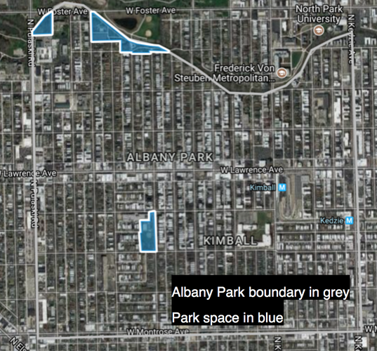
The most remarkable observation about Albany Park’s civic spaces is this: there essentially are none. Besides parks, there are no major government centers, open plazas, or other places for pedestrians to congregate: the res economica has swallowed up the res publica. Public buildings like schools and gathering places like churches abound, but these are not civic centers in the sense that they provide a space for casual socialization. None of them provide opportunities for formation of the “weak ties” Jacobs considers so essential to neighborhood identity. What springs up instead is a collection of shifting, informal public spaces. Snack vendors set up on street corners in residential sections of the neighborhood, and residents congregate in these impromptu spots. There is, of course, no infrastructure to support such gatherings, like public seating, but Albany Parkers seem to make do. Lawrence Avenue, the main commercial thoroughfare, is also a popular destination for socializing, with its diverse array of shops.
Daily Life Needs in Albany Park
Albany Park is a remarkably self-sufficient neighborhood. Schools and churches are scattered evenly throughout the residential sections of the neighborhood, but the real gem is Albany Park’s commercial district. On Lawrence Avenue a shopper can find the following stores:
· Grocery store (including ethnic specialties)
· Pharmacy and beauty (including ethnic specialties)
· Restaurant (including ethnic specialties, both casual and formal)
· Clothing retailer
· Laundromat
· Shoe store
· Furniture store
· Electronics store
· Immigration services / lawyers
· Hairdresser
· Bridal shop
· Kitchen supply
· Doctors’ offices (including an optometrist)
· Thrift / pawn shop
· Car repair
· Movie theater
· Sex shop
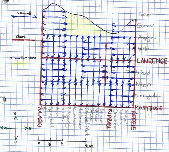
These businesses supply everyday items (grocery stores, pharmacies, Laundromat), occasional purchases (hairdresser, shoe store, movie theater), and specialized goods and services (lawyers, medical specialists, furniture). There are very few things a family could need that cannot be found on Lawrence Avenue, and whatever is not stocked on Lawrence can be found in one of the big-box stores on Pulaski Road. As is typical of the Chicago grid layout, another commercial street is half a mile south of Lawrence, on Montrose Avenue. Given the high frequency of north/south blocks and alleys providing foot access to the major streets, almost the entire neighborhood is within 5 minutes’ walk of a commercial strip. Many people live within 5 minutes of multiple commercial corridors, particularly those near Lawrence and Kimball.
Half a mile north of Lawrence, on Foster Avenue, however, there is no commercial street, because of the interruption of the Chicago River. People may choose to live there, though, because of the proximity to the river and its surrounding parks. No part of the neighborhood is more than 10 minutes away from a major commercial center, and snack vendor carts pop up on residential corners throughout the neighborhood, adding more convenience.
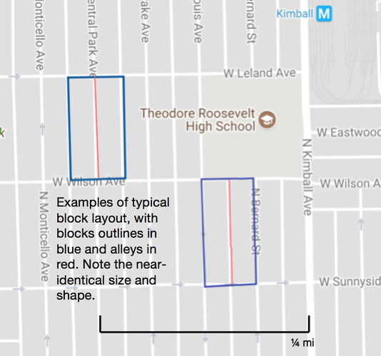
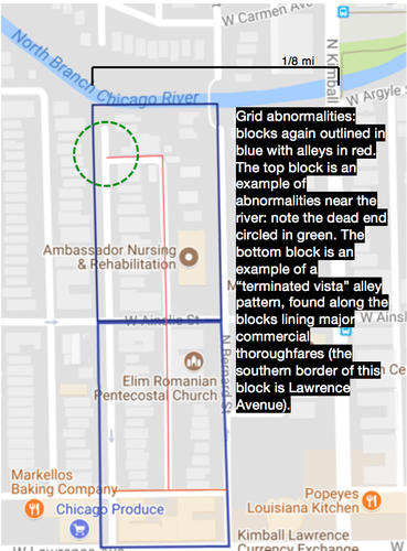
1. 1. Block types: Albany Park is almost entirely comprised of rectangular elongated blocks, all the same size, with alleys running north/south between them. The exception to this layout is near the river, where its interruption necessitates dead ends.
2. 2. Network types: Like almost all of Chicago, Albany Park features a regular Savannah-style orthogonal grid.
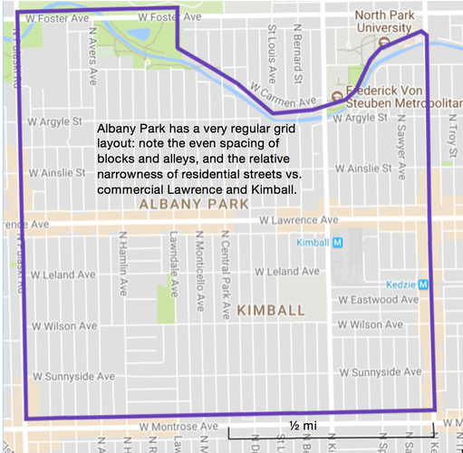
3. 3. Thoroughfare types: Although many of them feature “Avenue” in the name, the vast majority of thoroughfares in Albany Park more closely resemble residential streets. They are relatively narrow, often only allow one-way traffic, and are lined with trees. They allow for dense building, and residential streets feature both single-family homes and multi-family apartment buildings.
Albany Park has a very regular grid-based layout. The orthogonal layout and general regularity of alleys makes the neighborhood easily navigable, while occasional variation in alley layout, usually due to some unique feature of the block (some building that used to be on that site, or proximity either to shops or to the river), makes navigation somewhat more interesting. Block lengths are short in the east/west direction—350 feet per block with alleys spaced halfway—and a bit longer in the north/south direction—660 feet or 1/8 mi, in accordance with the Chicago grid system. Each block is approximately 5 acres. Almost every street is a through street, so no part of the neighborhood is isolated in a cul-de-sac fashion. The main commercial arterials, while wider than the residential streets, are still densely built and resemble commercial streets more closely than avenues. Car traffic is heavier on these streets, but not heavy or fast enough so as to deter pedestrian activity. These features combine to create a walkable, human-scaled neighborhood.
Albany Park has it all: beautiful architecture, a wide variety of shops and services, high-quality transit connections, and a diverse and close-knit community. The one thing it lacks is adequate space for its community to come together. Albany Parkers have overcome this lack of public space by gathering and socializing in commercial and residential spaces, but proper public space would make this community’s already strong bonds even stronger.
PROPOSAL A: PEDESTRIAN BENCHES ON LAWRENCE AVENUE
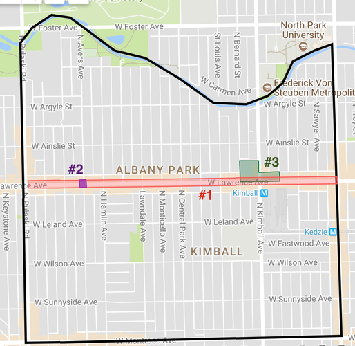
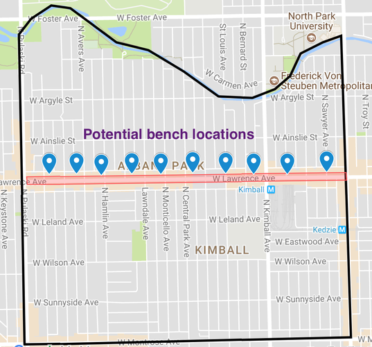
Lawrence Avenue is the commercial and cultural heart of the neighborhood. In addition to hosting the #81 bus and Brown Line terminal, Lawrence Avenue has the densest concentration of small businesses of Albany Park’s commercial streets. Many of these businesses are locally owned and either cater or pay homage to the owners’ cultural and ethnic identities. Lawrence is narrower than Pulaski Road or Kedzie Avenue, the other commercial thoroughfares of comparable significance, so car traffic is lighter. Most of its buildings are relatively old, so they are small, short, and varied, making for a scenic, non-overwhelming pedestrian experience. Because of the street’s local importance and its walkability, it has become a de facto social center. Since there are no public gathering spaces, residents stroll or loiter on Lawrence instead. I propose a series of seating improvements to capitalize on this impromptu social space. Adding benches to the sidewalk, near the curb so as not to impede the flow of foot traffic, will legitimize the street as a gathering space and assist shoppers and pedestrians with mobility issues. They will provide seating for patrons of sidewalk snack carts.
PROPOSAL B: ART AT LAWRENCE AND SPRINGFIELD
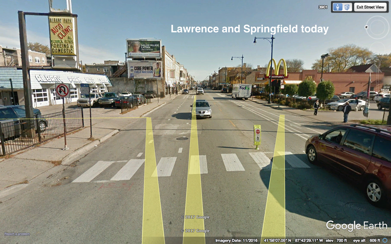
Albany Park plays host to a wide variety of cultures and languages; its diversity is a major component of its identity. The shops on Lawrence display this diversity, but west of Central Park Avenue, vacant storefronts become common. While the commercial strip continues over to Pulaski Road, a pedestrian walking west might be discouraged by the visual blight from continuing past this section. The corner of Lawrence and Springfield is arguably the least vibrant in this strip: it hosts a McDonalds, one of the only chain restaurants in Albany Park, and a dilapidated car wash, which takes up a large portion of the block. Since the buildings are set back father from the curb than usual, this corner provides a good canvas for development. I propose an art installation in this space that pays tribute to Albany Park’s signature diversity. Art is accessible to all Albany Parkers regardless of language, and the beautification effect will indicate that the street is intended for pedestrian traffic. It will encourage pedestrians to walk the quieter half of Lawrence Avenue, potentially providing a spark for reinvestment in vacant retail spaces.
PROPOSAL C: PEDESTRIAN PLAZA AT LAWRENCE AND KIMBALL
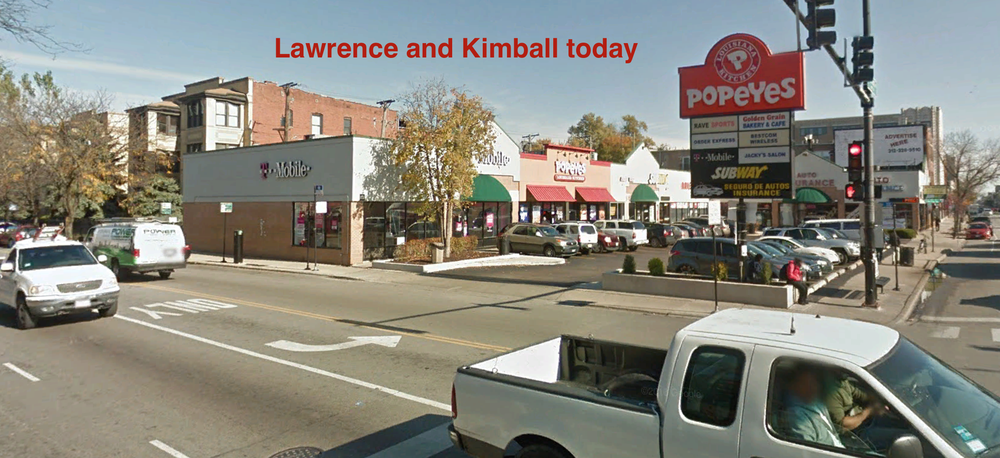
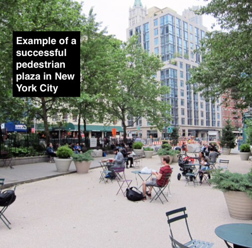
The one feature Albany Park lacks is a public space built intentionally for gathering. The only options residents currently have for socializing are local religious centers and commercial streets. The intersection of Lawrence and Kimball is the location for the Brown Line terminal and trainyard. It is the point of entry for visitors and the primary link to the city for residents; as a result, it is one of the most heavily trafficked corners in the neighborhood. It is, unfortunately, one of the ugliest spots on the avenue. Opposite the train station is small strip of chain restaurants, with a large drive-in bank branch opposite it. I propose reclaiming these two lots to construct a public plaza with seating and greenery. Closing the chains would not harm local businesses (and Lawrence Avenue has plenty of dining options), and the bank has another branch down the block. Creating a designated public space in an area residents already pass through frequently increases the chances that the space will see heavy use, and will provide a welcoming gateway to travelers exiting the Brown Line.
Image Sources:
Social Mix